Verenigde Staten Postcode: 52501
Dit is de paginalijst van Iowa Postcode 52501. Hieronder is het detail van Staat, Graafschap, Stad, Lengte, Breedtegraad, Envelop Voorbeeld, Bevolking.
Postcode 52501 Informatie

-
-
Land:
U.S. - Verenigde Staten
Staat:
Staat FIPS:
19
Netnummer:
Postcode:
52501
Postcode Type:
S (Standard)
❓Wat betekent S (Standard)? Een "standaard" postcode is waar de meeste mensen aan denken als ze het over postcodes hebben - in wezen een stad, een stad of een afdeling van een stad die een postdienst heeft.
Postcode 52501 - Stad

Dit is de stadsinformatie die overeenkomt met 52501:
| Staat | Graafschap | Stad | Stadtype ?In many cases, a ZIP Code can have multiple "names", meaning cities, towns, or subdivisions, in its boundaries. However, it will ALWAYS have exactly 1 "default" name. D - Default - This is the "preferred" name - by the USPS - for a city. Each ZIP Code has one - and only one - "default" name. In most cases, this is what people who live in that area call the city as well. A - Acceptable - This name can be used for mailing purposes. Often times alternative names are large neighborhoods or sections of the city/town. In some cases a ZIP Code may have several "acceptable" names which is used to group towns under one ZIP Code. N - Not Acceptable - A "not acceptable" name is, in many cases, a nickname that residents give that location. According to the USPS, you should NOT send mail to that ZIP Code using the "not acceptable" name when mailing. | Postcode |
|---|---|---|---|---|
| IA | Wapello | Bladensburg | N (Not Acceptable) | 52501 |
| IA | Wapello | Cliffland | N (Not Acceptable) | 52501 |
| IA | Wapello | Dahlonega | N (Not Acceptable) | 52501 |
| IA | Wapello | Dudley | N (Not Acceptable) | 52501 |
| IA | Wapello | Ottumwa | D (Default) | 52501 |
| IA | Wapello | Ottumwa Junction | N (Not Acceptable) | 52501 |
| IA | Wapello | Rutledge | N (Not Acceptable) | 52501 |
| IA | Wapello | South Ottumwa | N (Not Acceptable) | 52501 |
❓Wat betekent D (Default)? Dit is de "geprefereerde" naam - door de USPS - voor een stad. Elke postcode heeft één - en slechts één - "standaard" naam. In de meeste gevallen noemen mensen die in dat gebied wonen de stad ook.
❓Wat betekent N (Not Acceptable)? Een "niet acceptabele" naam is in veel gevallen een bijnaam die bewoners aan die locatie geven. Volgens de USPS mag je GEEN post naar die postcode sturen met de "niet acceptabele" naam bij het mailen.
Postcode 52501 Plus 4
ZIP Code 5 plus 4 is de uitbreiding van de 5-cijferige postcode, het kan worden gebruikt om een meer gedetailleerde locatie te vinden. De laatste vier cijfers duiden een segment of een kant van een straat of een appartement aan. Hieronder vindt u de postcode en het bijbehorende adres van de postcode 52501.
| Postcode 5 Plus 4 | Adres |
|---|---|
| 52501-0001 | PO BOX 1, OTTUMWA, IA |
| 52501-0016 | PO BOX 1801, OTTUMWA, IA |
| 52501-0020 | PO BOX 20, OTTUMWA, IA |
| 52501-0047 | PO BOX 1805, OTTUMWA, IA |
| 52501-0051 | PO BOX 51, OTTUMWA, IA |
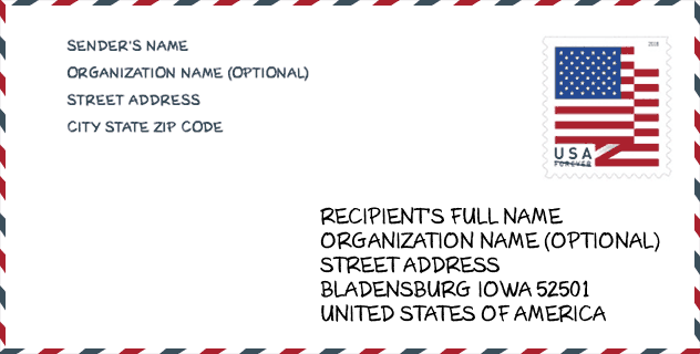
Envelop Voorbeeld

Dit is een voorbeeld van een Amerikaanse postenvelop. U kunt een 5-cijferige postcode of een gedetailleerde 9-cijferige postcode gebruiken om de mail in het volgende adresformaat te kopiëren.
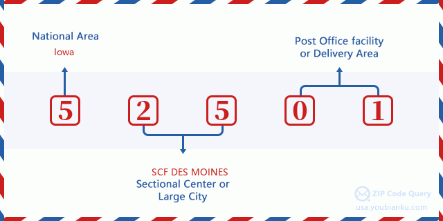
52501 Basisbetekenis
Waar staat elk cijfer van postcode 52501 voor? Het eerste cijfer geeft een nationaal gebied aan, dat varieert van nul voor het noordoosten tot negen voor het verre westen. De 2-3 cijfers zijn de code van een sectiecentrumfaciliteit in die regio. De laatste twee cijfers duiden kleine postkantoren of postzones aan.
Online landkaart

Het is een online kaart van adres South Ottumwa, Iowa, United States. U kunt Knopje gebruiken te in/uitzoomen. De kaartinformatie is alleen ter referentie.
Universiteit

This is the ZIP Code 52501 - University page list. Its detail university Name, Street, City, State, ZIP Code, Phone is as below.
| Naam | Straat | Stad | Staat | Postcode | Telefoon |
| Indian Hills Community College | 525 Grandview Ave | Ottumwa | IA | 52501 | (641) 683-5111 |
| Iowa School of Beauty-Ottumwa | 609 W Second St | Ottumwa | IA | 52501 | (641) 684-6504 |
Ziekenhuis

Het is de Postcode 52501 - Ziekenhuis pagina lijst. Het detail Ziekenhuisnaam, straat, stad, staat, postcode, telefoon is zoals hieronder.
- Naam: OTTUMWA REGIONAL HEALTH CENTER
- Adres: OTTUMWA
- Stad: 1001 E PENNSYLVANIA
- Staat: IA
- Postcode: 52501
- Telefoon: (641) 682-7511
Museum

Dit is de paginalijst van Postcode 52501 - Museum. Hieronder is het detail van Museum Naam, Straat, Stad, Staat, Postcode, Telefoon.
| Naam | Straat | Stad | Staat | Postcode | Telefoon |
| NAVAL AIR STATION OTTUMWA | 14550 TERMINAL AVE | OTTUMWA | IA | 52501 | |
| INDIAN HILLS ART GALLERY | 525 GRANDVIEW AVENUE | OTTUMWA | IA | 52501 | (641) 683-5111 |
Bibliotheek

Dit is de paginalijst van Postcode 52501 - Bibliotheek. Hieronder is het detail van Bibliotheek Naam, Adres, Stad, Staat, Postcode, Telefoon.
- Naam: OTTUMWA PUBLIC LIBRARY
- Adres: 102 W 4TH ST
- Stad: OTTUMWA
- Staat: IA - Iowa
- Postcode: 52501
- Telefoon: (641) 682-7563
School
Dit is de paginalijst van Postcode 52501 - School. Hieronder is het detail van School Naam, Adres, Stad, Staat, Postcode.
| School Naam | Adres | Stad | Staat | Klassen | Postcode |
|---|---|---|---|---|---|
| Eisenhower Elementary School | 2624 Marilyn Rd | Ottumwa | IA | UG | 52501 |
| Evans Middle School | 812 CHESTER AVENUE | Ottumwa | IA | UG | 52501 |
| Horace Mann Elementary School | 1523 N Court St | Ottumwa | IA | UG | 52501 |
| James Elementary School | 1001 N BENTON | Ottumwa | IA | UG | 52501 |
| Ottumwa High School | 501 E 2ND | Ottumwa | IA | UG | 52501 |
| Wilson Elementary School | 1102 E. 4TH ST. | Ottumwa | IA | UG | 52501 |
| Pickwick Early Childhood Center | 1306 W WILLIAMS | Ottumwa | IA | UG | 52501 |
| Liberty Elementary School | 50 TRAXLER DRIVE | Ottumwa | IA | UG | 52501 |
| Douma Elementary School | 307 W. MARY ST. | Ottumwa | IA | UG | 52501 |
| Ottumwa Virtual Learning | 1112 N Van Buren | Ottumwa | IA | UG | 52501 |
Population for Postcode 52501

What is the total population in ZIP Code 52501? Below is detail information.
- Population for Postcode 52501: 29,457
- 2010 Bevolking: 30,220
The 2020 demographic statistics are in progress. The current population in ZIP code 52501 is 29,457, and the population in 2010 is 30,220.
Geslacht

In all the statistical population, the male population is 14,765, the female population is 15,455.
- Male Population: 14,765
- Female Population: 15,455
Race

In all the statistical population, the male population is 14,765, the female population is 15,455.
- White Population: 27,963
- Black Population: 666
- Hispanic Population: 3,141
- Asian Population: 325
- Hawaiian Population: 72
- Indian Population: 310
- Other Population: 1,413
Leeftijd

In all the statistical population, the White population is 27,963, the Black population is 666, the Hispanic population is 3,141, the Asian population is 325, the Hawaiian population is 72, the Indian Ppopulation is 310 and Other population is 1,413.
- Age's Median: 39.1
- Median of male age: 37.1
- Median of female age: 41.1
Households for Postcode 52501
ZIP code 52501 has 12,317 households, with an average number of 2.38 persons per household. The average income per household in Zip code 52501 is 43,600 USD, and the average house value is 80,600 USD.
- Households Per Zipcode: 12,317
- Personen per huishouden: 2.38
- Gemiddelde huiswaarde: 80,600
- Inkomen per huishouden: 43,600
Geographic

The latitude of the Zip code 52501 is 41.030568, the longitude is -92.411704, and the elevation is 800. It has land area of 225.669 square miles, and water area of 2.668 square miles. The time zone for ZIP code 52501 is Central (GMT -06:00). Daylight saving time should be observed in the area where the zip code is located.
- Breedtegraad: 41.030568
- Lengte: -92.411704
- Elevatie: 800
- Landoppervlak: 225.669
- Water Area: 2.668
- Tijd Zone: Central (GMT -06:00)
- Regio: Midwest
- Divisie: West North Central
- Zomertijd: Y
congresdistrict

The Congressional District for ZIP code 52501 is Iowa's 2nd congressional district, the Congressional Land Area is 12261.92 square mile.
- congresdistrict: 2nd
- Congresgebied: 12261.92
Levering

In the ZIP code 52501, there are 12,377 residential delivery mailboxes and centralized units, and 917 commercial delivery mailbox and centralized units, 11,001 single family deliveries and 1,080 multifamily deliveries, and the box count is 13,795. The main post office has city delivery carrier routes for the ZIP code 52501.
- Delivery Residential: 12,377
- Delivery Business: 917
- Delivery Total: 13,795
- Leveringseenheden voor één gezin: 11,001
- Multi Family Delivery Units: 1,080
- Stadsleveringsindicator: Y
Bedrijf

In ZIP code 52501, the number of business is 642, the number of employee is 13,617, the business first quarter payroll is 117,652,000 USD, the business annual payroll is 525,105,000 USD.
- Number Of Businesses: 642
- Number Of Employees: 13,617
- Zakelijke salarisadministratie eerste kwartaal: 117,652,000
- Zakelijke jaarlijkse loonlijst: 525,105,000
Sociale zekerheid

Er zijn 6,875 begunstigden met uitkeringen in de huidige betalingsstatus voor postcode 52501, waarvan 4,520 gepensioneerde werknemers, 1,135 gehandicapte werknemers, 535 weduwnaar (eren) en ouders, 225 zijn echtgenoten en 460 zijn kinderen. Het aantal begunstigden van 65 jaar of ouder is 4,945. De totale maandelijkse uitkeringen bedragen 8,847,000 USD, waarvan 6,392,000 USD voor gepensioneerde werknemers, 713,000 USD voor weduwnaar (eren) en ouders.
- Totaal aantal: 6,875
- Aantal gepensioneerden: 4,520
- Aantal gehandicapte werknemers: 1,135
- Weduwe / weduwnaar (er) en ouders Aantal: 535
- Echtgenoten nummer: 225
- Aantal kinderen: 460
- Alle begunstigden per maand: 8,847,000
- Gepensioneerde werknemers per maand: 6,392,000
- Weduwe (n) en ouders per maand: 713,000
- Aantal begunstigden van 65 jaar of ouder: 4,945


Reactie toevoegen