Verenigde Staten Postcode: 58078
Dit is de paginalijst van North Dakota Postcode 58078. Hieronder is het detail van Staat, Graafschap, Stad, Lengte, Breedtegraad, Envelop Voorbeeld, Bevolking.

Postcode 58078 Informatie

-
-
Land:
U.S. - Verenigde Staten
Staat:
Staat FIPS:
38
Netnummer:
Postcode:
58078
Postcode Type:
S (Standard)
❓Wat betekent S (Standard)? Een "standaard" postcode is waar de meeste mensen aan denken als ze het over postcodes hebben - in wezen een stad, een stad of een afdeling van een stad die een postdienst heeft.
Postcode 58078 - Stad

Dit is de stadsinformatie die overeenkomt met 58078:
| Staat | Graafschap | Stad | Stadtype ?In many cases, a ZIP Code can have multiple "names", meaning cities, towns, or subdivisions, in its boundaries. However, it will ALWAYS have exactly 1 "default" name. D - Default - This is the "preferred" name - by the USPS - for a city. Each ZIP Code has one - and only one - "default" name. In most cases, this is what people who live in that area call the city as well. A - Acceptable - This name can be used for mailing purposes. Often times alternative names are large neighborhoods or sections of the city/town. In some cases a ZIP Code may have several "acceptable" names which is used to group towns under one ZIP Code. N - Not Acceptable - A "not acceptable" name is, in many cases, a nickname that residents give that location. According to the USPS, you should NOT send mail to that ZIP Code using the "not acceptable" name when mailing. | Postcode |
|---|---|---|---|---|
| ND | Cass | Riverside | A (Acceptable) | 58078 |
| ND | Cass | West Fargo | D (Default) | 58078 |
❓Wat betekent D (Default)? Dit is de "geprefereerde" naam - door de USPS - voor een stad. Elke postcode heeft één - en slechts één - "standaard" naam. In de meeste gevallen noemen mensen die in dat gebied wonen de stad ook.
❓Wat betekent A (Acceptable)? Deze naam kan worden gebruikt voor mailingdoeleinden. Vaak zijn alternatieve namen grote buurten of delen van de stad / stad. In sommige gevallen kan een postcode meerdere "acceptabele" namen hebben die worden gebruikt om steden onder één postcode te groeperen.
Postcode 58078 Plus 4
ZIP Code 5 plus 4 is de uitbreiding van de 5-cijferige postcode, het kan worden gebruikt om een meer gedetailleerde locatie te vinden. De laatste vier cijfers duiden een segment of een kant van een straat of een appartement aan. Hieronder vindt u de postcode en het bijbehorende adres van de postcode 58078.
| Postcode 5 Plus 4 | Adres |
|---|---|
| 58078-0001 | PO BOX 1, WEST FARGO, ND |
| 58078-0010 | 25001 VERINCHA AVE, WEST FARGO, ND |
| 58078-0011 | PO BOX 11, WEST FARGO, ND |
| 58078-0331 | PO BOX 331, WEST FARGO, ND |
| 58078-0611 | PO BOX 611, WEST FARGO, ND |
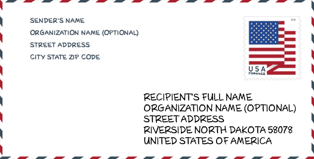
Envelop Voorbeeld

Dit is een voorbeeld van een Amerikaanse postenvelop. U kunt een 5-cijferige postcode of een gedetailleerde 9-cijferige postcode gebruiken om de mail in het volgende adresformaat te kopiëren.
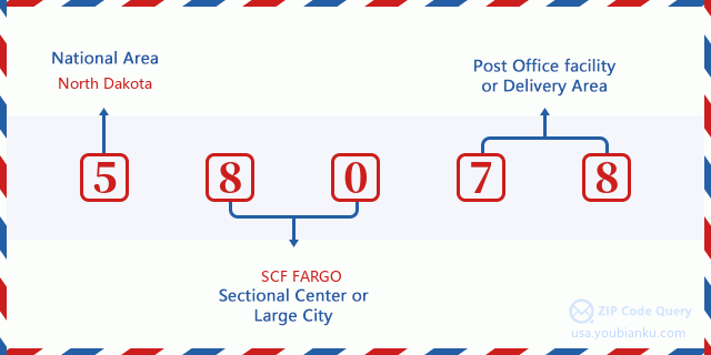
58078 Basisbetekenis
Waar staat elk cijfer van postcode 58078 voor? Het eerste cijfer geeft een nationaal gebied aan, dat varieert van nul voor het noordoosten tot negen voor het verre westen. De 2-3 cijfers zijn de code van een sectiecentrumfaciliteit in die regio. De laatste twee cijfers duiden kleine postkantoren of postzones aan.
Online landkaart

Het is een online kaart van adres West Fargo, North Dakota, United States. U kunt Knopje gebruiken te in/uitzoomen. De kaartinformatie is alleen ter referentie.
Museum

Dit is de paginalijst van Postcode 58078 - Museum. Hieronder is het detail van Museum Naam, Straat, Stad, Staat, Postcode, Telefoon.
| Naam | Straat | Stad | Staat | Postcode | Telefoon |
| DINOSAURS AND MORE | 705 MAIN AVE E | WEST FARGO | ND | 58078 | (701) 226-9622 |
| DISCOVER MUSEUM | 843 HOMESTEAD CT | WEST FARGO | ND | 58078 |
Bibliotheek

Dit is de paginalijst van Postcode 58078 - Bibliotheek. Hieronder is het detail van Bibliotheek Naam, Adres, Stad, Staat, Postcode, Telefoon.
| Naam | Adres | Stad | Staat | Postcode | Telefoon |
|---|---|---|---|---|---|
| WEST FARGO PUBLIC LIBRARY | 109 THIRD STREET EAST | WEST FARGO | ND | 58078 | (701) 551-8940 |
| WEST FARGO PUBLIC LIBRARY | 109 THIRD STREET EAST | WEST FARGO | ND | 58078 | (701) 433-5460 |
School

Dit is de paginalijst van Postcode 58078 - School. Hieronder is het detail van School Naam, Adres, Stad, Staat, Postcode.
| School Naam | Adres | Stad | Staat | Klassen | Postcode |
|---|---|---|---|---|---|
| EARLY CHILDHOOD CENTER | 330 3rd Ave E | West Fargo | ND | UG | 58078 |
| EASTWOOD ELEMENTARY SCHOOL | 500 10th Ave E | West Fargo | ND | UG | 58078 |
| CHENEY MIDDLE SCHOOL | 825 17th Ave E | West Fargo | ND | UG | 58078 |
| SOUTH ELEMENTARY SCHOOL | 117 6th Ave W | West Fargo | ND | UG | 58078 |
| WEST FARGO HIGH SCHOOL | 801 9th St E | West Fargo | ND | UG | 58078 |
| WESTSIDE ELEMENTARY SCHOOL | 945 7th Ave W | West Fargo | ND | UG | 58078 |
| L E BERGER ELEMENTARY SCHOOL | 631 4th Ave E | West Fargo | ND | UG | 58078 |
| AURORA ELEMENTARY SCHOOL | 3420 9th St W | West Fargo | ND | UG | 58078 |
| WEST FARGO SHEYENNE HIGH SCHOOL | 800 40th Ave E | West Fargo | ND | UG | 58078 |
| FREEDOM ELEMENTARY SCHOOL | 401 26th Ave E | West Fargo | ND | UG | 58078 |
| LIBERTY MIDDLE SCHOOL | 801 36th Ave E | West Fargo | ND | UG | 58078 |
| LEGACY ELEMENTARY SCHOOL | 5150 9th St W | West Fargo | ND | UG | 58078 |
| BROOKS HARBOR ELEMENTARY SCHOOL | 801 22nd Ave W | West Fargo | ND | UG | 58078 |
| WEST FARGO HIGH VIRTUAL ACADEMY | 207 Main Ave W | West Fargo | ND | UG | 58078 |
| WEST FARGO ELEMENTARY VIRTUAL ACADEMY | 207 Main Ave W | West Fargo | ND | UG | 58078 |
| WEST FARGO MIDDLE VIRTUAL ACADEMY | 207 Main Ave W | West Fargo | ND | UG | 58078 |
| WEST FARGO COMMUNITY HIGH SCHOOL | 311 1st Avenue E | West Fargo | ND | UG | 58078 |
Population for Postcode 58078

What is the total population in ZIP Code 58078? Below is detail information.
- Population for Postcode 58078: 40,392
- 2010 Bevolking: 26,321
The 2020 demographic statistics are in progress. The current population in ZIP code 58078 is 40,392, and the population in 2010 is 26,321.
Geslacht

In all the statistical population, the male population is 13,075, the female population is 13,246.
- Male Population: 13,075
- Female Population: 13,246
Race

In all the statistical population, the male population is 13,075, the female population is 13,246.
- White Population: 25,053
- Black Population: 651
- Hispanic Population: 474
- Asian Population: 484
- Hawaiian Population: 13
- Indian Population: 447
- Other Population: 153
Leeftijd

In all the statistical population, the White population is 25,053, the Black population is 651, the Hispanic population is 474, the Asian population is 484, the Hawaiian population is 13, the Indian Ppopulation is 447 and Other population is 153.
- Age's Median: 32.7
- Median of male age: 32.6
- Median of female age: 32.9
Households for Postcode 58078
ZIP code 58078 has 10,527 households, with an average number of 2.50 persons per household. The average income per household in Zip code 58078 is 81,616 USD, and the average house value is 228,700 USD.
- Households Per Zipcode: 10,527
- Personen per huishouden: 2.50
- Gemiddelde huiswaarde: 228,700
- Inkomen per huishouden: 81,616
Geographic

The latitude of the Zip code 58078 is 46.869862, the longitude is -96.936294, and the elevation is 897. It has land area of 39.262 square miles, and water area of 0.353 square miles. The time zone for ZIP code 58078 is Central (GMT -06:00). Daylight saving time should be observed in the area where the zip code is located.
- Breedtegraad: 46.869862
- Lengte: -96.936294
- Elevatie: 897
- Landoppervlak: 39.262
- Water Area: 0.353
- Tijd Zone: Central (GMT -06:00)
- Regio: Midwest
- Divisie: West North Central
- Zomertijd: Y
Levering

In the ZIP code 58078, there are 16,157 residential delivery mailboxes and centralized units, and 904 commercial delivery mailbox and centralized units, 5,737 single family deliveries and 3,496 multifamily deliveries, and the box count is 17,251. The main post office has city delivery carrier routes for the ZIP code 58078.
- Delivery Residential: 16,157
- Delivery Business: 904
- Delivery Total: 17,251
- Leveringseenheden voor één gezin: 5,737
- Multi Family Delivery Units: 3,496
- Stadsleveringsindicator: Y
Bedrijf

In ZIP code 58078, the number of business is 842, the number of employee is 12,152, the business first quarter payroll is 135,931,000 USD, the business annual payroll is 568,794,000 USD.
- Number Of Businesses: 842
- Number Of Employees: 12,152
- Zakelijke salarisadministratie eerste kwartaal: 135,931,000
- Zakelijke jaarlijkse loonlijst: 568,794,000
Sociale zekerheid

Er zijn 4,690 begunstigden met uitkeringen in de huidige betalingsstatus voor postcode 58078, waarvan 3,465 gepensioneerde werknemers, 485 gehandicapte werknemers, 300 weduwnaar (eren) en ouders, 135 zijn echtgenoten en 305 zijn kinderen. Het aantal begunstigden van 65 jaar of ouder is 3,655. De totale maandelijkse uitkeringen bedragen 6,776,000 USD, waarvan 5,379,000 USD voor gepensioneerde werknemers, 444,000 USD voor weduwnaar (eren) en ouders.
- Totaal aantal: 4,690
- Aantal gepensioneerden: 3,465
- Aantal gehandicapte werknemers: 485
- Weduwe / weduwnaar (er) en ouders Aantal: 300
- Echtgenoten nummer: 135
- Aantal kinderen: 305
- Alle begunstigden per maand: 6,776,000
- Gepensioneerde werknemers per maand: 5,379,000
- Weduwe (n) en ouders per maand: 444,000
- Aantal begunstigden van 65 jaar of ouder: 3,655


Reactie toevoegen