Verenigde Staten Postcode: 58852
Dit is de paginalijst van North Dakota Postcode 58852. Hieronder is het detail van Staat, Graafschap, Stad, Lengte, Breedtegraad, Envelop Voorbeeld, Bevolking.

Postcode 58852 Informatie

-
-
Land:
U.S. - Verenigde Staten
Staat:
Staat FIPS:
38
Netnummer:
Postcode:
58852
Postcode Type:
S (Standard)
❓Wat betekent S (Standard)? Een "standaard" postcode is waar de meeste mensen aan denken als ze het over postcodes hebben - in wezen een stad, een stad of een afdeling van een stad die een postdienst heeft.
Postcode 58852 - Stad

Dit is de stadsinformatie die overeenkomt met 58852:
| Staat | Graafschap | Stad | Stadtype ?In many cases, a ZIP Code can have multiple "names", meaning cities, towns, or subdivisions, in its boundaries. However, it will ALWAYS have exactly 1 "default" name. D - Default - This is the "preferred" name - by the USPS - for a city. Each ZIP Code has one - and only one - "default" name. In most cases, this is what people who live in that area call the city as well. A - Acceptable - This name can be used for mailing purposes. Often times alternative names are large neighborhoods or sections of the city/town. In some cases a ZIP Code may have several "acceptable" names which is used to group towns under one ZIP Code. N - Not Acceptable - A "not acceptable" name is, in many cases, a nickname that residents give that location. According to the USPS, you should NOT send mail to that ZIP Code using the "not acceptable" name when mailing. | Postcode |
|---|---|---|---|---|
| ND | Williams | Temple | A (Acceptable) | 58852 |
| ND | Williams | Tioga | D (Default) | 58852 |
❓Wat betekent D (Default)? Dit is de "geprefereerde" naam - door de USPS - voor een stad. Elke postcode heeft één - en slechts één - "standaard" naam. In de meeste gevallen noemen mensen die in dat gebied wonen de stad ook.
❓Wat betekent A (Acceptable)? Deze naam kan worden gebruikt voor mailingdoeleinden. Vaak zijn alternatieve namen grote buurten of delen van de stad / stad. In sommige gevallen kan een postcode meerdere "acceptabele" namen hebben die worden gebruikt om steden onder één postcode te groeperen.
Postcode 58852 Plus 4
ZIP Code 5 plus 4 is de uitbreiding van de 5-cijferige postcode, het kan worden gebruikt om een meer gedetailleerde locatie te vinden. De laatste vier cijfers duiden een segment of een kant van een straat of een appartement aan. Hieronder vindt u de postcode en het bijbehorende adres van de postcode 58852.
| Postcode 5 Plus 4 | Adres |
|---|---|
| 58852-0001 | PO BOX 1, TIOGA, ND |
| 58852-0010 | 16600 YORIDALE ST, TIOGA, ND |
| 58852-0011 | PO BOX 11, TIOGA, ND |
| 58852-0121 | PO BOX 121, TIOGA, ND |
| 58852-0241 | PO BOX 241, TIOGA, ND |
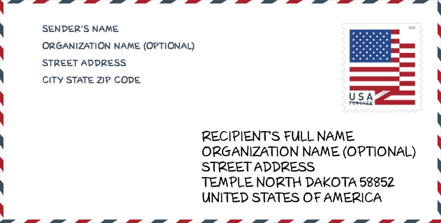
Envelop Voorbeeld

Dit is een voorbeeld van een Amerikaanse postenvelop. U kunt een 5-cijferige postcode of een gedetailleerde 9-cijferige postcode gebruiken om de mail in het volgende adresformaat te kopiëren.
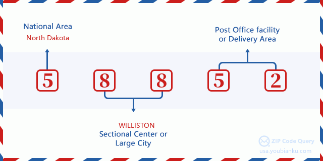
58852 Basisbetekenis
Waar staat elk cijfer van postcode 58852 voor? Het eerste cijfer geeft een nationaal gebied aan, dat varieert van nul voor het noordoosten tot negen voor het verre westen. De 2-3 cijfers zijn de code van een sectiecentrumfaciliteit in die regio. De laatste twee cijfers duiden kleine postkantoren of postzones aan.
Online landkaart

Het is een online kaart van adres Tioga, North Dakota, United States. U kunt Knopje gebruiken te in/uitzoomen. De kaartinformatie is alleen ter referentie.
Ziekenhuis

Het is de Postcode 58852 - Ziekenhuis pagina lijst. Het detail Ziekenhuisnaam, straat, stad, staat, postcode, telefoon is zoals hieronder.
- Naam: TIOGA MEDICAL CENTER
- Adres: TIOGA
- Stad: 810 N WELO ST
- Staat: ND
- Postcode: 58852
- Telefoon: (701) 664-3305
Museum

Dit is de paginalijst van Postcode 58852 - Museum. Hieronder is het detail van Museum Naam, Straat, Stad, Staat, Postcode, Telefoon.
| Naam | Straat | Stad | Staat | Postcode | Telefoon |
| NORSEMAN MUSEUM | 17 E 2ND ST | TIOGA | ND | 58852 | (701) 664-2702 |
| TIOGA HISTORICAL SOCIETY | PO BOX 699 | TIOGA | ND | 58852 |
School

Dit is de paginalijst van Postcode 58852 - School. Hieronder is het detail van School Naam, Adres, Stad, Staat, Postcode.
| School Naam | Adres | Stad | Staat | Klassen | Postcode |
|---|---|---|---|---|---|
| CENTRAL ELEMENTARY SCHOOL | 321 N Benson St | Tioga | ND | UG | 58852 |
| TIOGA HIGH SCHOOL | 303 N Linda St | Tioga | ND | UG | 58852 |
Population for Postcode 58852

What is the total population in ZIP Code 58852? Below is detail information.
- Population for Postcode 58852: 1,136
- 2010 Bevolking: 1,750
The 2020 demographic statistics are in progress. The current population in ZIP code 58852 is 1,136, and the population in 2010 is 1,750.
Geslacht

In all the statistical population, the male population is 910, the female population is 840.
- Male Population: 910
- Female Population: 840
Race

In all the statistical population, the male population is 910, the female population is 840.
- White Population: 1,726
- Black Population: 10
- Hispanic Population: 13
- Asian Population: 12
- Hawaiian Population: 3
- Indian Population: 26
- Other Population: 3
Leeftijd

In all the statistical population, the White population is 1,726, the Black population is 10, the Hispanic population is 13, the Asian population is 12, the Hawaiian population is 3, the Indian Ppopulation is 26 and Other population is 3.
- Age's Median: 48.2
- Median of male age: 45.8
- Median of female age: 50.5
Households for Postcode 58852
ZIP code 58852 has 770 households, with an average number of 2.19 persons per household. The average income per household in Zip code 58852 is 83,625 USD, and the average house value is 209,600 USD.
- Households Per Zipcode: 770
- Personen per huishouden: 2.19
- Gemiddelde huiswaarde: 209,600
- Inkomen per huishouden: 83,625
Housing Unit

In ZIP code 58852, the growth rank of housing unit is 3, the number of housing unit was 22,398 in 2010 and increased to 24,374 in 2011, the growth increase number is 1,976, the growth increase percentage is 8.8%.
- Growth Rank: 3
- Housing Units Estimate in 2010: 22,398
- Housing Units Estimate in 2011: 24,374
- Growth Increase Number: 1,976
- Growth Increase Percentage: 8.8%
Geographic

The latitude of the Zip code 58852 is 48.334011, the longitude is -102.928947, and the elevation is 2391. It has land area of 347.056 square miles, and water area of 20.265 square miles. The time zone for ZIP code 58852 is Central (GMT -06:00). Daylight saving time should be observed in the area where the zip code is located.
- Breedtegraad: 48.334011
- Lengte: -102.928947
- Elevatie: 2391
- Landoppervlak: 347.056
- Water Area: 20.265
- Tijd Zone: Central (GMT -06:00)
- Regio: Midwest
- Divisie: West North Central
- Zomertijd: Y
Levering

In the ZIP code 58852, there are 519 residential delivery mailboxes and centralized units, and 27 commercial delivery mailbox and centralized units, 243 single family deliveries and 130 multifamily deliveries, and the box count is 1,502. The main post office does not have city delivery carrier routes for the ZIP code 58852.
- Delivery Residential: 519
- Delivery Business: 27
- Delivery Total: 1,502
- Leveringseenheden voor één gezin: 243
- Multi Family Delivery Units: 130
- Stadsleveringsindicator: N
Bedrijf

In ZIP code 58852, the number of business is 125, the number of employee is 1,576, the business first quarter payroll is 39,798,000 USD, the business annual payroll is 130,384,000 USD.
- Number Of Businesses: 125
- Number Of Employees: 1,576
- Zakelijke salarisadministratie eerste kwartaal: 39,798,000
- Zakelijke jaarlijkse loonlijst: 130,384,000
Sociale zekerheid

Er zijn 370 begunstigden met uitkeringen in de huidige betalingsstatus voor postcode 58852, waarvan 285 gepensioneerde werknemers, 20 gehandicapte werknemers, 35 weduwnaar (eren) en ouders, 15 zijn echtgenoten en 15 zijn kinderen. Het aantal begunstigden van 65 jaar of ouder is 310. De totale maandelijkse uitkeringen bedragen 536,000 USD, waarvan 438,000 USD voor gepensioneerde werknemers, 49,000 USD voor weduwnaar (eren) en ouders.
- Totaal aantal: 370
- Aantal gepensioneerden: 285
- Aantal gehandicapte werknemers: 20
- Weduwe / weduwnaar (er) en ouders Aantal: 35
- Echtgenoten nummer: 15
- Aantal kinderen: 15
- Alle begunstigden per maand: 536,000
- Gepensioneerde werknemers per maand: 438,000
- Weduwe (n) en ouders per maand: 49,000
- Aantal begunstigden van 65 jaar of ouder: 310


Reactie toevoegen