Verenigde Staten Postcode: 66202
Dit is de paginalijst van Kansas Postcode 66202. Hieronder is het detail van Staat, Graafschap, Stad, Lengte, Breedtegraad, Envelop Voorbeeld, Bevolking.

Postcode 66202 Informatie

-
-
Land:
U.S. - Verenigde Staten
Staat:
Staat FIPS:
20
Netnummer:
Postcode:
66202
Postcode Type:
S (Standard)
❓Wat betekent S (Standard)? Een "standaard" postcode is waar de meeste mensen aan denken als ze het over postcodes hebben - in wezen een stad, een stad of een afdeling van een stad die een postdienst heeft.
Postcode 66202 - Stad

Dit is de stadsinformatie die overeenkomt met 66202:
| Staat | Graafschap | Stad | Stadtype ?In many cases, a ZIP Code can have multiple "names", meaning cities, towns, or subdivisions, in its boundaries. However, it will ALWAYS have exactly 1 "default" name. D - Default - This is the "preferred" name - by the USPS - for a city. Each ZIP Code has one - and only one - "default" name. In most cases, this is what people who live in that area call the city as well. A - Acceptable - This name can be used for mailing purposes. Often times alternative names are large neighborhoods or sections of the city/town. In some cases a ZIP Code may have several "acceptable" names which is used to group towns under one ZIP Code. N - Not Acceptable - A "not acceptable" name is, in many cases, a nickname that residents give that location. According to the USPS, you should NOT send mail to that ZIP Code using the "not acceptable" name when mailing. | Postcode |
|---|---|---|---|---|
| KS | Johnson | Countryside | A (Acceptable) | 66202 |
| KS | Johnson | Merriam | A (Acceptable) | 66202 |
| KS | Johnson | Mission | D (Default) | 66202 |
| KS | Johnson | Overland | N (Not Acceptable) | 66202 |
| KS | Johnson | Overland Park | A (Acceptable) | 66202 |
| KS | Johnson | Prairie Vlg | A (Acceptable) | 66202 |
| KS | Johnson | Roeland Park | A (Acceptable) | 66202 |
| KS | Johnson | Shawnee Mission | A (Acceptable) | 66202 |
| KS | Johnson | Shawnee Msn | A (Acceptable) | 66202 |
| KS | Johnson | Sm | N (Not Acceptable) | 66202 |
❓Wat betekent D (Default)? Dit is de "geprefereerde" naam - door de USPS - voor een stad. Elke postcode heeft één - en slechts één - "standaard" naam. In de meeste gevallen noemen mensen die in dat gebied wonen de stad ook.
❓Wat betekent A (Acceptable)? Deze naam kan worden gebruikt voor mailingdoeleinden. Vaak zijn alternatieve namen grote buurten of delen van de stad / stad. In sommige gevallen kan een postcode meerdere "acceptabele" namen hebben die worden gebruikt om steden onder één postcode te groeperen.
❓Wat betekent N (Not Acceptable)? Een "niet acceptabele" naam is in veel gevallen een bijnaam die bewoners aan die locatie geven. Volgens de USPS mag je GEEN post naar die postcode sturen met de "niet acceptabele" naam bij het mailen.
Postcode 66202 Plus 4
ZIP Code 5 plus 4 is de uitbreiding van de 5-cijferige postcode, het kan worden gebruikt om een meer gedetailleerde locatie te vinden. De laatste vier cijfers duiden een segment of een kant van een straat of een appartement aan. Hieronder vindt u de postcode en het bijbehorende adres van de postcode 66202.
| Postcode 5 Plus 4 | Adres |
|---|---|
| 66202-1000 | 5400 MACKEY ST, MISSION, KS |
| 66202-1001 | 5229 HADLEY ST, MISSION, KS |
| 66202-1002 | 5223 HADLEY ST, MISSION, KS |
| 66202-1003 | 5120 HADLEY CT #00000001 , MISSION, KS |
| 66202-1004 | 8401 W 52ND TER, MISSION, KS |
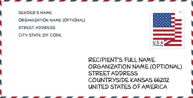
Envelop Voorbeeld

Dit is een voorbeeld van een Amerikaanse postenvelop. U kunt een 5-cijferige postcode of een gedetailleerde 9-cijferige postcode gebruiken om de mail in het volgende adresformaat te kopiëren.
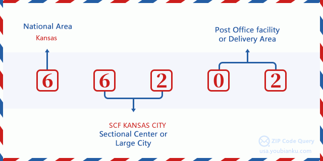
66202 Basisbetekenis
Waar staat elk cijfer van postcode 66202 voor? Het eerste cijfer geeft een nationaal gebied aan, dat varieert van nul voor het noordoosten tot negen voor het verre westen. De 2-3 cijfers zijn de code van een sectiecentrumfaciliteit in die regio. De laatste twee cijfers duiden kleine postkantoren of postzones aan.
Online landkaart

Het is een online kaart van adres Sm, Kansas, United States. U kunt Knopje gebruiken te in/uitzoomen. De kaartinformatie is alleen ter referentie.
Bibliotheek

Dit is de paginalijst van Postcode 66202 - Bibliotheek. Hieronder is het detail van Bibliotheek Naam, Adres, Stad, Staat, Postcode, Telefoon.
- Naam: ANTIOCH LIBRARY
- Adres: 8700 SHAWNEE MISSION PARKWAY
- Stad: MERRIAM
- Staat: KS - Kansas
- Postcode: 66202
- Telefoon: (913) 826-4600
School

Dit is de paginalijst van Postcode 66202 - School. Hieronder is het detail van School Naam, Adres, Stad, Staat, Postcode.
- School Naam: Project Finish
- Adres: 5900 Lamar
- Stad: Shawnee Mission
- Staat: KS
- Klassen: UG
- Postcode: 66202
Population for Postcode 66202

What is the total population in ZIP Code 66202? Below is detail information.
- Population for Postcode 66202: 18,000
- 2010 Bevolking: 16,173
The 2020 demographic statistics are in progress. The current population in ZIP code 66202 is 18,000, and the population in 2010 is 16,173.
Geslacht

In all the statistical population, the male population is 7,803, the female population is 8,370.
- Male Population: 7,803
- Female Population: 8,370
Race

In all the statistical population, the male population is 7,803, the female population is 8,370.
- White Population: 14,001
- Black Population: 1,141
- Hispanic Population: 1,635
- Asian Population: 667
- Hawaiian Population: 19
- Indian Population: 194
- Other Population: 700
Leeftijd

In all the statistical population, the White population is 14,001, the Black population is 1,141, the Hispanic population is 1,635, the Asian population is 667, the Hawaiian population is 19, the Indian Ppopulation is 194 and Other population is 700.
- Age's Median: 35.1
- Median of male age: 34.4
- Median of female age: 35.8
Households for Postcode 66202
ZIP code 66202 has 8,057 households, with an average number of 2.00 persons per household. The average income per household in Zip code 66202 is 58,510 USD, and the average house value is 163,700 USD.
- Households Per Zipcode: 8,057
- Personen per huishouden: 2.00
- Gemiddelde huiswaarde: 163,700
- Inkomen per huishouden: 58,510
Geographic

The latitude of the Zip code 66202 is 39.024654, the longitude is -94.669995, and the elevation is 1041. It has land area of 5.252 square miles, and water area of 0.013 square miles. The time zone for ZIP code 66202 is Central (GMT -06:00). Daylight saving time should be observed in the area where the zip code is located.
- Breedtegraad: 39.024654
- Lengte: -94.669995
- Elevatie: 1041
- Landoppervlak: 5.252
- Water Area: 0.013
- Tijd Zone: Central (GMT -06:00)
- Regio: Midwest
- Divisie: West North Central
- Zomertijd: Y
congresdistrict

The Congressional District for ZIP code 66202 is Kansas's 3rd congressional district, the Congressional Land Area is 757.2 square mile.
- congresdistrict: 3rd
- Congresgebied: 757.2
Levering

In the ZIP code 66202, there are 9,000 residential delivery mailboxes and centralized units, and 832 commercial delivery mailbox and centralized units, 5,105 single family deliveries and 2,792 multifamily deliveries, and the box count is 9,729. The main post office has city delivery carrier routes for the ZIP code 66202.
- Delivery Residential: 9,000
- Delivery Business: 832
- Delivery Total: 9,729
- Leveringseenheden voor één gezin: 5,105
- Multi Family Delivery Units: 2,792
- Stadsleveringsindicator: Y
Bedrijf

In ZIP code 66202, the number of business is 617, the number of employee is 13,089, the business first quarter payroll is 240,067,000 USD, the business annual payroll is 845,056,000 USD.
- Number Of Businesses: 617
- Number Of Employees: 13,089
- Zakelijke salarisadministratie eerste kwartaal: 240,067,000
- Zakelijke jaarlijkse loonlijst: 845,056,000
Sociale zekerheid

Er zijn 2,780 begunstigden met uitkeringen in de huidige betalingsstatus voor postcode 66202, waarvan 2,170 gepensioneerde werknemers, 270 gehandicapte werknemers, 155 weduwnaar (eren) en ouders, 85 zijn echtgenoten en 100 zijn kinderen. Het aantal begunstigden van 65 jaar of ouder is 2,315. De totale maandelijkse uitkeringen bedragen 4,402,000 USD, waarvan 3,619,000 USD voor gepensioneerde werknemers, 253,000 USD voor weduwnaar (eren) en ouders.
- Totaal aantal: 2,780
- Aantal gepensioneerden: 2,170
- Aantal gehandicapte werknemers: 270
- Weduwe / weduwnaar (er) en ouders Aantal: 155
- Echtgenoten nummer: 85
- Aantal kinderen: 100
- Alle begunstigden per maand: 4,402,000
- Gepensioneerde werknemers per maand: 3,619,000
- Weduwe (n) en ouders per maand: 253,000
- Aantal begunstigden van 65 jaar of ouder: 2,315


Reactie toevoegen