Verenigde Staten Postcode: 67601
Dit is de paginalijst van Kansas Postcode 67601. Hieronder is het detail van Staat, Graafschap, Stad, Lengte, Breedtegraad, Envelop Voorbeeld, Bevolking.

Postcode 67601 Informatie

-
-
Land:
U.S. - Verenigde Staten
Staat:
Staat FIPS:
20
Netnummer:
Postcode:
67601
Postcode Type:
S (Standard)
❓Wat betekent S (Standard)? Een "standaard" postcode is waar de meeste mensen aan denken als ze het over postcodes hebben - in wezen een stad, een stad of een afdeling van een stad die een postdienst heeft.
Postcode 67601 - Stad

Dit is de stadsinformatie die overeenkomt met 67601:
| Staat | Graafschap | Stad | Stadtype ?In many cases, a ZIP Code can have multiple "names", meaning cities, towns, or subdivisions, in its boundaries. However, it will ALWAYS have exactly 1 "default" name. D - Default - This is the "preferred" name - by the USPS - for a city. Each ZIP Code has one - and only one - "default" name. In most cases, this is what people who live in that area call the city as well. A - Acceptable - This name can be used for mailing purposes. Often times alternative names are large neighborhoods or sections of the city/town. In some cases a ZIP Code may have several "acceptable" names which is used to group towns under one ZIP Code. N - Not Acceptable - A "not acceptable" name is, in many cases, a nickname that residents give that location. According to the USPS, you should NOT send mail to that ZIP Code using the "not acceptable" name when mailing. | Postcode |
|---|---|---|---|---|
| KS | Ellis | Antonino | A (Acceptable) | 67601 |
| KS | Ellis | Hays | D (Default) | 67601 |
❓Wat betekent D (Default)? Dit is de "geprefereerde" naam - door de USPS - voor een stad. Elke postcode heeft één - en slechts één - "standaard" naam. In de meeste gevallen noemen mensen die in dat gebied wonen de stad ook.
❓Wat betekent A (Acceptable)? Deze naam kan worden gebruikt voor mailingdoeleinden. Vaak zijn alternatieve namen grote buurten of delen van de stad / stad. In sommige gevallen kan een postcode meerdere "acceptabele" namen hebben die worden gebruikt om steden onder één postcode te groeperen.
Postcode 67601 Plus 4
ZIP Code 5 plus 4 is de uitbreiding van de 5-cijferige postcode, het kan worden gebruikt om een meer gedetailleerde locatie te vinden. De laatste vier cijfers duiden een segment of een kant van een straat of een appartement aan. Hieronder vindt u de postcode en het bijbehorende adres van de postcode 67601.
| Postcode 5 Plus 4 | Adres |
|---|---|
| 67601-0001 | PO BOX 1, HAYS, KS |
| 67601-0091 | PO BOX 91, HAYS, KS |
| 67601-0181 | PO BOX 181, HAYS, KS |
| 67601-0271 | PO BOX 271, HAYS, KS |
| 67601-0361 | PO BOX 361, HAYS, KS |
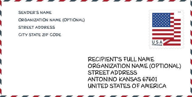
Envelop Voorbeeld

Dit is een voorbeeld van een Amerikaanse postenvelop. U kunt een 5-cijferige postcode of een gedetailleerde 9-cijferige postcode gebruiken om de mail in het volgende adresformaat te kopiëren.
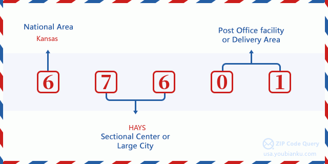
67601 Basisbetekenis
Waar staat elk cijfer van postcode 67601 voor? Het eerste cijfer geeft een nationaal gebied aan, dat varieert van nul voor het noordoosten tot negen voor het verre westen. De 2-3 cijfers zijn de code van een sectiecentrumfaciliteit in die regio. De laatste twee cijfers duiden kleine postkantoren of postzones aan.
Online landkaart

Het is een online kaart van adres Hays, Kansas, United States. U kunt Knopje gebruiken te in/uitzoomen. De kaartinformatie is alleen ter referentie.
Universiteit

This is the ZIP Code 67601 - University page list. Its detail university Name, Street, City, State, ZIP Code, Phone is as below.
| Naam | Straat | Stad | Staat | Postcode | Telefoon |
| Hays Academy of Hair Design | 1214 East 27th Street | Hays | KS | 67601 | (785) 628-6624 |
Ziekenhuis

Het is de Postcode 67601 - Ziekenhuis pagina lijst. Het detail Ziekenhuisnaam, straat, stad, staat, postcode, telefoon is zoals hieronder.
- Naam: HAYS MEDICAL CENTER
- Adres: HAYS
- Stad: 2220 CANTERBURY DRIVE
- Staat: KS
- Postcode: 67601
- Telefoon: (785) 623-5000
Museum

Dit is de paginalijst van Postcode 67601 - Museum. Hieronder is het detail van Museum Naam, Straat, Stad, Staat, Postcode, Telefoon.
| Naam | Straat | Stad | Staat | Postcode | Telefoon |
| FORT HAYS STATE HISTORIC SITE | 1472 US HIGHWAY 183 ALT | HAYS | KS | 67601 | (785) 625-6812 |
| STERNBERG MUSEUM OF NATURAL HISTORY | 3000 STERNBERG DRIVE | HAYS | KS | 67601 | (785) 628-4286 |
| MOSS-THORNS GALLERY | 600 PARK STREET | HAYS | KS | 67601 | (785) 628-4247 |
Bibliotheek

Dit is de paginalijst van Postcode 67601 - Bibliotheek. Hieronder is het detail van Bibliotheek Naam, Adres, Stad, Staat, Postcode, Telefoon.
- Naam: HAYS PUBLIC LIBRARY
- Adres: 1205 MAIN ST.
- Stad: HAYS
- Staat: KS - Kansas
- Postcode: 67601
- Telefoon: (785) 625-9014
School
Dit is de paginalijst van Postcode 67601 - School. Hieronder is het detail van School Naam, Adres, Stad, Staat, Postcode.
| School Naam | Adres | Stad | Staat | Klassen | Postcode |
|---|---|---|---|---|---|
| Lincoln Elem | 1906 Ash | Hays | KS | UG | 67601 |
| Woodrow Wilson Elem | 101 E 28th | Hays | KS | UG | 67601 |
| Hays Middle School | 201 W. 29th | Hays | KS | UG | 67601 |
| Roosevelt Elem | 2000 MacArthur | Hays | KS | UG | 67601 |
| Kathryn O'Loughlin McCarthy Elem | 1401 Hall | Hays | KS | UG | 67601 |
| Learning Center | 201 E 7th St | Hays | KS | UG | 67601 |
Population for Postcode 67601

What is the total population in ZIP Code 67601? Below is detail information.
- Population for Postcode 67601: 24,166
- 2010 Bevolking: 23,797
The 2020 demographic statistics are in progress. The current population in ZIP code 67601 is 24,166, and the population in 2010 is 23,797.
Geslacht

In all the statistical population, the male population is 11,831, the female population is 11,966.
- Male Population: 11,831
- Female Population: 11,966
Race

In all the statistical population, the male population is 11,831, the female population is 11,966.
- White Population: 22,510
- Black Population: 391
- Hispanic Population: 1,208
- Asian Population: 445
- Hawaiian Population: 17
- Indian Population: 201
- Other Population: 668
Leeftijd

In all the statistical population, the White population is 22,510, the Black population is 391, the Hispanic population is 1,208, the Asian population is 445, the Hawaiian population is 17, the Indian Ppopulation is 201 and Other population is 668.
- Age's Median: 30.5
- Median of male age: 29.2
- Median of female age: 32.1
Households for Postcode 67601
ZIP code 67601 has 9,992 households, with an average number of 2.29 persons per household. The average income per household in Zip code 67601 is 51,823 USD, and the average house value is 171,300 USD.
- Households Per Zipcode: 9,992
- Personen per huishouden: 2.29
- Gemiddelde huiswaarde: 171,300
- Inkomen per huishouden: 51,823
Geographic

The latitude of the Zip code 67601 is 38.878134, the longitude is -99.357024, and the elevation is 2002. It has land area of 385.498 square miles, and water area of 0.135 square miles. The time zone for ZIP code 67601 is Central (GMT -06:00). Daylight saving time should be observed in the area where the zip code is located.
- Breedtegraad: 38.878134
- Lengte: -99.357024
- Elevatie: 2002
- Landoppervlak: 385.498
- Water Area: 0.135
- Tijd Zone: Central (GMT -06:00)
- Regio: Midwest
- Divisie: West North Central
- Zomertijd: Y
congresdistrict

The Congressional District for ZIP code 67601 is Kansas's 1st congressional district, the Congressional Land Area is 52542.5 square mile.
- congresdistrict: 1st
- Congresgebied: 52542.5
Levering

In the ZIP code 67601, there are 10,553 residential delivery mailboxes and centralized units, and 969 commercial delivery mailbox and centralized units, 7,523 single family deliveries and 913 multifamily deliveries, and the box count is 12,209. The main post office has city delivery carrier routes for the ZIP code 67601.
- Delivery Residential: 10,553
- Delivery Business: 969
- Delivery Total: 12,209
- Leveringseenheden voor één gezin: 7,523
- Multi Family Delivery Units: 913
- Stadsleveringsindicator: Y
Bedrijf

In ZIP code 67601, the number of business is 985, the number of employee is 11,805, the business first quarter payroll is 102,659,000 USD, the business annual payroll is 424,570,000 USD.
- Number Of Businesses: 985
- Number Of Employees: 11,805
- Zakelijke salarisadministratie eerste kwartaal: 102,659,000
- Zakelijke jaarlijkse loonlijst: 424,570,000
Sociale zekerheid

Er zijn 4,460 begunstigden met uitkeringen in de huidige betalingsstatus voor postcode 67601, waarvan 3,245 gepensioneerde werknemers, 480 gehandicapte werknemers, 300 weduwnaar (eren) en ouders, 140 zijn echtgenoten en 295 zijn kinderen. Het aantal begunstigden van 65 jaar of ouder is 3,510. De totale maandelijkse uitkeringen bedragen 6,314,000 USD, waarvan 4,979,000 USD voor gepensioneerde werknemers, 429,000 USD voor weduwnaar (eren) en ouders.
- Totaal aantal: 4,460
- Aantal gepensioneerden: 3,245
- Aantal gehandicapte werknemers: 480
- Weduwe / weduwnaar (er) en ouders Aantal: 300
- Echtgenoten nummer: 140
- Aantal kinderen: 295
- Alle begunstigden per maand: 6,314,000
- Gepensioneerde werknemers per maand: 4,979,000
- Weduwe (n) en ouders per maand: 429,000
- Aantal begunstigden van 65 jaar of ouder: 3,510


Reactie toevoegen