Postcode: 68122, Omaha, NE
Postcode 68122 bevindt zich in Omaha, Nebraska. Het detail staat, provincie, stad, lengtegraad, breedtegraad, envelop Voorbeeld, Bevolking is zoals hieronder.
Postcode 68122 Informatie

-
-
Land:
U.S. - Verenigde Staten
Staat:
Regio FIPS:
31055
Graafschap:
Stad:
Stadtype ?In many cases, a ZIP Code can have multiple "names", meaning cities, towns, or subdivisions, in its boundaries. However, it will ALWAYS have exactly 1 "default" name. D - Default - This is the "preferred" name - by the USPS - for a city. Each ZIP Code has one - and only one - "default" name. In most cases, this is what people who live in that area call the city as well. A - Acceptable - This name can be used for mailing purposes. Often times alternative names are large neighborhoods or sections of the city/town. In some cases a ZIP Code may have several "acceptable" names which is used to group towns under one ZIP Code. N - Not Acceptable - A "not acceptable" name is, in many cases, a nickname that residents give that location. According to the USPS, you should NOT send mail to that ZIP Code using the "not acceptable" name when mailing.:
D (Default)
Postcode:
68122
❓Wat betekent D (Default)? Dit is de "geprefereerde" naam - door de USPS - voor een stad. Elke postcode heeft één - en slechts één - "standaard" naam. In de meeste gevallen noemen mensen die in dat gebied wonen de stad ook.
Postcode 68122 Plus 4
ZIP Code 5 plus 4 is de uitbreiding van de 5-cijferige postcode, het kan worden gebruikt om een meer gedetailleerde locatie te vinden. De laatste vier cijfers duiden een segment of een kant van een straat of een appartement aan. Hieronder vindt u de postcode en het bijbehorende adres van de postcode 68122.
| Postcode 5 Plus 4 | Adres |
|---|---|
| 68122-1001 | 6701 N 97TH ST, OMAHA, NE |
| 68122-1002 | 7401 N 101ST ST, OMAHA, NE |
| 68122-1010 | 6912 N 97TH CIR, OMAHA, NE |
| 68122-1011 | 7007 N 97TH CIR, OMAHA, NE |
| 68122-1013 | 6500 N 105TH AVE, OMAHA, NE |
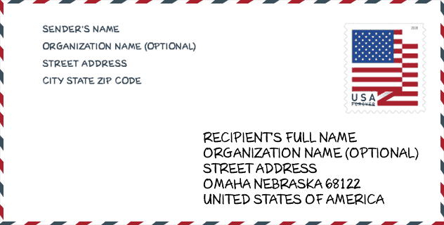
Envelop Voorbeeld

Dit is een voorbeeld van een Amerikaanse postenvelop. U kunt een 5-cijferige postcode of een gedetailleerde 9-cijferige postcode gebruiken om de mail in het volgende adresformaat te kopiëren.
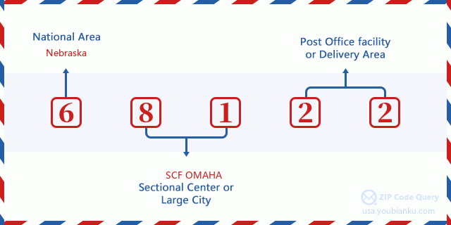
68122 Basisbetekenis
Waar staat elk cijfer van postcode 68122 voor? Het eerste cijfer geeft een nationaal gebied aan, dat varieert van nul voor het noordoosten tot negen voor het verre westen. De 2-3 cijfers zijn de code van een sectiecentrumfaciliteit in die regio. De laatste twee cijfers duiden kleine postkantoren of postzones aan.
Online landkaart

Het is een online kaart van adres Omaha, Nebraska, United States. U kunt Knopje gebruiken te in/uitzoomen. De kaartinformatie is alleen ter referentie.
Universiteit

This is the ZIP Code 68122 - University page list. Its detail university Name, Street, City, State, ZIP Code, Phone is as below.
| Naam | Straat | Stad | Staat | Postcode | Telefoon |
| CHI Health School of Radiologic Technology | 6901 North 72nd St | Omaha | NE | 68122 | (402) 572-3654 |
Ziekenhuis

Het is de Postcode 68122 - Ziekenhuis pagina lijst. Het detail Ziekenhuisnaam, straat, stad, staat, postcode, telefoon is zoals hieronder.
| Naam | Adres | Stad | Staat | Postcode | Telefoon |
|---|---|---|---|---|---|
| CHI HEALTH IMMANUEL | 6901 NORTH 72ND ST | OMAHA | NE | 68122 | (402) 572-2121 |
| NEBRASKA SPINE HOSPITAL, LLC | P O BOX 34400, 6901 NORTH 72ND ST, STE 20300 | OMAHA | NE | 68122 | (402) 572-3000 |
Population for Postcode 68122

What is the total population in ZIP Code 68122? Below is detail information.
- Population for Postcode 68122: 13,189
- 2010 Bevolking: 9,794
The 2020 demographic statistics are in progress. The current population in ZIP code 68122 is 13,189, and the population in 2010 is 9,794.
Geslacht

In all the statistical population, the male population is 4,671, the female population is 5,123.
- Male Population: 4,671
- Female Population: 5,123
Race

In all the statistical population, the male population is 4,671, the female population is 5,123.
- White Population: 7,423
- Black Population: 2,178
- Hispanic Population: 488
- Asian Population: 336
- Hawaiian Population: 28
- Indian Population: 122
- Other Population: 186
Leeftijd

In all the statistical population, the White population is 7,423, the Black population is 2,178, the Hispanic population is 488, the Asian population is 336, the Hawaiian population is 28, the Indian Ppopulation is 122 and Other population is 186.
- Age's Median: 31.4
- Median of male age: 31.1
- Median of female age: 31.6
Households for Postcode 68122
ZIP code 68122 has 3,564 households, with an average number of 2.71 persons per household. The average income per household in Zip code 68122 is 78,173 USD, and the average house value is 148,200 USD.
- Households Per Zipcode: 3,564
- Personen per huishouden: 2.71
- Gemiddelde huiswaarde: 148,200
- Inkomen per huishouden: 78,173
Geographic

The latitude of the Zip code 68122 is 41.367188, the longitude is -96.052846, and the elevation is 1169. It has land area of 19.342 square miles, and water area of 0.837 square miles. The time zone for ZIP code 68122 is Central (GMT -06:00). Daylight saving time should be observed in the area where the zip code is located.
- Breedtegraad: 41.367188
- Lengte: -96.052846
- Elevatie: 1169
- Landoppervlak: 19.342
- Water Area: 0.837
- Tijd Zone: Central (GMT -06:00)
- Regio: Midwest
- Divisie: West North Central
- Zomertijd: Y
congresdistrict

The Congressional District for ZIP code 68122 is Nebraska's 1st|2nd congressional district, the Congressional Land Area is 8879.02|509.74 square mile.
- congresdistrict: 1st|2nd
- Congresgebied: 8879.02|509.74
Levering

In the ZIP code 68122, there are 4,867 residential delivery mailboxes and centralized units, and 209 commercial delivery mailbox and centralized units, 2,485 single family deliveries and 715 multifamily deliveries, and the box count is 4,995. The main post office has city delivery carrier routes for the ZIP code 68122.
- Delivery Residential: 4,867
- Delivery Business: 209
- Delivery Total: 4,995
- Leveringseenheden voor één gezin: 2,485
- Multi Family Delivery Units: 715
- Stadsleveringsindicator: Y
Bedrijf

In ZIP code 68122, the number of business is 214, the number of employee is 4,282, the business first quarter payroll is 47,870,000 USD, the business annual payroll is 195,440,000 USD.
- Number Of Businesses: 214
- Number Of Employees: 4,282
- Zakelijke salarisadministratie eerste kwartaal: 47,870,000
- Zakelijke jaarlijkse loonlijst: 195,440,000
Sociale zekerheid

Er zijn 1,580 begunstigden met uitkeringen in de huidige betalingsstatus voor postcode 68122, waarvan 1,060 gepensioneerde werknemers, 260 gehandicapte werknemers, 65 weduwnaar (eren) en ouders, 40 zijn echtgenoten en 155 zijn kinderen. Het aantal begunstigden van 65 jaar of ouder is 1,100. De totale maandelijkse uitkeringen bedragen 2,190,000 USD, waarvan 1,631,000 USD voor gepensioneerde werknemers, 97,000 USD voor weduwnaar (eren) en ouders.
- Totaal aantal: 1,580
- Aantal gepensioneerden: 1,060
- Aantal gehandicapte werknemers: 260
- Weduwe / weduwnaar (er) en ouders Aantal: 65
- Echtgenoten nummer: 40
- Aantal kinderen: 155
- Alle begunstigden per maand: 2,190,000
- Gepensioneerde werknemers per maand: 1,631,000
- Weduwe (n) en ouders per maand: 97,000
- Aantal begunstigden van 65 jaar of ouder: 1,100


Reactie toevoegen