Verenigde Staten Postcode: 71106
Dit is de paginalijst van Louisiana Postcode 71106. Hieronder is het detail van Staat, Graafschap, Stad, Lengte, Breedtegraad, Envelop Voorbeeld, Bevolking.

Postcode 71106 Informatie

-
-
Land:
U.S. - Verenigde Staten
Staat:
Staat FIPS:
22
Netnummer:
Postcode:
71106
Postcode Type:
S (Standard)
❓Wat betekent S (Standard)? Een "standaard" postcode is waar de meeste mensen aan denken als ze het over postcodes hebben - in wezen een stad, een stad of een afdeling van een stad die een postdienst heeft.
Postcode 71106 - Stad

Dit is de stadsinformatie die overeenkomt met 71106:
| Staat | Graafschap | Stad | Stadtype ?In many cases, a ZIP Code can have multiple "names", meaning cities, towns, or subdivisions, in its boundaries. However, it will ALWAYS have exactly 1 "default" name. D - Default - This is the "preferred" name - by the USPS - for a city. Each ZIP Code has one - and only one - "default" name. In most cases, this is what people who live in that area call the city as well. A - Acceptable - This name can be used for mailing purposes. Often times alternative names are large neighborhoods or sections of the city/town. In some cases a ZIP Code may have several "acceptable" names which is used to group towns under one ZIP Code. N - Not Acceptable - A "not acceptable" name is, in many cases, a nickname that residents give that location. According to the USPS, you should NOT send mail to that ZIP Code using the "not acceptable" name when mailing. | Postcode |
|---|---|---|---|---|
| LA | Caddo | Cedar Grove | N (Not Acceptable) | 71106 |
| LA | Caddo | Forbing | A (Acceptable) | 71106 |
| LA | Caddo | Shreveport | D (Default) | 71106 |
| LA | Caddo | Spring Lake | N (Not Acceptable) | 71106 |
❓Wat betekent D (Default)? Dit is de "geprefereerde" naam - door de USPS - voor een stad. Elke postcode heeft één - en slechts één - "standaard" naam. In de meeste gevallen noemen mensen die in dat gebied wonen de stad ook.
❓Wat betekent A (Acceptable)? Deze naam kan worden gebruikt voor mailingdoeleinden. Vaak zijn alternatieve namen grote buurten of delen van de stad / stad. In sommige gevallen kan een postcode meerdere "acceptabele" namen hebben die worden gebruikt om steden onder één postcode te groeperen.
❓Wat betekent N (Not Acceptable)? Een "niet acceptabele" naam is in veel gevallen een bijnaam die bewoners aan die locatie geven. Volgens de USPS mag je GEEN post naar die postcode sturen met de "niet acceptabele" naam bij het mailen.
Postcode 71106 Plus 4
ZIP Code 5 plus 4 is de uitbreiding van de 5-cijferige postcode, het kan worden gebruikt om een meer gedetailleerde locatie te vinden. De laatste vier cijfers duiden een segment of een kant van een straat of een appartement aan. Hieronder vindt u de postcode en het bijbehorende adres van de postcode 71106.
| Postcode 5 Plus 4 | Adres |
|---|---|
| 71106-1000 | 4027 SOUTHERN AVE #A , SHREVEPORT, LA |
| 71106-1001 | 3851 RICHMOND AVE, SHREVEPORT, LA |
| 71106-1002 | 3851 RICHMOND AVE #A , SHREVEPORT, LA |
| 71106-1003 | 3806 MARYLAND AVE, SHREVEPORT, LA |
| 71106-1004 | 3806 MARYLAND AVE #A , SHREVEPORT, LA |
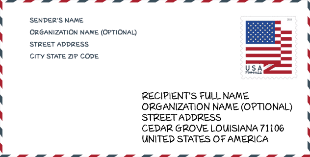
Envelop Voorbeeld

Dit is een voorbeeld van een Amerikaanse postenvelop. U kunt een 5-cijferige postcode of een gedetailleerde 9-cijferige postcode gebruiken om de mail in het volgende adresformaat te kopiëren.
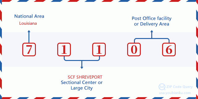
71106 Basisbetekenis
Waar staat elk cijfer van postcode 71106 voor? Het eerste cijfer geeft een nationaal gebied aan, dat varieert van nul voor het noordoosten tot negen voor het verre westen. De 2-3 cijfers zijn de code van een sectiecentrumfaciliteit in die regio. De laatste twee cijfers duiden kleine postkantoren of postzones aan.
Online landkaart

Het is een online kaart van adres Spring Lake, Louisiana, United States. U kunt Knopje gebruiken te in/uitzoomen. De kaartinformatie is alleen ter referentie.
Ziekenhuis

Het is de Postcode 71106 - Ziekenhuis pagina lijst. Het detail Ziekenhuisnaam, straat, stad, staat, postcode, telefoon is zoals hieronder.
- Naam: BRENTWOOD HOSPITAL
- Adres: SHREVEPORT
- Stad: 1006 HIGHLAND AVENUE
- Staat: LA
- Postcode: 71106
- Telefoon: (318) 678-7500
Museum

Dit is de paginalijst van Postcode 71106 - Museum. Hieronder is het detail van Museum Naam, Straat, Stad, Staat, Postcode, Telefoon.
- Naam: SHREVEPORT FIRE FIGHTERS MUSEUM
- Straat: 830 ERIE STREET
- Stad: SHREVEPORT
- Staat: LA
- Postcode: 71106
- Telefoon:
Bibliotheek

Dit is de paginalijst van Postcode 71106 - Bibliotheek. Hieronder is het detail van Bibliotheek Naam, Adres, Stad, Staat, Postcode, Telefoon.
- Naam: CEDAR GROVE & LINE AVENUE BRANCH
- Adres: 8303 LINE AVENUE
- Stad: SHREVEPORT
- Staat: LA - Louisiana
- Postcode: 71106
- Telefoon: (318) 868-3890
School

Dit is de paginalijst van Postcode 71106 - School. Hieronder is het detail van School Naam, Adres, Stad, Staat, Postcode.
| School Naam | Adres | Stad | Staat | Klassen | Postcode |
|---|---|---|---|---|---|
| Linwood Public Charter School | 401 West 70th Street | Shreveport | LA | UG | 71106 |
| Atkins Technology Elementary School | 7611 St.Vincent Avenue | Shreveport | LA | UG | 71106 |
| Eden Gardens Fundamental Elementary School | 626 Eden Boulevard | Shreveport | LA | UG | 71106 |
| Caddo Parish Middle Magnet School | 7635 Cornelious Drive | Shreveport | LA | UG | 71106 |
| Fairfield Magnet School | 6215 Fairfield Avenue | Shreveport | LA | UG | 71106 |
| Caddo Middle Career and Technology School | 6310 Clift Street | Shreveport | LA | UG | 71106 |
| South Highlands Elementary Magnet School | 831 Erie Street | Shreveport | LA | UG | 71106 |
| Woodlawn Leadership Academy | 7340 Wyngate Drive | Shreveport | LA | UG | 71106 |
Population for Postcode 71106

What is the total population in ZIP Code 71106? Below is detail information.
- Population for Postcode 71106: 38,207
- 2010 Bevolking: 34,814
The 2020 demographic statistics are in progress. The current population in ZIP code 71106 is 38,207, and the population in 2010 is 34,814.
Geslacht

In all the statistical population, the male population is 16,425, the female population is 18,389.
- Male Population: 16,425
- Female Population: 18,389
Race

In all the statistical population, the male population is 16,425, the female population is 18,389.
- White Population: 18,689
- Black Population: 15,358
- Hispanic Population: 740
- Asian Population: 545
- Hawaiian Population: 46
- Indian Population: 297
- Other Population: 369
Leeftijd

In all the statistical population, the White population is 18,689, the Black population is 15,358, the Hispanic population is 740, the Asian population is 545, the Hawaiian population is 46, the Indian Ppopulation is 297 and Other population is 369.
- Age's Median: 38.3
- Median of male age: 36.9
- Median of female age: 39.5
Households for Postcode 71106
ZIP code 71106 has 13,182 households, with an average number of 2.59 persons per household. The average income per household in Zip code 71106 is 52,755 USD, and the average house value is 232,300 USD.
- Households Per Zipcode: 13,182
- Personen per huishouden: 2.59
- Gemiddelde huiswaarde: 232,300
- Inkomen per huishouden: 52,755
Geographic

The latitude of the Zip code 71106 is 32.393759, the longitude is -93.728562, and the elevation is 195. It has land area of 32.67 square miles, and water area of 1.299 square miles. The time zone for ZIP code 71106 is Central (GMT -06:00). Daylight saving time should be observed in the area where the zip code is located.
- Breedtegraad: 32.393759
- Lengte: -93.728562
- Elevatie: 195
- Landoppervlak: 32.67
- Water Area: 1.299
- Tijd Zone: Central (GMT -06:00)
- Regio: South
- Divisie: West South Central
- Zomertijd: Y
congresdistrict

The Congressional District for ZIP code 71106 is Louisiana's 04th congressional district, the Congressional Land Area is 12435.1 square mile.
- congresdistrict: 04th
- Congresgebied: 12435.1
Levering

In the ZIP code 71106, there are 14,752 residential delivery mailboxes and centralized units, and 1,279 commercial delivery mailbox and centralized units, 12,217 single family deliveries and 1,197 multifamily deliveries, and the box count is 16,400. The main post office has city delivery carrier routes for the ZIP code 71106.
- Delivery Residential: 14,752
- Delivery Business: 1,279
- Delivery Total: 16,400
- Leveringseenheden voor één gezin: 12,217
- Multi Family Delivery Units: 1,197
- Stadsleveringsindicator: Y
Bedrijf

In ZIP code 71106, the number of business is 1,027, the number of employee is 13,941, the business first quarter payroll is 138,885,000 USD, the business annual payroll is 572,037,000 USD.
- Number Of Businesses: 1,027
- Number Of Employees: 13,941
- Zakelijke salarisadministratie eerste kwartaal: 138,885,000
- Zakelijke jaarlijkse loonlijst: 572,037,000
Sociale zekerheid

Er zijn 6,920 begunstigden met uitkeringen in de huidige betalingsstatus voor postcode 71106, waarvan 4,470 gepensioneerde werknemers, 915 gehandicapte werknemers, 570 weduwnaar (eren) en ouders, 330 zijn echtgenoten en 635 zijn kinderen. Het aantal begunstigden van 65 jaar of ouder is 5,075. De totale maandelijkse uitkeringen bedragen 9,126,000 USD, waarvan 6,641,000 USD voor gepensioneerde werknemers, 768,000 USD voor weduwnaar (eren) en ouders.
- Totaal aantal: 6,920
- Aantal gepensioneerden: 4,470
- Aantal gehandicapte werknemers: 915
- Weduwe / weduwnaar (er) en ouders Aantal: 570
- Echtgenoten nummer: 330
- Aantal kinderen: 635
- Alle begunstigden per maand: 9,126,000
- Gepensioneerde werknemers per maand: 6,641,000
- Weduwe (n) en ouders per maand: 768,000
- Aantal begunstigden van 65 jaar of ouder: 5,075


Reactie toevoegen