Verenigde Staten Postcode: 80110
Dit is de paginalijst van Colorado Postcode 80110. Hieronder is het detail van Staat, Graafschap, Stad, Lengte, Breedtegraad, Envelop Voorbeeld, Bevolking.

Postcode 80110 Informatie

-
-
Land:
U.S. - Verenigde Staten
Staat:
Staat FIPS:
08
Netnummer:
Postcode:
80110
Postcode Type:
S (Standard)
❓Wat betekent S (Standard)? Een "standaard" postcode is waar de meeste mensen aan denken als ze het over postcodes hebben - in wezen een stad, een stad of een afdeling van een stad die een postdienst heeft.
Postcode 80110 - Stad

Dit is de stadsinformatie die overeenkomt met 80110:
| Staat | Graafschap | Stad | Stadtype ?In many cases, a ZIP Code can have multiple "names", meaning cities, towns, or subdivisions, in its boundaries. However, it will ALWAYS have exactly 1 "default" name. D - Default - This is the "preferred" name - by the USPS - for a city. Each ZIP Code has one - and only one - "default" name. In most cases, this is what people who live in that area call the city as well. A - Acceptable - This name can be used for mailing purposes. Often times alternative names are large neighborhoods or sections of the city/town. In some cases a ZIP Code may have several "acceptable" names which is used to group towns under one ZIP Code. N - Not Acceptable - A "not acceptable" name is, in many cases, a nickname that residents give that location. According to the USPS, you should NOT send mail to that ZIP Code using the "not acceptable" name when mailing. | Postcode |
|---|---|---|---|---|
| CO | Arapahoe | Cherry Hills | A (Acceptable) | 80110 |
| CO | Arapahoe | Cherry Hills Village | A (Acceptable) | 80110 |
| CO | Arapahoe | Cherry Hl Vlg | A (Acceptable) | 80110 |
| CO | Arapahoe | Englewood | D (Default) | 80110 |
| CO | Arapahoe | Greenwood Village | A (Acceptable) | 80110 |
| CO | Arapahoe | Greenwood Vlg | A (Acceptable) | 80110 |
| CO | Arapahoe | Sheridan | A (Acceptable) | 80110 |
❓Wat betekent D (Default)? Dit is de "geprefereerde" naam - door de USPS - voor een stad. Elke postcode heeft één - en slechts één - "standaard" naam. In de meeste gevallen noemen mensen die in dat gebied wonen de stad ook.
❓Wat betekent A (Acceptable)? Deze naam kan worden gebruikt voor mailingdoeleinden. Vaak zijn alternatieve namen grote buurten of delen van de stad / stad. In sommige gevallen kan een postcode meerdere "acceptabele" namen hebben die worden gebruikt om steden onder één postcode te groeperen.
Postcode 80110 Plus 4
ZIP Code 5 plus 4 is de uitbreiding van de 5-cijferige postcode, het kan worden gebruikt om een meer gedetailleerde locatie te vinden. De laatste vier cijfers duiden een segment of een kant van een straat of een appartement aan. Hieronder vindt u de postcode en het bijbehorende adres van de postcode 80110.
| Postcode 5 Plus 4 | Adres |
|---|---|
| 80110-1000 | 2250 S TEJON ST, ENGLEWOOD, CO |
| 80110-1001 | 1800 W ADRIATIC PL, ENGLEWOOD, CO |
| 80110-1002 | 2101 W ADRIATIC PL, ENGLEWOOD, CO |
| 80110-1003 | 2000 W ADRIATIC PL, ENGLEWOOD, CO |
| 80110-1004 | 1801 W BAKER AVE, ENGLEWOOD, CO |
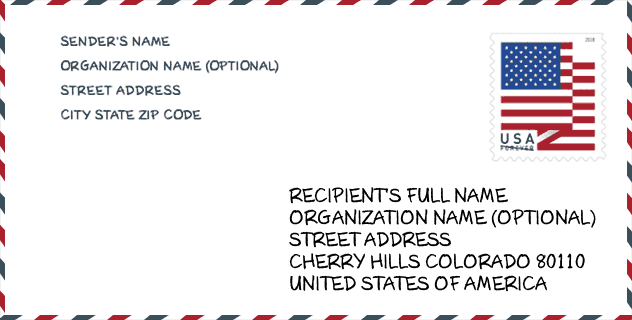
Envelop Voorbeeld

Dit is een voorbeeld van een Amerikaanse postenvelop. U kunt een 5-cijferige postcode of een gedetailleerde 9-cijferige postcode gebruiken om de mail in het volgende adresformaat te kopiëren.
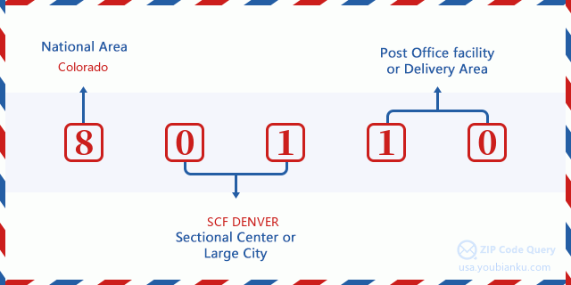
80110 Basisbetekenis
Waar staat elk cijfer van postcode 80110 voor? Het eerste cijfer geeft een nationaal gebied aan, dat varieert van nul voor het noordoosten tot negen voor het verre westen. De 2-3 cijfers zijn de code van een sectiecentrumfaciliteit in die regio. De laatste twee cijfers duiden kleine postkantoren of postzones aan.
Online landkaart

Het is een online kaart van adres Sheridan, Colorado, United States. U kunt Knopje gebruiken te in/uitzoomen. De kaartinformatie is alleen ter referentie.
Museum

Dit is de paginalijst van Postcode 80110 - Museum. Hieronder is het detail van Museum Naam, Straat, Stad, Staat, Postcode, Telefoon.
- Naam: ENGLEWOOD HISTORICAL SOCIETY
- Straat: 1000 ENGLEWOOD PKWY
- Stad: ENGLEWOOD
- Staat: CO
- Postcode: 80110
- Telefoon: (303) 783-6956
Bibliotheek

Dit is de paginalijst van Postcode 80110 - Bibliotheek. Hieronder is het detail van Bibliotheek Naam, Adres, Stad, Staat, Postcode, Telefoon.
- Naam: ENGLEWOOD PUBLIC LIBRARY
- Adres: 1000 ENGLEWOOD PARKWAY
- Stad: ENGLEWOOD
- Staat: CO - Colorado
- Postcode: 80110
- Telefoon: (303) 762-2560
School

Dit is de paginalijst van Postcode 80110 - School. Hieronder is het detail van School Naam, Adres, Stad, Staat, Postcode.
- School Naam: Wm E Bishop Elementary School
- Adres: 3100 S ELATI ST
- Stad: ENGLEWOOD
- Staat: CO
- Klassen: UG
- Postcode: 80110
Population for Postcode 80110

What is the total population in ZIP Code 80110? Below is detail information.
- Population for Postcode 80110: 24,234
- 2010 Bevolking: 20,867
The 2020 demographic statistics are in progress. The current population in ZIP code 80110 is 24,234, and the population in 2010 is 20,867.
Geslacht

In all the statistical population, the male population is 10,723, the female population is 10,144.
- Male Population: 10,723
- Female Population: 10,144
Race

In all the statistical population, the male population is 10,723, the female population is 10,144.
- White Population: 17,253
- Black Population: 761
- Hispanic Population: 5,799
- Asian Population: 626
- Hawaiian Population: 56
- Indian Population: 631
- Other Population: 2,421
Leeftijd

In all the statistical population, the White population is 17,253, the Black population is 761, the Hispanic population is 5,799, the Asian population is 626, the Hawaiian population is 56, the Indian Ppopulation is 631 and Other population is 2,421.
- Age's Median: 34.7
- Median of male age: 33.7
- Median of female age: 35.9
Households for Postcode 80110
ZIP code 80110 has 8,776 households, with an average number of 2.36 persons per household. The average income per household in Zip code 80110 is 56,789 USD, and the average house value is 258,200 USD.
- Households Per Zipcode: 8,776
- Personen per huishouden: 2.36
- Gemiddelde huiswaarde: 258,200
- Inkomen per huishouden: 56,789
Geographic

The latitude of the Zip code 80110 is 39.649278, the longitude is -105.011248, and the elevation is 5268. It has land area of 6.347 square miles, and water area of 0.155 square miles. The time zone for ZIP code 80110 is Mountain (GMT -07:00). Daylight saving time should be observed in the area where the zip code is located.
- Breedtegraad: 39.649278
- Lengte: -105.011248
- Elevatie: 5268
- Landoppervlak: 6.347
- Water Area: 0.155
- Tijd Zone: Mountain (GMT -07:00)
- Regio: West
- Divisie: Mountain
- Zomertijd: Y
congresdistrict

The Congressional District for ZIP code 80110 is Colorado's 1st congressional district, the Congressional Land Area is 189.62 square mile.
- congresdistrict: 1st
- Congresgebied: 189.62
Levering

In the ZIP code 80110, there are 10,269 residential delivery mailboxes and centralized units, and 1,952 commercial delivery mailbox and centralized units, 6,232 single family deliveries and 3,214 multifamily deliveries, and the box count is 17,846. The main post office has city delivery carrier routes for the ZIP code 80110.
- Delivery Residential: 10,269
- Delivery Business: 1,952
- Delivery Total: 17,846
- Leveringseenheden voor één gezin: 6,232
- Multi Family Delivery Units: 3,214
- Stadsleveringsindicator: Y
Bedrijf

In ZIP code 80110, the number of business is 1,558, the number of employee is 23,427, the business first quarter payroll is 296,963,000 USD, the business annual payroll is 1,217,297,000 USD.
- Number Of Businesses: 1,558
- Number Of Employees: 23,427
- Zakelijke salarisadministratie eerste kwartaal: 296,963,000
- Zakelijke jaarlijkse loonlijst: 1,217,297,000
Sociale zekerheid

Er zijn 3,210 begunstigden met uitkeringen in de huidige betalingsstatus voor postcode 80110, waarvan 2,235 gepensioneerde werknemers, 500 gehandicapte werknemers, 170 weduwnaar (eren) en ouders, 100 zijn echtgenoten en 205 zijn kinderen. Het aantal begunstigden van 65 jaar of ouder is 2,375. De totale maandelijkse uitkeringen bedragen 4,291,000 USD, waarvan 3,228,000 USD voor gepensioneerde werknemers, 224,000 USD voor weduwnaar (eren) en ouders.
- Totaal aantal: 3,210
- Aantal gepensioneerden: 2,235
- Aantal gehandicapte werknemers: 500
- Weduwe / weduwnaar (er) en ouders Aantal: 170
- Echtgenoten nummer: 100
- Aantal kinderen: 205
- Alle begunstigden per maand: 4,291,000
- Gepensioneerde werknemers per maand: 3,228,000
- Weduwe (n) en ouders per maand: 224,000
- Aantal begunstigden van 65 jaar of ouder: 2,375


Reactie toevoegen