Verenigde Staten Postcode: 87004
Dit is de paginalijst van New Mexico Postcode 87004. Hieronder is het detail van Staat, Graafschap, Stad, Lengte, Breedtegraad, Envelop Voorbeeld, Bevolking.

Postcode 87004 Informatie

-
-
Land:
U.S. - Verenigde Staten
Staat:
Staat FIPS:
35
Netnummer:
Postcode:
87004
Postcode Type:
S (Standard)
❓Wat betekent S (Standard)? Een "standaard" postcode is waar de meeste mensen aan denken als ze het over postcodes hebben - in wezen een stad, een stad of een afdeling van een stad die een postdienst heeft.
Postcode 87004 - Stad

Dit is de stadsinformatie die overeenkomt met 87004:
| Staat | Graafschap | Stad | Stadtype ?In many cases, a ZIP Code can have multiple "names", meaning cities, towns, or subdivisions, in its boundaries. However, it will ALWAYS have exactly 1 "default" name. D - Default - This is the "preferred" name - by the USPS - for a city. Each ZIP Code has one - and only one - "default" name. In most cases, this is what people who live in that area call the city as well. A - Acceptable - This name can be used for mailing purposes. Often times alternative names are large neighborhoods or sections of the city/town. In some cases a ZIP Code may have several "acceptable" names which is used to group towns under one ZIP Code. N - Not Acceptable - A "not acceptable" name is, in many cases, a nickname that residents give that location. According to the USPS, you should NOT send mail to that ZIP Code using the "not acceptable" name when mailing. | Postcode |
|---|---|---|---|---|
| NM | Sandoval | Bernalillo | D (Default) | 87004 |
| NM | Sandoval | El Llanito | N (Not Acceptable) | 87004 |
| NM | Sandoval | Ranchitos | N (Not Acceptable) | 87004 |
| NM | Sandoval | Sandia Pueblo | A (Acceptable) | 87004 |
| NM | Sandoval | Santa Ana Pue | A (Acceptable) | 87004 |
| NM | Sandoval | Santa Ana Pueblo | A (Acceptable) | 87004 |
| NM | Sandoval | Tamaya | A (Acceptable) | 87004 |
❓Wat betekent D (Default)? Dit is de "geprefereerde" naam - door de USPS - voor een stad. Elke postcode heeft één - en slechts één - "standaard" naam. In de meeste gevallen noemen mensen die in dat gebied wonen de stad ook.
❓Wat betekent A (Acceptable)? Deze naam kan worden gebruikt voor mailingdoeleinden. Vaak zijn alternatieve namen grote buurten of delen van de stad / stad. In sommige gevallen kan een postcode meerdere "acceptabele" namen hebben die worden gebruikt om steden onder één postcode te groeperen.
❓Wat betekent N (Not Acceptable)? Een "niet acceptabele" naam is in veel gevallen een bijnaam die bewoners aan die locatie geven. Volgens de USPS mag je GEEN post naar die postcode sturen met de "niet acceptabele" naam bij het mailen.
Postcode 87004 Plus 4
ZIP Code 5 plus 4 is de uitbreiding van de 5-cijferige postcode, het kan worden gebruikt om een meer gedetailleerde locatie te vinden. De laatste vier cijfers duiden een segment of een kant van een straat of een appartement aan. Hieronder vindt u de postcode en het bijbehorende adres van de postcode 87004.
| Postcode 5 Plus 4 | Adres |
|---|---|
| 87004-0001 | PO BOX 1, BERNALILLO, NM |
| 87004-0040 | PO BOX 40, BERNALILLO, NM |
| 87004-0041 | PO BOX 41, BERNALILLO, NM |
| 87004-0121 | PO BOX 121, BERNALILLO, NM |
| 87004-0241 | PO BOX 241, BERNALILLO, NM |
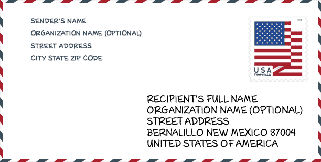
Envelop Voorbeeld

Dit is een voorbeeld van een Amerikaanse postenvelop. U kunt een 5-cijferige postcode of een gedetailleerde 9-cijferige postcode gebruiken om de mail in het volgende adresformaat te kopiëren.
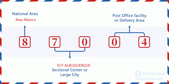
87004 Basisbetekenis
Waar staat elk cijfer van postcode 87004 voor? Het eerste cijfer geeft een nationaal gebied aan, dat varieert van nul voor het noordoosten tot negen voor het verre westen. De 2-3 cijfers zijn de code van een sectiecentrumfaciliteit in die regio. De laatste twee cijfers duiden kleine postkantoren of postzones aan.
Online landkaart

Het is een online kaart van adres Tamaya, New Mexico, United States. U kunt Knopje gebruiken te in/uitzoomen. De kaartinformatie is alleen ter referentie.
Museum

Dit is de paginalijst van Postcode 87004 - Museum. Hieronder is het detail van Museum Naam, Straat, Stad, Staat, Postcode, Telefoon.
- Naam: SANDOVAL COUNTY HISTORICAL SOCIETY
- Straat: PO BOX 692
- Stad: BERNALILLO
- Staat: NM
- Postcode: 87004
- Telefoon: (505) 867-5872
Bibliotheek

Dit is de paginalijst van Postcode 87004 - Bibliotheek. Hieronder is het detail van Bibliotheek Naam, Adres, Stad, Staat, Postcode, Telefoon.
| Naam | Adres | Stad | Staat | Postcode | Telefoon |
|---|---|---|---|---|---|
| PUEBLO OF SANDIA LEARNING RESOURCE CENTER | 236 SANDIA DAY SCHOOL ROAD | SANDIA PUEBLO | NM | 87004 | (505) 771-5074 |
| SANTA ANA PUEBLO COMMUNITY LIBRARY | 2 DOVE ROAD | SANTA ANA | NM | 87004 | (505) 771-6736 |
| TOWN OF BERNALILLO PUBLIC LIBRARY | 124 CALLE MALINCHE | BERNALILLO | NM | 87004 | (505) 867-1440 |
School

Dit is de paginalijst van Postcode 87004 - School. Hieronder is het detail van School Naam, Adres, Stad, Staat, Postcode.
| School Naam | Adres | Stad | Staat | Klassen | Postcode |
|---|---|---|---|---|---|
| BERNALILLO HIGH | 250 ISIDRO SANCHEZ RD | BERNALILLO | NM | UG | 87004 |
| BERNALILLO MIDDLE | 485 CAMINO DON TOMAS | BERNALILLO | NM | UG | 87004 |
| PLACITAS ELEMENTARY | 5 CALLE DEL CARBON | BERNALILLO | NM | UG | 87004 |
| BERNALILLO ELEMENTARY | 301 CALLE DEL CARBON | BERNALILLO | NM | UG | 87004 |
| WD CARROLL ELEMENTARY | 842 CAMINO DON TOMAS | BERNALILLO | NM | UG | 87004 |
| LA ESCUELITA EARLY CHILDHOOD | 301 CALLE DE ESCUELA | BERNALILLO | NM | UG | 87004 |
Population for Postcode 87004

What is the total population in ZIP Code 87004? Below is detail information.
- Population for Postcode 87004: 10,075
- 2010 Bevolking: 10,136
The 2020 demographic statistics are in progress. The current population in ZIP code 87004 is 10,075, and the population in 2010 is 10,136.
Geslacht

In all the statistical population, the male population is 5,099, the female population is 5,037.
- Male Population: 5,099
- Female Population: 5,037
Race

In all the statistical population, the male population is 5,099, the female population is 5,037.
- White Population: 5,849
- Black Population: 108
- Hispanic Population: 6,508
- Asian Population: 63
- Hawaiian Population: 25
- Indian Population: 1,520
- Other Population: 2,802
Leeftijd

In all the statistical population, the White population is 5,849, the Black population is 108, the Hispanic population is 6,508, the Asian population is 63, the Hawaiian population is 25, the Indian Ppopulation is 1,520 and Other population is 2,802.
- Age's Median: 38.2
- Median of male age: 36.9
- Median of female age: 39.6
Households for Postcode 87004
ZIP code 87004 has 3,552 households, with an average number of 2.71 persons per household. The average income per household in Zip code 87004 is 43,333 USD, and the average house value is 153,500 USD.
- Households Per Zipcode: 3,552
- Personen per huishouden: 2.71
- Gemiddelde huiswaarde: 153,500
- Inkomen per huishouden: 43,333
Geographic

The latitude of the Zip code 87004 is 35.383335, the longitude is -106.635767, and the elevation is 5523. It has land area of 57.067 square miles, and water area of 0.386 square miles. The time zone for ZIP code 87004 is Mountain (GMT -07:00). Daylight saving time should be observed in the area where the zip code is located.
- Breedtegraad: 35.383335
- Lengte: -106.635767
- Elevatie: 5523
- Landoppervlak: 57.067
- Water Area: 0.386
- Tijd Zone: Mountain (GMT -07:00)
- Regio: West
- Divisie: Mountain
- Zomertijd: Y
congresdistrict

The Congressional District for ZIP code 87004 is New Mexico's 1st|3rd congressional district, the Congressional Land Area is 4600.14|44958.52 square mile.
- congresdistrict: 1st|3rd
- Congresgebied: 4600.14|44958.52
Levering

In the ZIP code 87004, there are 3,718 residential delivery mailboxes and centralized units, and 253 commercial delivery mailbox and centralized units, 51 single family deliveries and 37 multifamily deliveries, and the box count is 6,698. The main post office does not have city delivery carrier routes for the ZIP code 87004.
- Delivery Residential: 3,718
- Delivery Business: 253
- Delivery Total: 6,698
- Leveringseenheden voor één gezin: 51
- Multi Family Delivery Units: 37
- Stadsleveringsindicator: N
Bedrijf

In ZIP code 87004, the number of business is 195, the number of employee is 3,555, the business first quarter payroll is 23,879,000 USD, the business annual payroll is 108,188,000 USD.
- Number Of Businesses: 195
- Number Of Employees: 3,555
- Zakelijke salarisadministratie eerste kwartaal: 23,879,000
- Zakelijke jaarlijkse loonlijst: 108,188,000
Sociale zekerheid

Er zijn 2,930 begunstigden met uitkeringen in de huidige betalingsstatus voor postcode 87004, waarvan 2,065 gepensioneerde werknemers, 425 gehandicapte werknemers, 185 weduwnaar (eren) en ouders, 110 zijn echtgenoten en 145 zijn kinderen. Het aantal begunstigden van 65 jaar of ouder is 2,240. De totale maandelijkse uitkeringen bedragen 3,958,000 USD, waarvan 3,006,000 USD voor gepensioneerde werknemers, 237,000 USD voor weduwnaar (eren) en ouders.
- Totaal aantal: 2,930
- Aantal gepensioneerden: 2,065
- Aantal gehandicapte werknemers: 425
- Weduwe / weduwnaar (er) en ouders Aantal: 185
- Echtgenoten nummer: 110
- Aantal kinderen: 145
- Alle begunstigden per maand: 3,958,000
- Gepensioneerde werknemers per maand: 3,006,000
- Weduwe (n) en ouders per maand: 237,000
- Aantal begunstigden van 65 jaar of ouder: 2,240


Reactie toevoegen