Verenigde Staten Postcode: 96960
Dit is de paginalijst van Marshall Islands Postcode 96960. Hieronder is het detail van Staat, Graafschap, Stad, Lengte, Breedtegraad, Envelop Voorbeeld, Bevolking.

Postcode 96960 Informatie

-
-
Land:
U.S. - Verenigde Staten
Staat:
Staat FIPS:
68
Netnummer:
Postcode:
96960
Postcode Type:
P (PO Box Only)
❓Wat betekent P (PO Box Only)? Plattelandssteden, groepen steden of zelfs snelgroeiende gebieden van steden krijgen een postcode van het type "Alleen postbus".
Postcode 96960 - Stad

Dit is de stadsinformatie die overeenkomt met 96960:
| Staat | Graafschap | Stad | Stadtype ?In many cases, a ZIP Code can have multiple "names", meaning cities, towns, or subdivisions, in its boundaries. However, it will ALWAYS have exactly 1 "default" name. D - Default - This is the "preferred" name - by the USPS - for a city. Each ZIP Code has one - and only one - "default" name. In most cases, this is what people who live in that area call the city as well. A - Acceptable - This name can be used for mailing purposes. Often times alternative names are large neighborhoods or sections of the city/town. In some cases a ZIP Code may have several "acceptable" names which is used to group towns under one ZIP Code. N - Not Acceptable - A "not acceptable" name is, in many cases, a nickname that residents give that location. According to the USPS, you should NOT send mail to that ZIP Code using the "not acceptable" name when mailing. | Postcode |
|---|---|---|---|---|
| MH | Marshall Islands | Majuro | D (Default) | 96960 |
| MH | Marshall Islands | Majuro Marshall Islands | N (Not Acceptable) | 96960 |
❓Wat betekent D (Default)? Dit is de "geprefereerde" naam - door de USPS - voor een stad. Elke postcode heeft één - en slechts één - "standaard" naam. In de meeste gevallen noemen mensen die in dat gebied wonen de stad ook.
❓Wat betekent N (Not Acceptable)? Een "niet acceptabele" naam is in veel gevallen een bijnaam die bewoners aan die locatie geven. Volgens de USPS mag je GEEN post naar die postcode sturen met de "niet acceptabele" naam bij het mailen.
Postcode 96960 Plus 4
ZIP Code 5 plus 4 is de uitbreiding van de 5-cijferige postcode, het kan worden gebruikt om een meer gedetailleerde locatie te vinden. De laatste vier cijfers duiden een segment of een kant van een straat of een appartement aan. Hieronder vindt u de postcode en het bijbehorende adres van de postcode 96960.
| Postcode 5 Plus 4 | Adres |
|---|---|
| 96960-0001 | PO BOX 1, MAJURO, MH |
| 96960-0021 | PO BOX 21, MAJURO, MH |
| 96960-0081 | PO BOX 81, MAJURO, MH |
| 96960-0141 | PO BOX 141, MAJURO, MH |
| 96960-0201 | PO BOX 201, MAJURO, MH |
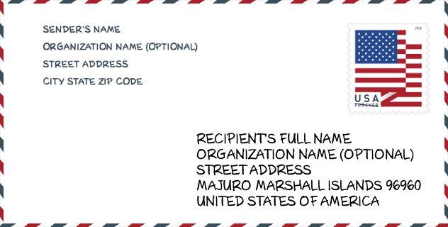
Envelop Voorbeeld

Dit is een voorbeeld van een Amerikaanse postenvelop. U kunt een 5-cijferige postcode of een gedetailleerde 9-cijferige postcode gebruiken om de mail in het volgende adresformaat te kopiëren.
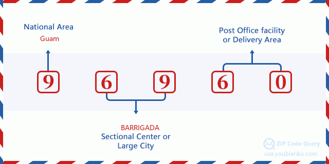
96960 Basisbetekenis
Waar staat elk cijfer van postcode 96960 voor? Het eerste cijfer geeft een nationaal gebied aan, dat varieert van nul voor het noordoosten tot negen voor het verre westen. De 2-3 cijfers zijn de code van een sectiecentrumfaciliteit in die regio. De laatste twee cijfers duiden kleine postkantoren of postzones aan.
Online landkaart

Het is een online kaart van adres Majuro Marshall Islands, Marshall Islands, United States. U kunt Knopje gebruiken te in/uitzoomen. De kaartinformatie is alleen ter referentie.
Universiteit

This is the ZIP Code 96960 - University page list. Its detail university Name, Street, City, State, ZIP Code, Phone is as below.
| Naam | Straat | Stad | Staat | Postcode | Telefoon |
| College of the Marshall Islands | Oceanside Uliga - PO Box 1258 | Majuro | MH | 96960 | (692) 625-3394 x236 |
Geographic

The latitude of the Zip code 96960 is 7.080122, the longitude is -171.156851, and the elevation is 0. It has land area of 0 square miles, and water area of 0 square miles. The time zone for ZIP code 96960 is Marshall Islands (GMT +12:00). Daylight saving time should be observed in the area where the zip code is located.
- Breedtegraad: 7.080122
- Lengte: -171.156851
- Elevatie: 0
- Landoppervlak: 0
- Water Area: 0
- Tijd Zone: Marshall Islands (GMT +12:00)
- Zomertijd: N
Levering

In the ZIP code 96960, there are 0 residential delivery mailboxes and centralized units, and 0 commercial delivery mailbox and centralized units, 0 single family deliveries and 0 multifamily deliveries, and the box count is 1,942. The main post office does not have city delivery carrier routes for the ZIP code 96960.
- Delivery Residential: 0
- Delivery Business: 0
- Delivery Total: 1,942
- Leveringseenheden voor één gezin: 0
- Multi Family Delivery Units: 0
- Stadsleveringsindicator: N


Reactie toevoegen