ZIP Code: 01604, Worcester, MA
ZIP Code 01604 is located in Worcester, Massachusetts. Its detail State, County, City, Longitude, Latitude, Envelope Example, Population is as below.
ZIP Code 01604 Information

-
-
Country:
U.S. - United States
State:
County FIPS:
25027
City:
Area Code:
City Type ?In many cases, a ZIP Code can have multiple "names", meaning cities, towns, or subdivisions, in its boundaries. However, it will ALWAYS have exactly 1 "default" name. D - Default - This is the "preferred" name - by the USPS - for a city. Each ZIP Code has one - and only one - "default" name. In most cases, this is what people who live in that area call the city as well. A - Acceptable - This name can be used for mailing purposes. Often times alternative names are large neighborhoods or sections of the city/town. In some cases a ZIP Code may have several "acceptable" names which is used to group towns under one ZIP Code. N - Not Acceptable - A "not acceptable" name is, in many cases, a nickname that residents give that location. According to the USPS, you should NOT send mail to that ZIP Code using the "not acceptable" name when mailing.:
D (Default)
ZIP Code:
01604
❓What does D (Default) mean? This is the "preferred" name - by the USPS - for a city. Each ZIP Code has one - and only one - "default" name. In most cases, this is what people who live in that area call the city as well.
ZIP Code 01604 Plus 4
ZIP Code 5 plus 4 is the extension of 5-digit zip code, It can be used to locate a more detailed location. The last four digits designate segment or one side of a street or an apartment. You can find the ZIP+4 code and corresponding address of the zip code 01604 below.
| ZIP Code 5 Plus 4 | Address |
|---|---|
| 01604-1000 | 61 FRANK ST #00000011 , WORCESTER, MA |
| 01604-1000 | 61 FRANK ST #00000036 , WORCESTER, MA |
| 01604-1001 | 403 BELMONT ST, WORCESTER, MA |
| 01604-1002 | 67 FRANK ST #00000176 , WORCESTER, MA |
| 01604-1003 | 401 BELMONT ST, WORCESTER, MA |
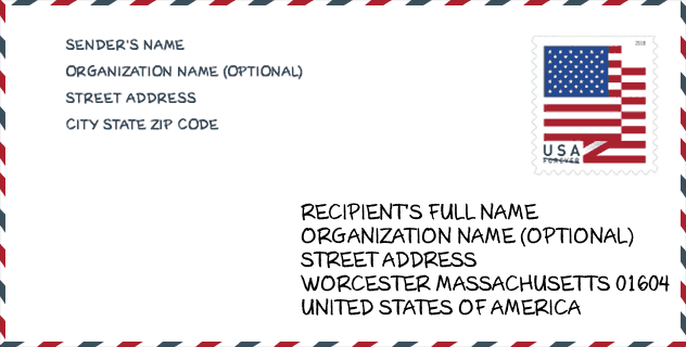
Envelope Example

This is an example of a US zip envelope. You can use a 5-digit zipcode or a detailed 9-digit zipcode to copy the mail in the following address format.
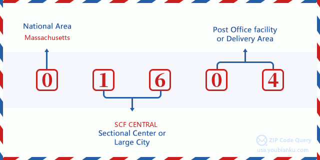
01604 Basic Meaning
What does each digit of ZIP Code 01604 stands for? The first digit designates a national area, which ranges from zero for the Northeast to nine for the far West. The 2-3 digits are the code of a sectional center facility in that region. The last two digits designate small post offices or postal zones.
Online Map

This is online map of the address Worcester, Massachusetts, United States. You may use button to move and zoom in / out. The map information is for reference only.
University

This is the ZIP Code 01604 - University page list. Its detail university Name, Street, City, State, ZIP Code, Phone is as below.
| Name | Street | City | State | ZIP Code | Phone |
| Bancroft School of Massage Therapy | 333 Shrewsbury St | Worcester | MA | 01604 | (508) 757-7923 |
Hospital

This is the ZIP Code 01604 - Hospital page list. Its detail Hospital Name, Street, City, State, ZIP Code, Phone is as below.
- Name: WORCESTER RECOVERY CENTER AND HOSPITAL
- Address: WORCESTER
- City: 309 BELMONT STREET
- State: MA
- ZIP Code: 01604
- Phone: (508) 752-4681
Museum

This is the ZIP Code 01604 - Museum page list. Its detail Museum Name, Street, City, State, ZIP Code, Phone is as below.
| Name | Street | City | State | ZIP Code | Phone |
| MASS AUDUBON CENTRAL SANCTUARIES | 414 MASSASOIT RD | WORCESTER | MA | 01604 | (508) 753-6087 |
| ECOTARIUM | 222 HARRINGTON WAY | WORCESTER | MA | 01604 | (508) 929-2700 |
Library

This is the ZIP Code 01604 - Library page list. Its detail Library Name, Address, City, State, ZIP Code, Phone is as below.
- Name: ROOSEVELT BRANCH
- Address: 1006 GRAFTON STREET
- City: WORCESTER
- State: MA - Massachusetts
- ZIP Code: 01604
- Phone: (508) 799-8327
School
This is the ZIP Code 01604 - School page list. Its detail School Name, Address, City, State, ZIP Code is as below.
| School Name | Address | City | State | Grades | ZIP Code |
|---|---|---|---|---|---|
| Grafton Street | 311 Grafton Street | Worcester | MA | UG | 01604 |
| Lake View | 133 Coburn Avenue | Worcester | MA | UG | 01604 |
| North High | 140 Harrington Way | Worcester | MA | UG | 01604 |
| Rice Square | 76 Massasoit Rd | Worcester | MA | UG | 01604 |
| Roosevelt | 1006 Grafton Street | Worcester | MA | UG | 01604 |
| Union Hill School | 1 Chapin Street | Worcester | MA | UG | 01604 |
| Worcester East Middle | 420 Grafton Street | Worcester | MA | UG | 01604 |
| La Familia Dual Language School | 355 Grafton Street | Worcester | MA | UG | 01604 |
Population for ZIP Code 01604

What is the total population in ZIP Code 01604? Below is detail information.
- Population for ZIP Code 01604: 35,836
- 2010 Population: 34,677
The 2020 demographic statistics are in progress. The current population in ZIP code 01604 is 35,836, and the population in 2010 is 34,677.
Gender

In all the statistical population, the male population is 16,835, the female population is 17,842.
- Male Population: 16,835
- Female Population: 17,842
Race

In all the statistical population, the male population is 16,835, the female population is 17,842.
- White Population: 25,893
- Black Population: 4,612
- Hispanic Population: 5,823
- Asian Population: 2,265
- Hawaiian Population: 84
- Indian Population: 310
- Other Population: 2,962
Age

In all the statistical population, the White population is 25,893, the Black population is 4,612, the Hispanic population is 5,823, the Asian population is 2,265, the Hawaiian population is 84, the Indian Ppopulation is 310 and Other population is 2,962.
- Age's Median: 35.7
- Median of male age: 34.4
- Median of female age: 37.0
Households for ZIP Code 01604
ZIP code 01604 has 14,293 households, with an average number of 2.40 persons per household. The average income per household in Zip code 01604 is 53,270 USD, and the average house value is 219,100 USD.
- Households Per Zipcode: 14,293
- Persons Per Household: 2.40
- Average House Value: 219,100
- Income Per Household: 53,270
Geographic

The latitude of the Zip code 01604 is 42.249198, the longitude is -71.764908, and the elevation is 554. It has land area of 6.439 square miles, and water area of 0.184 square miles. The time zone for ZIP code 01604 is Eastern (GMT -05:00). Daylight saving time should be observed in the area where the zip code is located.
- Latitude: 42.249198
- Longitude: -71.764908
- Elevation: 554
- Land Area: 6.439
- Water Area: 0.184
- Time Zone: Eastern (GMT -05:00)
- Region: Northeast
- Division: New England
- Day Light Saving: Y
Congressional District

The Congressional District for ZIP code 01604 is Massachusetts's 2nd congressional district, the Congressional Land Area is 1628 square mile.
- Congressional District: 2nd
- Congressional Land Area: 1628
Delivery

In the ZIP code 01604, there are 14,932 residential delivery mailboxes and centralized units, and 1,079 commercial delivery mailbox and centralized units, 9,754 single family deliveries and 3,491 multifamily deliveries, and the box count is 16,445. The main post office has city delivery carrier routes for the ZIP code 01604.
- Delivery Residential: 14,932
- Delivery Business: 1,079
- Delivery Total: 16,445
- Single Family Delivery Units: 9,754
- Multi Family Delivery Units: 3,491
- City Delivery Indicator: Y
Business

In ZIP code 01604, the number of business is 716, the number of employee is 9,471, the business first quarter payroll is 89,901,000 USD, the business annual payroll is 383,016,000 USD.
- Number Of Businesses: 716
- Number Of Employees: 9,471
- Business First Quarter Payroll: 89,901,000
- Business Annual Payroll: 383,016,000


Add new comment