ZIP Code: 01605, Worcester, MA
ZIP Code 01605 is located in Worcester, Massachusetts. Its detail State, County, City, Longitude, Latitude, Envelope Example, Population is as below.
ZIP Code 01605 Information

-
-
Country:
U.S. - United States
State:
County FIPS:
25027
City:
Area Code:
City Type ?In many cases, a ZIP Code can have multiple "names", meaning cities, towns, or subdivisions, in its boundaries. However, it will ALWAYS have exactly 1 "default" name. D - Default - This is the "preferred" name - by the USPS - for a city. Each ZIP Code has one - and only one - "default" name. In most cases, this is what people who live in that area call the city as well. A - Acceptable - This name can be used for mailing purposes. Often times alternative names are large neighborhoods or sections of the city/town. In some cases a ZIP Code may have several "acceptable" names which is used to group towns under one ZIP Code. N - Not Acceptable - A "not acceptable" name is, in many cases, a nickname that residents give that location. According to the USPS, you should NOT send mail to that ZIP Code using the "not acceptable" name when mailing.:
D (Default)
ZIP Code:
01605
❓What does D (Default) mean? This is the "preferred" name - by the USPS - for a city. Each ZIP Code has one - and only one - "default" name. In most cases, this is what people who live in that area call the city as well.
ZIP Code 01605 Plus 4
ZIP Code 5 plus 4 is the extension of 5-digit zip code, It can be used to locate a more detailed location. The last four digits designate segment or one side of a street or an apartment. You can find the ZIP+4 code and corresponding address of the zip code 01605 below.
| ZIP Code 5 Plus 4 | Address |
|---|---|
| 01605-0001 | PO BOX 7001, WORCESTER, MA |
| 01605-0121 | PO BOX 7121, WORCESTER, MA |
| 01605-0241 | PO BOX 7241, WORCESTER, MA |
| 01605-0361 | PO BOX 7361, WORCESTER, MA |
| 01605-0421 | PO BOX 7421, WORCESTER, MA |
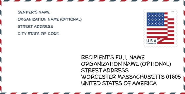
Envelope Example

This is an example of a US zip envelope. You can use a 5-digit zipcode or a detailed 9-digit zipcode to copy the mail in the following address format.
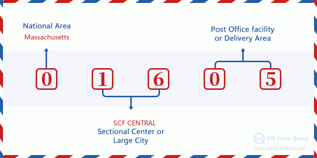
01605 Basic Meaning
What does each digit of ZIP Code 01605 stands for? The first digit designates a national area, which ranges from zero for the Northeast to nine for the far West. The 2-3 digits are the code of a sectional center facility in that region. The last two digits designate small post offices or postal zones.
Online Map

This is online map of the address Worcester, Massachusetts, United States. You may use button to move and zoom in / out. The map information is for reference only.
Hospital

This is the ZIP Code 01605 - Hospital page list. Its detail Hospital Name, Street, City, State, ZIP Code, Phone is as below.
- Name: ADCARE HOSPITAL OF WORCESTER INC
- Address: WORCESTER
- City: 107 LINCOLN STREET
- State: MA
- ZIP Code: 01605
- Phone: (508) 799-9000
Library

This is the ZIP Code 01605 - Library page list. Its detail Library Name, Address, City, State, ZIP Code, Phone is as below.
- Name: GREAT BROOK VALLEY BRANCH LIBRARY
- Address: 89 TACOMA STREET
- City: WORCESTER
- State: MA - Massachusetts
- ZIP Code: 01605
- Phone: (508) 799-1729
School

This is the ZIP Code 01605 - School page list. Its detail School Name, Address, City, State, ZIP Code is as below.
| School Name | Address | City | State | Grades | ZIP Code |
|---|---|---|---|---|---|
| Ma Academy for Math and Science School | 85 Prescott Street | Worcester | MA | UG | 01605 |
| Learning First Charter Public School | 51 Gage Street | Worcester | MA | UG | 01605 |
| Belmont Street Community | 170 Belmont Street | Worcester | MA | UG | 01605 |
| Forest Grove Middle | 495 Grove Street | Worcester | MA | UG | 01605 |
| Francis J McGrath Elementary | 493 Grove Street | Worcester | MA | UG | 01605 |
| Lincoln Street | 549 Lincoln Street | Worcester | MA | UG | 01605 |
| Nelson Place | 35 Nelson Pl | Worcester | MA | UG | 01605 |
| Wawecus Road School | 20 Wawecus Rd | Worcester | MA | UG | 01605 |
| Worcester Technical High | 1 Skyline Drive | Worcester | MA | UG | 01605 |
| City View | 80 Prospect Street | Worcester | MA | UG | 01605 |
Population for ZIP Code 01605

What is the total population in ZIP Code 01605? Below is detail information.
- Population for ZIP Code 01605: 26,924
- 2010 Population: 26,221
The 2020 demographic statistics are in progress. The current population in ZIP code 01605 is 26,924, and the population in 2010 is 26,221.
Gender

In all the statistical population, the male population is 12,190, the female population is 14,031.
- Male Population: 12,190
- Female Population: 14,031
Race

In all the statistical population, the male population is 12,190, the female population is 14,031.
- White Population: 17,449
- Black Population: 5,160
- Hispanic Population: 7,589
- Asian Population: 1,359
- Hawaiian Population: 30
- Indian Population: 354
- Other Population: 3,225
Age

In all the statistical population, the White population is 17,449, the Black population is 5,160, the Hispanic population is 7,589, the Asian population is 1,359, the Hawaiian population is 30, the Indian Ppopulation is 354 and Other population is 3,225.
- Age's Median: 33.2
- Median of male age: 31.3
- Median of female age: 34.9
Households for ZIP Code 01605
ZIP code 01605 has 10,272 households, with an average number of 2.49 persons per household. The average income per household in Zip code 01605 is 37,857 USD, and the average house value is 213,300 USD.
- Households Per Zipcode: 10,272
- Persons Per Household: 2.49
- Average House Value: 213,300
- Income Per Household: 37,857
Geographic

The latitude of the Zip code 01605 is 42.288915, the longitude is -71.795780, and the elevation is 537. It has land area of 5.641 square miles, and water area of 0.132 square miles. The time zone for ZIP code 01605 is Eastern (GMT -05:00). Daylight saving time should be observed in the area where the zip code is located.
- Latitude: 42.288915
- Longitude: -71.795780
- Elevation: 537
- Land Area: 5.641
- Water Area: 0.132
- Time Zone: Eastern (GMT -05:00)
- Region: Northeast
- Division: New England
- Day Light Saving: Y
Congressional District

The Congressional District for ZIP code 01605 is Massachusetts's 2nd congressional district, the Congressional Land Area is 1628 square mile.
- Congressional District: 2nd
- Congressional Land Area: 1628
Delivery

In the ZIP code 01605, there are 10,813 residential delivery mailboxes and centralized units, and 857 commercial delivery mailbox and centralized units, 5,713 single family deliveries and 3,449 multifamily deliveries, and the box count is 13,395. The main post office has city delivery carrier routes for the ZIP code 01605.
- Delivery Residential: 10,813
- Delivery Business: 857
- Delivery Total: 13,395
- Single Family Delivery Units: 5,713
- Multi Family Delivery Units: 3,449
- City Delivery Indicator: Y
Business

In ZIP code 01605, the number of business is 590, the number of employee is 24,119, the business first quarter payroll is 397,882,000 USD, the business annual payroll is 1,528,842,000 USD.
- Number Of Businesses: 590
- Number Of Employees: 24,119
- Business First Quarter Payroll: 397,882,000
- Business Annual Payroll: 1,528,842,000


Add new comment