United States ZIP Code: 01606
This is the Massachusetts ZIP Code 01606 page list. Its detail State, County, City, Longitude, Latitude, Envelope Example, Population is as below.
, and Frances Perkins Branch Library.")
ZIP Code 01606 Information

-
-
Country:
U.S. - United States
State:
State FIPS:
25
Area Code:
ZIP Code:
01606
ZIP Type:
S (Standard)
❓What does S (Standard) mean? A "standard" ZIP Code is what most people think of when they talk about ZIP Codes - essentially a town, city, or a division of a city that has mail service.
ZIP Code 01606 - City

This is the city information corresponding to 01606:
| State | County | City | City Type ?In many cases, a ZIP Code can have multiple "names", meaning cities, towns, or subdivisions, in its boundaries. However, it will ALWAYS have exactly 1 "default" name. D - Default - This is the "preferred" name - by the USPS - for a city. Each ZIP Code has one - and only one - "default" name. In most cases, this is what people who live in that area call the city as well. A - Acceptable - This name can be used for mailing purposes. Often times alternative names are large neighborhoods or sections of the city/town. In some cases a ZIP Code may have several "acceptable" names which is used to group towns under one ZIP Code. N - Not Acceptable - A "not acceptable" name is, in many cases, a nickname that residents give that location. According to the USPS, you should NOT send mail to that ZIP Code using the "not acceptable" name when mailing. | ZIP Code |
|---|---|---|---|---|
| MA | Worcester | Greendale | N (Not Acceptable) | 01606 |
| MA | Worcester | Worcester | D (Default) | 01606 |
❓What does D (Default) mean? This is the "preferred" name - by the USPS - for a city. Each ZIP Code has one - and only one - "default" name. In most cases, this is what people who live in that area call the city as well.
❓What does N (Not Acceptable) mean? A "not acceptable" name is, in many cases, a nickname that residents give that location. According to the USPS, you should NOT send mail to that ZIP Code using the "not acceptable" name when mailing.
ZIP Code 01606 Plus 4
ZIP Code 5 plus 4 is the extension of 5-digit zip code, It can be used to locate a more detailed location. The last four digits designate segment or one side of a street or an apartment. You can find the ZIP+4 code and corresponding address of the zip code 01606 below.
| ZIP Code 5 Plus 4 | Address |
|---|---|
| 01606-0001 | PO BOX 60001, WORCESTER, MA |
| 01606-0121 | PO BOX 60121, WORCESTER, MA |
| 01606-0241 | PO BOX 60241, WORCESTER, MA |
| 01606-0361 | PO BOX 60361, WORCESTER, MA |
| 01606-0461 | PO BOX 60461, WORCESTER, MA |
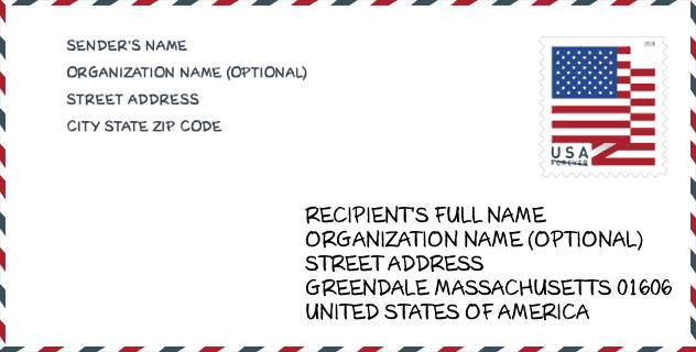
Envelope Example

This is an example of a US zip envelope. You can use a 5-digit zipcode or a detailed 9-digit zipcode to copy the mail in the following address format.
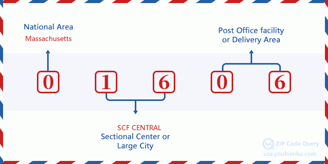
01606 Basic Meaning
What does each digit of ZIP Code 01606 stands for? The first digit designates a national area, which ranges from zero for the Northeast to nine for the far West. The 2-3 digits are the code of a sectional center facility in that region. The last two digits designate small post offices or postal zones.
Online Map

This is online map of the address Worcester, Massachusetts, United States. You may use button to move and zoom in / out. The map information is for reference only.
University

This is the ZIP Code 01606 - University page list. Its detail university Name, Street, City, State, ZIP Code, Phone is as below.
| Name | Street | City | State | ZIP Code | Phone |
| Porter and Chester Institute of Worcester | 220 Brooks Street | Worcester | MA | 01606 | (508) 366-0296 |
Library

This is the ZIP Code 01606 - Library page list. Its detail Library Name, Address, City, State, ZIP Code, Phone is as below.
- Name: FRANCES PERKINS BRANCH LIBRARY AT GREENDALE
- Address: 470 WEST BOYLSTON STREET
- City: WORCESTER
- State: MA - Massachusetts
- ZIP Code: 01606
- Phone: (508) 799-1687
School
This is the ZIP Code 01606 - School page list. Its detail School Name, Address, City, State, ZIP Code is as below.
| School Name | Address | City | State | Grades | ZIP Code |
|---|---|---|---|---|---|
| Abby Kelley Foster Charter Public School | 10 New Bond Street | Worcester | MA | UG | 01606 |
| Burncoat Senior High | 179 Burncoat Street | Worcester | MA | UG | 01606 |
| Burncoat Street | 526 Burncoat Street | Worcester | MA | UG | 01606 |
| Burncoat Middle School | 135 Burncoat Street | Worcester | MA | UG | 01606 |
| Clark St Community | 280 Clark Street | Worcester | MA | UG | 01606 |
| Norrback Avenue | 44 Malden Street | Worcester | MA | UG | 01606 |
| Worcester Arts Magnet School | 315 St Nicholas Avenue | Worcester | MA | UG | 01606 |
| Thorndyke Road | 30 Thorndyke Rd | Worcester | MA | UG | 01606 |
Population for ZIP Code 01606

What is the total population in ZIP Code 01606? Below is detail information.
- Population for ZIP Code 01606: 20,146
- 2010 Population: 19,077
The 2020 demographic statistics are in progress. The current population in ZIP code 01606 is 20,146, and the population in 2010 is 19,077.
Gender

In all the statistical population, the male population is 9,156, the female population is 9,921.
- Male Population: 9,156
- Female Population: 9,921
Race

In all the statistical population, the male population is 9,156, the female population is 9,921.
- White Population: 16,174
- Black Population: 1,829
- Hispanic Population: 1,502
- Asian Population: 827
- Hawaiian Population: 17
- Indian Population: 145
- Other Population: 671
Age

In all the statistical population, the White population is 16,174, the Black population is 1,829, the Hispanic population is 1,502, the Asian population is 827, the Hawaiian population is 17, the Indian Ppopulation is 145 and Other population is 671.
- Age's Median: 38.9
- Median of male age: 37.5
- Median of female age: 40.4
Households for ZIP Code 01606
ZIP code 01606 has 7,943 households, with an average number of 2.35 persons per household. The average income per household in Zip code 01606 is 66,130 USD, and the average house value is 225,400 USD.
- Households Per Zipcode: 7,943
- Persons Per Household: 2.35
- Average House Value: 225,400
- Income Per Household: 66,130
Geographic

The latitude of the Zip code 01606 is 42.313314, the longitude is -71.796346, and the elevation is 593. It has land area of 5.928 square miles, and water area of 0.009 square miles. The time zone for ZIP code 01606 is Eastern (GMT -05:00). Daylight saving time should be observed in the area where the zip code is located.
- Latitude: 42.313314
- Longitude: -71.796346
- Elevation: 593
- Land Area: 5.928
- Water Area: 0.009
- Time Zone: Eastern (GMT -05:00)
- Region: Northeast
- Division: New England
- Day Light Saving: Y
Congressional District

The Congressional District for ZIP code 01606 is Massachusetts's 2nd congressional district, the Congressional Land Area is 1628 square mile.
- Congressional District: 2nd
- Congressional Land Area: 1628
Delivery

In the ZIP code 01606, there are 8,573 residential delivery mailboxes and centralized units, and 539 commercial delivery mailbox and centralized units, 7,108 single family deliveries and 1,016 multifamily deliveries, and the box count is 10,980. The main post office has city delivery carrier routes for the ZIP code 01606.
- Delivery Residential: 8,573
- Delivery Business: 539
- Delivery Total: 10,980
- Single Family Delivery Units: 7,108
- Multi Family Delivery Units: 1,016
- City Delivery Indicator: Y
Business

In ZIP code 01606, the number of business is 438, the number of employee is 8,927, the business first quarter payroll is 100,960,000 USD, the business annual payroll is 405,077,000 USD.
- Number Of Businesses: 438
- Number Of Employees: 8,927
- Business First Quarter Payroll: 100,960,000
- Business Annual Payroll: 405,077,000


Add new comment