ZIP Code: 01609, Worcester, MA
ZIP Code 01609 is located in Worcester, Massachusetts. Its detail State, County, City, Longitude, Latitude, Envelope Example, Population is as below.
ZIP Code 01609 Information

-
-
Country:
U.S. - United States
State:
County FIPS:
25027
City:
City Type ?In many cases, a ZIP Code can have multiple "names", meaning cities, towns, or subdivisions, in its boundaries. However, it will ALWAYS have exactly 1 "default" name. D - Default - This is the "preferred" name - by the USPS - for a city. Each ZIP Code has one - and only one - "default" name. In most cases, this is what people who live in that area call the city as well. A - Acceptable - This name can be used for mailing purposes. Often times alternative names are large neighborhoods or sections of the city/town. In some cases a ZIP Code may have several "acceptable" names which is used to group towns under one ZIP Code. N - Not Acceptable - A "not acceptable" name is, in many cases, a nickname that residents give that location. According to the USPS, you should NOT send mail to that ZIP Code using the "not acceptable" name when mailing.:
D (Default)
ZIP Code:
01609
❓What does D (Default) mean? This is the "preferred" name - by the USPS - for a city. Each ZIP Code has one - and only one - "default" name. In most cases, this is what people who live in that area call the city as well.
ZIP Code 01609 Plus 4
ZIP Code 5 plus 4 is the extension of 5-digit zip code, It can be used to locate a more detailed location. The last four digits designate segment or one side of a street or an apartment. You can find the ZIP+4 code and corresponding address of the zip code 01609 below.
| ZIP Code 5 Plus 4 | Address |
|---|---|
| 01609-1000 | 185 MORELAND ST, WORCESTER, MA |
| 01609-1001 | 1 BEL AIR ST, WORCESTER, MA |
| 01609-1002 | 0 BEL AIR ST, WORCESTER, MA |
| 01609-1002 | 2 BEL AIR ST, WORCESTER, MA |
| 01609-1003 | 1 BREWER ST, WORCESTER, MA |
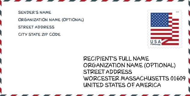
Envelope Example

This is an example of a US zip envelope. You can use a 5-digit zipcode or a detailed 9-digit zipcode to copy the mail in the following address format.
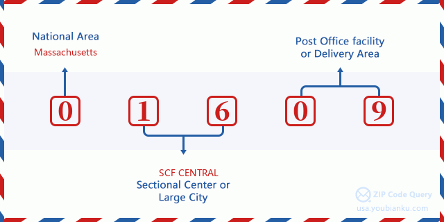
01609 Basic Meaning
What does each digit of ZIP Code 01609 stands for? The first digit designates a national area, which ranges from zero for the Northeast to nine for the far West. The 2-3 digits are the code of a sectional center facility in that region. The last two digits designate small post offices or postal zones.
Online Map

This is online map of the address Worcester, Massachusetts, United States. You may use button to move and zoom in / out. The map information is for reference only.
University

This is the ZIP Code 01609 - University page list. Its detail university Name, Street, City, State, ZIP Code, Phone is as below.
| Name | Street | City | State | ZIP Code | Phone |
| Rob Roy Academy-Worcester | 150 Pleasant St | Worcester | MA | 01609 | (508) 799-2111 |
Museum

This is the ZIP Code 01609 - Museum page list. Its detail Museum Name, Street, City, State, ZIP Code, Phone is as below.
| Name | Street | City | State | ZIP Code | Phone |
| JACOB KNIGHT MEMORIAL ART GALLERY | 61 SEVER ST | WORCESTER | MA | 01609 | (508) 373-9529 |
| NEW ART GALLERY | 100 INSTITUTE ROAD | WORCESTER | MA | 01609 |
School
This is the ZIP Code 01609 - School page list. Its detail School Name, Address, City, State, ZIP Code is as below.
| School Name | Address | City | State | Grades | ZIP Code |
|---|---|---|---|---|---|
| Chandler Elementary Community | 114 Chandler Street | Worcester | MA | UG | 01609 |
| Elm Park Community | 23 North Ashland Street | Worcester | MA | UG | 01609 |
Population for ZIP Code 01609

What is the total population in ZIP Code 01609? Below is detail information.
- Population for ZIP Code 01609: 17,725
- 2010 Population: 22,421
The 2020 demographic statistics are in progress. The current population in ZIP code 01609 is 17,725, and the population in 2010 is 22,421.
Gender

In all the statistical population, the male population is 11,664, the female population is 10,757.
- Male Population: 11,664
- Female Population: 10,757
Race

In all the statistical population, the male population is 11,664, the female population is 10,757.
- White Population: 17,019
- Black Population: 2,261
- Hispanic Population: 4,083
- Asian Population: 1,549
- Hawaiian Population: 39
- Indian Population: 233
- Other Population: 2,044
Age

In all the statistical population, the White population is 17,019, the Black population is 2,261, the Hispanic population is 4,083, the Asian population is 1,549, the Hawaiian population is 39, the Indian Ppopulation is 233 and Other population is 2,044.
- Age's Median: 27.6
- Median of male age: 25.8
- Median of female age: 30.1
Households for ZIP Code 01609
ZIP code 01609 has 7,651 households, with an average number of 2.34 persons per household. The average income per household in Zip code 01609 is 44,943 USD, and the average house value is 313,200 USD.
- Households Per Zipcode: 7,651
- Persons Per Household: 2.34
- Average House Value: 313,200
- Income Per Household: 44,943
Geographic

The latitude of the Zip code 01609 is 42.287550, the longitude is -71.830670, and the elevation is 584. It has land area of 3.821 square miles, and water area of 0.022 square miles. The time zone for ZIP code 01609 is Eastern (GMT -05:00). Daylight saving time should be observed in the area where the zip code is located.
- Latitude: 42.287550
- Longitude: -71.830670
- Elevation: 584
- Land Area: 3.821
- Water Area: 0.022
- Time Zone: Eastern (GMT -05:00)
- Region: Northeast
- Division: New England
- Day Light Saving: Y
Congressional District

The Congressional District for ZIP code 01609 is Massachusetts's 2nd congressional district, the Congressional Land Area is 1628 square mile.
- Congressional District: 2nd
- Congressional Land Area: 1628
Delivery

In the ZIP code 01609, there are 7,575 residential delivery mailboxes and centralized units, and 705 commercial delivery mailbox and centralized units, 4,192 single family deliveries and 2,864 multifamily deliveries, and the box count is 8,590. The main post office has city delivery carrier routes for the ZIP code 01609.
- Delivery Residential: 7,575
- Delivery Business: 705
- Delivery Total: 8,590
- Single Family Delivery Units: 4,192
- Multi Family Delivery Units: 2,864
- City Delivery Indicator: Y
Business

In ZIP code 01609, the number of business is 543, the number of employee is 10,986, the business first quarter payroll is 99,831,000 USD, the business annual payroll is 416,989,000 USD.
- Number Of Businesses: 543
- Number Of Employees: 10,986
- Business First Quarter Payroll: 99,831,000
- Business Annual Payroll: 416,989,000


Add new comment