ZIP Code: 01830, Haverhill, MA
ZIP Code 01830 is located in Haverhill, Massachusetts. Its detail State, County, City, Longitude, Latitude, Envelope Example, Population is as below.
ZIP Code 01830 Information

-
-
Country:
U.S. - United States
State:
County FIPS:
25009
County:
City:
City Type ?In many cases, a ZIP Code can have multiple "names", meaning cities, towns, or subdivisions, in its boundaries. However, it will ALWAYS have exactly 1 "default" name. D - Default - This is the "preferred" name - by the USPS - for a city. Each ZIP Code has one - and only one - "default" name. In most cases, this is what people who live in that area call the city as well. A - Acceptable - This name can be used for mailing purposes. Often times alternative names are large neighborhoods or sections of the city/town. In some cases a ZIP Code may have several "acceptable" names which is used to group towns under one ZIP Code. N - Not Acceptable - A "not acceptable" name is, in many cases, a nickname that residents give that location. According to the USPS, you should NOT send mail to that ZIP Code using the "not acceptable" name when mailing.:
D (Default)
ZIP Code:
01830
❓What does D (Default) mean? This is the "preferred" name - by the USPS - for a city. Each ZIP Code has one - and only one - "default" name. In most cases, this is what people who live in that area call the city as well.
ZIP Code 01830 Plus 4
ZIP Code 5 plus 4 is the extension of 5-digit zip code, It can be used to locate a more detailed location. The last four digits designate segment or one side of a street or an apartment. You can find the ZIP+4 code and corresponding address of the zip code 01830 below.
| ZIP Code 5 Plus 4 | Address |
|---|---|
| 01830-1300 | 1 PEPPERCORN LN, HAVERHILL, MA |
| 01830-1301 | 1 MERRILL AVE, HAVERHILL, MA |
| 01830-1302 | 2 MERRILL AVE, HAVERHILL, MA |
| 01830-1303 | 1 ROSEDALE AVE, HAVERHILL, MA |
| 01830-1304 | 2 ROSEDALE AVE, HAVERHILL, MA |
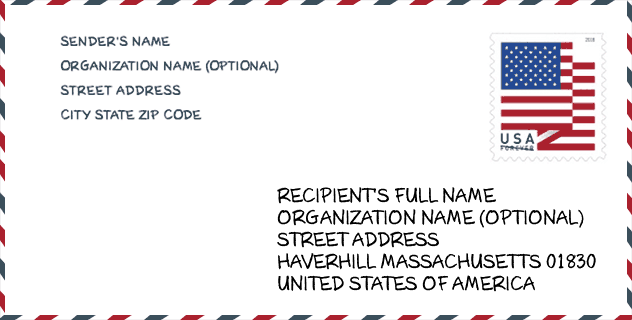
Envelope Example

This is an example of a US zip envelope. You can use a 5-digit zipcode or a detailed 9-digit zipcode to copy the mail in the following address format.
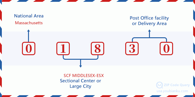
01830 Basic Meaning
What does each digit of ZIP Code 01830 stands for? The first digit designates a national area, which ranges from zero for the Northeast to nine for the far West. The 2-3 digits are the code of a sectional center facility in that region. The last two digits designate small post offices or postal zones.
Online Map

This is online map of the address Haverhill, Massachusetts, United States. You may use button to move and zoom in / out. The map information is for reference only.
Hospital

This is the ZIP Code 01830 - Hospital page list. Its detail Hospital Name, Street, City, State, ZIP Code, Phone is as below.
- Name: WHITTIER PAVILION
- Address: HAVERHILL
- City: 76 SUMMER STREET
- State: MA
- ZIP Code: 01830
- Phone: (978) 373-8222
Library

This is the ZIP Code 01830 - Library page list. Its detail Library Name, Address, City, State, ZIP Code, Phone is as below.
- Name: HAVERHILL PUBLIC LIBRARY
- Address: 99 MAIN ST.
- City: HAVERHILL
- State: MA - Massachusetts
- ZIP Code: 01830
- Phone: (978) 373-1586
School

This is the ZIP Code 01830 - School page list. Its detail School Name, Address, City, State, ZIP Code is as below.
| School Name | Address | City | State | Grades | ZIP Code |
|---|---|---|---|---|---|
| Golden Hill | 140 Boardman Street | Haverhill | MA | UG | 01830 |
| Dr Paul Nettle | 150 Boardman Street | Haverhill | MA | UG | 01830 |
| John G Whittier | 256 Concord Street | Haverhill | MA | UG | 01830 |
| Walnut Square | 645 Main Street | Haverhill | MA | UG | 01830 |
| Pentucket Lake Elementary | 252 Concord Street | Haverhill | MA | UG | 01830 |
| TEACH | 551 Washington Street | Haverhill | MA | UG | 01830 |
| Tilton Upper Middle School | 415 Primrose Street | Haverhill | MA | UG | 01830 |
| Crowell | 26 Belmont Avenue | Haverhill | MA | UG | 01830 |
| Moody Preschool Extension | 514 Main Street | Haverhill | MA | UG | 01830 |
| Whittier Regional Vocational | 115 Amesbury Line Rd | Haverhill | MA | UG | 01830 |
Population for ZIP Code 01830

What is the total population in ZIP Code 01830? Below is detail information.
- Population for ZIP Code 01830: 25,507
- 2010 Population: 25,137
The 2020 demographic statistics are in progress. The current population in ZIP code 01830 is 25,507, and the population in 2010 is 25,137.
Gender

In all the statistical population, the male population is 12,106, the female population is 13,031.
- Male Population: 12,106
- Female Population: 13,031
Race

In all the statistical population, the male population is 12,106, the female population is 13,031.
- White Population: 22,276
- Black Population: 1,090
- Hispanic Population: 3,824
- Asian Population: 480
- Hawaiian Population: 35
- Indian Population: 235
- Other Population: 1,714
Age

In all the statistical population, the White population is 22,276, the Black population is 1,090, the Hispanic population is 3,824, the Asian population is 480, the Hawaiian population is 35, the Indian Ppopulation is 235 and Other population is 1,714.
- Age's Median: 40.0
- Median of male age: 38.3
- Median of female age: 41.5
Households for ZIP Code 01830
ZIP code 01830 has 10,068 households, with an average number of 2.40 persons per household. The average income per household in Zip code 01830 is 62,194 USD, and the average house value is 294,900 USD.
- Households Per Zipcode: 10,068
- Persons Per Household: 2.40
- Average House Value: 294,900
- Income Per Household: 62,194
Geographic

The latitude of the Zip code 01830 is 42.795190, the longitude is -71.055630, and the elevation is 169. It has land area of 13.824 square miles, and water area of 1.292 square miles. The time zone for ZIP code 01830 is Eastern (GMT -05:00). Daylight saving time should be observed in the area where the zip code is located.
- Latitude: 42.795190
- Longitude: -71.055630
- Elevation: 169
- Land Area: 13.824
- Water Area: 1.292
- Time Zone: Eastern (GMT -05:00)
- Region: Northeast
- Division: New England
- Day Light Saving: Y
Congressional District

The Congressional District for ZIP code 01830 is Massachusetts's 1st|3rd|06th congressional district, the Congressional Land Area is 2350.29|757.86|526.79 square mile.
- Congressional District: 1st|3rd|06th
- Congressional Land Area: 2350.29|757.86|526.79
Delivery

In the ZIP code 01830, there are 10,628 residential delivery mailboxes and centralized units, and 695 commercial delivery mailbox and centralized units, 7,683 single family deliveries and 2,272 multifamily deliveries, and the box count is 11,321. The main post office has city delivery carrier routes for the ZIP code 01830.
- Delivery Residential: 10,628
- Delivery Business: 695
- Delivery Total: 11,321
- Single Family Delivery Units: 7,683
- Multi Family Delivery Units: 2,272
- City Delivery Indicator: Y
Business

In ZIP code 01830, the number of business is 501, the number of employee is 7,006, the business first quarter payroll is 62,725,000 USD, the business annual payroll is 272,014,000 USD.
- Number Of Businesses: 501
- Number Of Employees: 7,006
- Business First Quarter Payroll: 62,725,000
- Business Annual Payroll: 272,014,000


Add new comment