ZIP Code: 01880, Wakefield, MA
ZIP Code 01880 is located in Wakefield, Massachusetts. Its detail State, County, City, Longitude, Latitude, Envelope Example, Population is as below.

ZIP Code 01880 Information

-
-
Country:
U.S. - United States
State:
County FIPS:
25017
City:
Area Code:
City Type ?In many cases, a ZIP Code can have multiple "names", meaning cities, towns, or subdivisions, in its boundaries. However, it will ALWAYS have exactly 1 "default" name. D - Default - This is the "preferred" name - by the USPS - for a city. Each ZIP Code has one - and only one - "default" name. In most cases, this is what people who live in that area call the city as well. A - Acceptable - This name can be used for mailing purposes. Often times alternative names are large neighborhoods or sections of the city/town. In some cases a ZIP Code may have several "acceptable" names which is used to group towns under one ZIP Code. N - Not Acceptable - A "not acceptable" name is, in many cases, a nickname that residents give that location. According to the USPS, you should NOT send mail to that ZIP Code using the "not acceptable" name when mailing.:
D (Default)
ZIP Code:
01880
❓What does D (Default) mean? This is the "preferred" name - by the USPS - for a city. Each ZIP Code has one - and only one - "default" name. In most cases, this is what people who live in that area call the city as well.
ZIP Code 01880 Plus 4
ZIP Code 5 plus 4 is the extension of 5-digit zip code, It can be used to locate a more detailed location. The last four digits designate segment or one side of a street or an apartment. You can find the ZIP+4 code and corresponding address of the zip code 01880 below.
| ZIP Code 5 Plus 4 | Address |
|---|---|
| 01880-0001 | PO BOX 1, WAKEFIELD, MA |
| 01880-0030 | PO BOX 30, WAKEFIELD, MA |
| 01880-0031 | PO BOX 31, WAKEFIELD, MA |
| 01880-0033 | PO BOX 870, WAKEFIELD, MA |
| 01880-0040 | PO BOX 40, WAKEFIELD, MA |
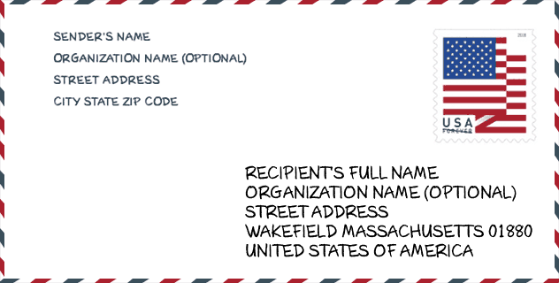
Envelope Example

This is an example of a US zip envelope. You can use a 5-digit zipcode or a detailed 9-digit zipcode to copy the mail in the following address format.
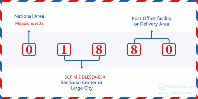
01880 Basic Meaning
What does each digit of ZIP Code 01880 stands for? The first digit designates a national area, which ranges from zero for the Northeast to nine for the far West. The 2-3 digits are the code of a sectional center facility in that region. The last two digits designate small post offices or postal zones.
Online Map

This is online map of the address Wakefield, Massachusetts, United States. You may use button to move and zoom in / out. The map information is for reference only.
Museum

This is the ZIP Code 01880 - Museum page list. Its detail Museum Name, Street, City, State, ZIP Code, Phone is as below.
- Name: PLEASURE ISLAND
- Street: 376 WATER STR
- City: WAKEFIELD
- State: MA
- ZIP Code: 01880
- Phone: (781) 246-0653
Library

This is the ZIP Code 01880 - Library page list. Its detail Library Name, Address, City, State, ZIP Code, Phone is as below.
| Name | Address | City | State | ZIP Code | Phone |
|---|---|---|---|---|---|
| LUCIUS BEEBE MEMORIAL LIBRARY | 345 MAIN STREET | WAKEFIELD | MA | 01880 | (781) 246-6335 |
| LUCIUS BEEBE MEMORIAL LIBRARY | 345 MAIN STREET | WAKEFIELD | MA | 01880 | (781) 246-6334 |
School

This is the ZIP Code 01880 - School page list. Its detail School Name, Address, City, State, ZIP Code is as below.
| School Name | Address | City | State | Grades | ZIP Code |
|---|---|---|---|---|---|
| Northeast Metro Regional Vocational | 100 Hemlock Rd | Wakefield | MA | UG | 01880 |
| Galvin Middle School | 525 Main Street | Wakefield | MA | UG | 01880 |
| Dolbeare | 340 Lowell Street | Wakefield | MA | UG | 01880 |
| Woodville School | 30 Farm Street | Wakefield | MA | UG | 01880 |
| Greenwood | 1030 Main Street | Wakefield | MA | UG | 01880 |
| Walton | 18 Davidson Road | Wakefield | MA | UG | 01880 |
| Wakefield Memorial High | 60 Farm Street | Wakefield | MA | UG | 01880 |
| Early Childhood Center at the Doyle School | 11 Paul Avenue | Wakefield | MA | UG | 01880 |
Population for ZIP Code 01880

What is the total population in ZIP Code 01880? Below is detail information.
- Population for ZIP Code 01880: 27,034
- 2010 Population: 24,733
The 2020 demographic statistics are in progress. The current population in ZIP code 01880 is 27,034, and the population in 2010 is 24,733.
Gender

In all the statistical population, the male population is 11,904, the female population is 12,829.
- Male Population: 11,904
- Female Population: 12,829
Race

In all the statistical population, the male population is 11,904, the female population is 12,829.
- White Population: 23,699
- Black Population: 316
- Hispanic Population: 561
- Asian Population: 736
- Hawaiian Population: 8
- Indian Population: 90
- Other Population: 181
Age

In all the statistical population, the White population is 23,699, the Black population is 316, the Hispanic population is 561, the Asian population is 736, the Hawaiian population is 8, the Indian Ppopulation is 90 and Other population is 181.
- Age's Median: 41.9
- Median of male age: 40.6
- Median of female age: 43.0
Households for ZIP Code 01880
ZIP code 01880 has 9,874 households, with an average number of 2.48 persons per household. The average income per household in Zip code 01880 is 95,954 USD, and the average house value is 470,900 USD.
- Households Per Zipcode: 9,874
- Persons Per Household: 2.48
- Average House Value: 470,900
- Income Per Household: 95,954
Geographic

The latitude of the Zip code 01880 is 42.501286, the longitude is -71.066727, and the elevation is 82. It has land area of 6.912 square miles, and water area of 0.539 square miles. The time zone for ZIP code 01880 is Eastern (GMT -05:00). Daylight saving time should be observed in the area where the zip code is located.
- Latitude: 42.501286
- Longitude: -71.066727
- Elevation: 82
- Land Area: 6.912
- Water Area: 0.539
- Time Zone: Eastern (GMT -05:00)
- Region: Northeast
- Division: New England
- Day Light Saving: Y
Congressional District

The Congressional District for ZIP code 01880 is Massachusetts's 06th congressional district, the Congressional Land Area is 526.79 square mile.
- Congressional District: 06th
- Congressional Land Area: 526.79
Delivery

In the ZIP code 01880, there are 10,901 residential delivery mailboxes and centralized units, and 1,063 commercial delivery mailbox and centralized units, 8,673 single family deliveries and 2,037 multifamily deliveries, and the box count is 13,023. The main post office has city delivery carrier routes for the ZIP code 01880.
- Delivery Residential: 10,901
- Delivery Business: 1,063
- Delivery Total: 13,023
- Single Family Delivery Units: 8,673
- Multi Family Delivery Units: 2,037
- City Delivery Indicator: Y
Business

In ZIP code 01880, the number of business is 908, the number of employee is 13,849, the business first quarter payroll is 260,344,000 USD, the business annual payroll is 955,323,000 USD.
- Number Of Businesses: 908
- Number Of Employees: 13,849
- Business First Quarter Payroll: 260,344,000
- Business Annual Payroll: 955,323,000


Add new comment