ZIP Code: 01887, Wilmington, MA
ZIP Code 01887 is located in Wilmington, Massachusetts. Its detail State, County, City, Longitude, Latitude, Envelope Example, Population is as below.

ZIP Code 01887 Information

-
-
Country:
U.S. - United States
State:
County FIPS:
25017
City:
Area Code:
City Type ?In many cases, a ZIP Code can have multiple "names", meaning cities, towns, or subdivisions, in its boundaries. However, it will ALWAYS have exactly 1 "default" name. D - Default - This is the "preferred" name - by the USPS - for a city. Each ZIP Code has one - and only one - "default" name. In most cases, this is what people who live in that area call the city as well. A - Acceptable - This name can be used for mailing purposes. Often times alternative names are large neighborhoods or sections of the city/town. In some cases a ZIP Code may have several "acceptable" names which is used to group towns under one ZIP Code. N - Not Acceptable - A "not acceptable" name is, in many cases, a nickname that residents give that location. According to the USPS, you should NOT send mail to that ZIP Code using the "not acceptable" name when mailing.:
D (Default)
ZIP Code:
01887
❓What does D (Default) mean? This is the "preferred" name - by the USPS - for a city. Each ZIP Code has one - and only one - "default" name. In most cases, this is what people who live in that area call the city as well.
ZIP Code 01887 Plus 4
ZIP Code 5 plus 4 is the extension of 5-digit zip code, It can be used to locate a more detailed location. The last four digits designate segment or one side of a street or an apartment. You can find the ZIP+4 code and corresponding address of the zip code 01887 below.
| ZIP Code 5 Plus 4 | Address |
|---|---|
| 01887-0001 | PO BOX 1, WILMINGTON, MA |
| 01887-0121 | PO BOX 121, WILMINGTON, MA |
| 01887-0241 | PO BOX 241, WILMINGTON, MA |
| 01887-0361 | PO BOX 361, WILMINGTON, MA |
| 01887-0461 | PO BOX 461, WILMINGTON, MA |
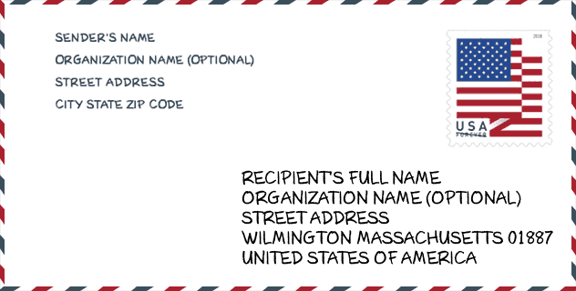
Envelope Example

This is an example of a US zip envelope. You can use a 5-digit zipcode or a detailed 9-digit zipcode to copy the mail in the following address format.
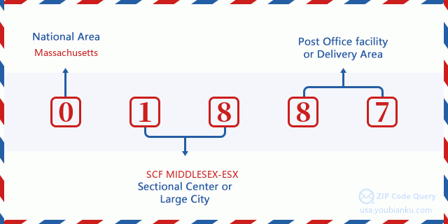
01887 Basic Meaning
What does each digit of ZIP Code 01887 stands for? The first digit designates a national area, which ranges from zero for the Northeast to nine for the far West. The 2-3 digits are the code of a sectional center facility in that region. The last two digits designate small post offices or postal zones.
Online Map

This is online map of the address Wilmington, Massachusetts, United States. You may use button to move and zoom in / out. The map information is for reference only.
University

This is the ZIP Code 01887 - University page list. Its detail university Name, Street, City, State, ZIP Code, Phone is as below.
| Name | Street | City | State | ZIP Code | Phone |
| ITT Technical Institute-Wilmington | 200 Ballardvale Street, Building 1, Suite 200 | Wilmington | MA | 01887 | - |
Museum

This is the ZIP Code 01887 - Museum page list. Its detail Museum Name, Street, City, State, ZIP Code, Phone is as below.
- Name: WILMINGTON TOWN MUSEUM
- Street: 430 SALEM STREET
- City: WILMINGTON
- State: MA
- ZIP Code: 01887
- Phone: (978) 658-5475
Library

This is the ZIP Code 01887 - Library page list. Its detail Library Name, Address, City, State, ZIP Code, Phone is as below.
- Name: WILMINGTON MEMORIAL LIBRARY
- Address: 175 MIDDLESEX AVE.
- City: WILMINGTON
- State: MA - Massachusetts
- ZIP Code: 01887
- Phone: (978) 658-2967
School
This is the ZIP Code 01887 - School page list. Its detail School Name, Address, City, State, ZIP Code is as below.
| School Name | Address | City | State | Grades | ZIP Code |
|---|---|---|---|---|---|
| Boutwell | 17 Boutwell Avenue | Wilmington | MA | UG | 01887 |
| North Intermediate | 320 Salem Street | Wilmington | MA | UG | 01887 |
| West Intermediate | 22 Carter Lane | Wilmington | MA | UG | 01887 |
| Wilmington Middle School | 25 Carter Lane | Wilmington | MA | UG | 01887 |
| Shawsheen Elementary | 298 Shawsheen Avenue | Wilmington | MA | UG | 01887 |
| Wildwood | 182 Wildwood Street | Wilmington | MA | UG | 01887 |
| Wilmington High | 159 Church Street | Wilmington | MA | UG | 01887 |
| Woburn Street | 227 Woburn Street | Wilmington | MA | UG | 01887 |
Population for ZIP Code 01887

What is the total population in ZIP Code 01887? Below is detail information.
- Population for ZIP Code 01887: 23,832
- 2010 Population: 22,325
The 2020 demographic statistics are in progress. The current population in ZIP code 01887 is 23,832, and the population in 2010 is 22,325.
Gender

In all the statistical population, the male population is 10,949, the female population is 11,376.
- Male Population: 10,949
- Female Population: 11,376
Race

In all the statistical population, the male population is 10,949, the female population is 11,376.
- White Population: 21,151
- Black Population: 268
- Hispanic Population: 403
- Asian Population: 971
- Hawaiian Population: 22
- Indian Population: 71
- Other Population: 169
Age

In all the statistical population, the White population is 21,151, the Black population is 268, the Hispanic population is 403, the Asian population is 971, the Hawaiian population is 22, the Indian Ppopulation is 71 and Other population is 169.
- Age's Median: 41.1
- Median of male age: 40.2
- Median of female age: 41.9
Households for ZIP Code 01887
ZIP code 01887 has 7,532 households, with an average number of 2.93 persons per household. The average income per household in Zip code 01887 is 122,813 USD, and the average house value is 447,300 USD.
- Households Per Zipcode: 7,532
- Persons Per Household: 2.93
- Average House Value: 447,300
- Income Per Household: 122,813
Geographic

The latitude of the Zip code 01887 is 42.565327, the longitude is -71.174652, and the elevation is 88. It has land area of 16.984 square miles, and water area of 0.172 square miles. The time zone for ZIP code 01887 is Eastern (GMT -05:00). Daylight saving time should be observed in the area where the zip code is located.
- Latitude: 42.565327
- Longitude: -71.174652
- Elevation: 88
- Land Area: 16.984
- Water Area: 0.172
- Time Zone: Eastern (GMT -05:00)
- Region: Northeast
- Division: New England
- Day Light Saving: Y
Congressional District

The Congressional District for ZIP code 01887 is Massachusetts's 06th congressional district, the Congressional Land Area is 526.79 square mile.
- Congressional District: 06th
- Congressional Land Area: 526.79
Delivery

In the ZIP code 01887, there are 8,134 residential delivery mailboxes and centralized units, and 857 commercial delivery mailbox and centralized units, 7,121 single family deliveries and 704 multifamily deliveries, and the box count is 10,491. The main post office has city delivery carrier routes for the ZIP code 01887.
- Delivery Residential: 8,134
- Delivery Business: 857
- Delivery Total: 10,491
- Single Family Delivery Units: 7,121
- Multi Family Delivery Units: 704
- City Delivery Indicator: Y
Business

In ZIP code 01887, the number of business is 869, the number of employee is 21,870, the business first quarter payroll is 494,979,000 USD, the business annual payroll is 1,807,582,000 USD.
- Number Of Businesses: 869
- Number Of Employees: 21,870
- Business First Quarter Payroll: 494,979,000
- Business Annual Payroll: 1,807,582,000


Add new comment