United States ZIP Code: 01960
This is the Massachusetts ZIP Code 01960 page list. Its detail State, County, City, Longitude, Latitude, Envelope Example, Population is as below.
ZIP Code 01960 Information

-
-
Country:
U.S. - United States
State:
State FIPS:
25
ZIP Code:
01960
ZIP Type:
S (Standard)
❓What does S (Standard) mean? A "standard" ZIP Code is what most people think of when they talk about ZIP Codes - essentially a town, city, or a division of a city that has mail service.
ZIP Code 01960 - City

This is the city information corresponding to 01960:
| State | County | City | City Type ?In many cases, a ZIP Code can have multiple "names", meaning cities, towns, or subdivisions, in its boundaries. However, it will ALWAYS have exactly 1 "default" name. D - Default - This is the "preferred" name - by the USPS - for a city. Each ZIP Code has one - and only one - "default" name. In most cases, this is what people who live in that area call the city as well. A - Acceptable - This name can be used for mailing purposes. Often times alternative names are large neighborhoods or sections of the city/town. In some cases a ZIP Code may have several "acceptable" names which is used to group towns under one ZIP Code. N - Not Acceptable - A "not acceptable" name is, in many cases, a nickname that residents give that location. According to the USPS, you should NOT send mail to that ZIP Code using the "not acceptable" name when mailing. | ZIP Code |
|---|---|---|---|---|
| MA | Essex | Peabody | D (Default) | 01960 |
| MA | Essex | West Peabody | N (Not Acceptable) | 01960 |
❓What does D (Default) mean? This is the "preferred" name - by the USPS - for a city. Each ZIP Code has one - and only one - "default" name. In most cases, this is what people who live in that area call the city as well.
❓What does N (Not Acceptable) mean? A "not acceptable" name is, in many cases, a nickname that residents give that location. According to the USPS, you should NOT send mail to that ZIP Code using the "not acceptable" name when mailing.
ZIP Code 01960 Plus 4
ZIP Code 5 plus 4 is the extension of 5-digit zip code, It can be used to locate a more detailed location. The last four digits designate segment or one side of a street or an apartment. You can find the ZIP+4 code and corresponding address of the zip code 01960 below.
| ZIP Code 5 Plus 4 | Address |
|---|---|
| 01960-0801 | PO BOX 1, PEABODY, MA |
| 01960-0961 | PO BOX 161, PEABODY, MA |
| 01960-1001 | 1 BLACKSTONE ST, PEABODY, MA |
| 01960-1002 | 2 BLACKSTONE ST, PEABODY, MA |
| 01960-1003 | 1 GATES RD, PEABODY, MA |
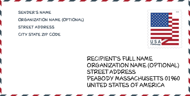
Envelope Example

This is an example of a US zip envelope. You can use a 5-digit zipcode or a detailed 9-digit zipcode to copy the mail in the following address format.
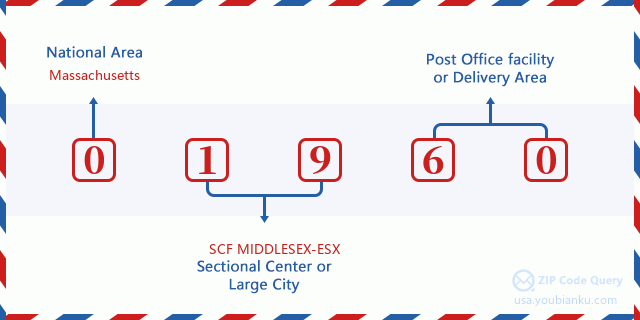
01960 Basic Meaning
What does each digit of ZIP Code 01960 stands for? The first digit designates a national area, which ranges from zero for the Northeast to nine for the far West. The 2-3 digits are the code of a sectional center facility in that region. The last two digits designate small post offices or postal zones.
Online Map

This is online map of the address West Peabody, Massachusetts, United States. You may use button to move and zoom in / out. The map information is for reference only.
Museum

This is the ZIP Code 01960 - Museum page list. Its detail Museum Name, Street, City, State, ZIP Code, Phone is as below.
- Name: GEORGE PEABODY HOUSE MUSEUM
- Street: 24 LOWELL STREET
- City: PEABODY
- State: MA
- ZIP Code: 01960
- Phone: (978) 531-0355
Library

This is the ZIP Code 01960 - Library page list. Its detail Library Name, Address, City, State, ZIP Code, Phone is as below.
| Name | Address | City | State | ZIP Code | Phone |
|---|---|---|---|---|---|
| SOUTH BRANCH LIBRARY | 78 LYNN STREET | PEABODY | MA | 01960 | (508) 531-3380 |
| WEST BRANCH LIBRARY | 603 LOWELL STREET | PEABODY | MA | 01960 | (508) 535-3354 |
School

This is the ZIP Code 01960 - School page list. Its detail School Name, Address, City, State, ZIP Code is as below.
| School Name | Address | City | State | Grades | ZIP Code |
|---|---|---|---|---|---|
| Center | 18 Irving Street | Peabody | MA | UG | 01960 |
| J Henry Higgins Middle | 85 Perkins Street | Peabody | MA | UG | 01960 |
| John E Burke | 127 Birch Street | Peabody | MA | UG | 01960 |
| Captain Samuel Brown | 150 Lynn Street | Peabody | MA | UG | 01960 |
| South Memorial | 16 Maple St Ext | Peabody | MA | UG | 01960 |
| Thomas Carroll | 60 Northend Street | Peabody | MA | UG | 01960 |
| Peabody Veterans Memorial High | 485 Lowell Street | Peabody | MA | UG | 01960 |
| West Memorial | 15 Bow Street | Peabody | MA | UG | 01960 |
| William A Welch Sr | 50 Swampscott Avenue | Peabody | MA | UG | 01960 |
| John E. McCarthy | 76 Lake Street | Peabody | MA | UG | 01960 |
| Peabody Personalized Remote Education Program | 210 Andover Street | Peabody | MA | UG | 01960 |
Population for ZIP Code 01960

What is the total population in ZIP Code 01960? Below is detail information.
- Population for ZIP Code 01960: 52,553
- 2010 Population: 50,944
The 2020 demographic statistics are in progress. The current population in ZIP code 01960 is 52,553, and the population in 2010 is 50,944.
Gender

In all the statistical population, the male population is 24,200, the female population is 26,744.
- Male Population: 24,200
- Female Population: 26,744
Race

In all the statistical population, the male population is 24,200, the female population is 26,744.
- White Population: 46,760
- Black Population: 1,525
- Hispanic Population: 3,203
- Asian Population: 1,109
- Hawaiian Population: 54
- Indian Population: 199
- Other Population: 2,166
Age

In all the statistical population, the White population is 46,760, the Black population is 1,525, the Hispanic population is 3,203, the Asian population is 1,109, the Hawaiian population is 54, the Indian Ppopulation is 199 and Other population is 2,166.
- Age's Median: 44.5
- Median of male age: 42.4
- Median of female age: 46.4
Households for ZIP Code 01960
ZIP code 01960 has 21,128 households, with an average number of 2.39 persons per household. The average income per household in Zip code 01960 is 68,214 USD, and the average house value is 373,100 USD.
- Households Per Zipcode: 21,128
- Persons Per Household: 2.39
- Average House Value: 373,100
- Income Per Household: 68,214
Geographic

The latitude of the Zip code 01960 is 42.532576, the longitude is -70.973660, and the elevation is 161. It has land area of 16.01 square miles, and water area of 0.565 square miles. The time zone for ZIP code 01960 is Eastern (GMT -05:00). Daylight saving time should be observed in the area where the zip code is located.
- Latitude: 42.532576
- Longitude: -70.973660
- Elevation: 161
- Land Area: 16.01
- Water Area: 0.565
- Time Zone: Eastern (GMT -05:00)
- Region: Northeast
- Division: New England
- Day Light Saving: Y
Congressional District

The Congressional District for ZIP code 01960 is Massachusetts's 06th congressional district, the Congressional Land Area is 526.79 square mile.
- Congressional District: 06th
- Congressional Land Area: 526.79
Delivery

In the ZIP code 01960, there are 21,989 residential delivery mailboxes and centralized units, and 1,780 commercial delivery mailbox and centralized units, 14,997 single family deliveries and 5,379 multifamily deliveries, and the box count is 24,458. The main post office has city delivery carrier routes for the ZIP code 01960.
- Delivery Residential: 21,989
- Delivery Business: 1,780
- Delivery Total: 24,458
- Single Family Delivery Units: 14,997
- Multi Family Delivery Units: 5,379
- City Delivery Indicator: Y
Business

In ZIP code 01960, the number of business is 1,467, the number of employee is 22,936, the business first quarter payroll is 276,298,000 USD, the business annual payroll is 1,174,256,000 USD.
- Number Of Businesses: 1,467
- Number Of Employees: 22,936
- Business First Quarter Payroll: 276,298,000
- Business Annual Payroll: 1,174,256,000


Add new comment