United States ZIP Code: 02066
This is the Massachusetts ZIP Code 02066 page list. Its detail State, County, City, Longitude, Latitude, Envelope Example, Population is as below.

ZIP Code 02066 Information

-
-
Country:
U.S. - United States
State:
State FIPS:
25
ZIP Code:
02066
ZIP Type:
S (Standard)
❓What does S (Standard) mean? A "standard" ZIP Code is what most people think of when they talk about ZIP Codes - essentially a town, city, or a division of a city that has mail service.
ZIP Code 02066 - City

This is the city information corresponding to 02066:
| State | County | City | City Type ?In many cases, a ZIP Code can have multiple "names", meaning cities, towns, or subdivisions, in its boundaries. However, it will ALWAYS have exactly 1 "default" name. D - Default - This is the "preferred" name - by the USPS - for a city. Each ZIP Code has one - and only one - "default" name. In most cases, this is what people who live in that area call the city as well. A - Acceptable - This name can be used for mailing purposes. Often times alternative names are large neighborhoods or sections of the city/town. In some cases a ZIP Code may have several "acceptable" names which is used to group towns under one ZIP Code. N - Not Acceptable - A "not acceptable" name is, in many cases, a nickname that residents give that location. According to the USPS, you should NOT send mail to that ZIP Code using the "not acceptable" name when mailing. | ZIP Code |
|---|---|---|---|---|
| MA | Plymouth | Scituate | D (Default) | 02066 |
| MA | Plymouth | Scituate Center | N (Not Acceptable) | 02066 |
| MA | Plymouth | Scituate Harbor | N (Not Acceptable) | 02066 |
❓What does D (Default) mean? This is the "preferred" name - by the USPS - for a city. Each ZIP Code has one - and only one - "default" name. In most cases, this is what people who live in that area call the city as well.
❓What does N (Not Acceptable) mean? A "not acceptable" name is, in many cases, a nickname that residents give that location. According to the USPS, you should NOT send mail to that ZIP Code using the "not acceptable" name when mailing.
ZIP Code 02066 Plus 4
ZIP Code 5 plus 4 is the extension of 5-digit zip code, It can be used to locate a more detailed location. The last four digits designate segment or one side of a street or an apartment. You can find the ZIP+4 code and corresponding address of the zip code 02066 below.
| ZIP Code 5 Plus 4 | Address |
|---|---|
| 02066-0010 | PO BOX 10, SCITUATE, MA |
| 02066-0151 | PO BOX 151, SCITUATE, MA |
| 02066-0271 | PO BOX 271, SCITUATE, MA |
| 02066-0351 | PO BOX 351, SCITUATE, MA |
| 02066-0500 | PO BOX 500, SCITUATE, MA |
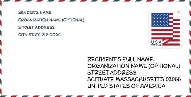
Envelope Example

This is an example of a US zip envelope. You can use a 5-digit zipcode or a detailed 9-digit zipcode to copy the mail in the following address format.
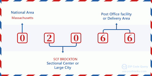
02066 Basic Meaning
What does each digit of ZIP Code 02066 stands for? The first digit designates a national area, which ranges from zero for the Northeast to nine for the far West. The 2-3 digits are the code of a sectional center facility in that region. The last two digits designate small post offices or postal zones.
Online Map

This is online map of the address Scituate Harbor, Massachusetts, United States. You may use button to move and zoom in / out. The map information is for reference only.
Museum

This is the ZIP Code 02066 - Museum page list. Its detail Museum Name, Street, City, State, ZIP Code, Phone is as below.
| Name | Street | City | State | ZIP Code | Phone |
| MARITIME MUSEUM | 301 DRIFTWAY | SCITUATE | MA | 02066 | (781) 545-5565 |
| PRESERVATION OF SCITUATES HERITAGE | TOWN HALL 600 CHIEF JUSTICE CUSHING | SCITUATE | MA | 02066 | |
| UNITARIAN HISTORICAL SOCIETY | 27 GROVE ST | SCITUATE | MA | 02066 | |
| STELLWAGEN BANK NATIONAL MARINE SANCTUARY | 175 EDWARD FOSTER RD | SCITUATE | MA | 02066 |
Library

This is the ZIP Code 02066 - Library page list. Its detail Library Name, Address, City, State, ZIP Code, Phone is as below.
- Name: SCITUATE TOWN LIBRARY
- Address: 85 BRANCH ST.
- City: SCITUATE
- State: MA - Massachusetts
- ZIP Code: 02066
- Phone: (781) 545-8727
School

This is the ZIP Code 02066 - School page list. Its detail School Name, Address, City, State, ZIP Code is as below.
| School Name | Address | City | State | Grades | ZIP Code |
|---|---|---|---|---|---|
| Cushing Elementary | 1 Aberdeen Dr | Scituate | MA | UG | 02066 |
| Gates Middle School | 460 First Parish Rd | Scituate | MA | UG | 02066 |
| Hatherly Elementary | 72 Ann Vinal Rd | Scituate | MA | UG | 02066 |
| Scituate High School | 606 C J Cushing Hwy | Scituate | MA | UG | 02066 |
| Jenkins Elementary School | 54 Vinal Avenue | Scituate | MA | UG | 02066 |
| Wampatuck Elementary | 266 Tilden Rd | Scituate | MA | UG | 02066 |
Population for ZIP Code 02066

What is the total population in ZIP Code 02066? Below is detail information.
- Population for ZIP Code 02066: 19,686
- 2010 Population: 17,656
The 2020 demographic statistics are in progress. The current population in ZIP code 02066 is 19,686, and the population in 2010 is 17,656.
Gender

In all the statistical population, the male population is 8,465, the female population is 9,191.
- Male Population: 8,465
- Female Population: 9,191
Race

In all the statistical population, the male population is 8,465, the female population is 9,191.
- White Population: 17,138
- Black Population: 193
- Hispanic Population: 187
- Asian Population: 206
- Hawaiian Population: 24
- Indian Population: 60
- Other Population: 278
Age

In all the statistical population, the White population is 17,138, the Black population is 193, the Hispanic population is 187, the Asian population is 206, the Hawaiian population is 24, the Indian Ppopulation is 60 and Other population is 278.
- Age's Median: 44.9
- Median of male age: 43.8
- Median of female age: 45.9
Households for ZIP Code 02066
ZIP code 02066 has 6,626 households, with an average number of 2.64 persons per household. The average income per household in Zip code 02066 is 121,231 USD, and the average house value is 566,500 USD.
- Households Per Zipcode: 6,626
- Persons Per Household: 2.64
- Average House Value: 566,500
- Income Per Household: 121,231
Geographic

The latitude of the Zip code 02066 is 42.207539, the longitude is -70.775681, and the elevation is 114. It has land area of 16.495 square miles, and water area of 2.631 square miles. The time zone for ZIP code 02066 is Eastern (GMT -05:00). Daylight saving time should be observed in the area where the zip code is located.
- Latitude: 42.207539
- Longitude: -70.775681
- Elevation: 114
- Land Area: 16.495
- Water Area: 2.631
- Time Zone: Eastern (GMT -05:00)
- Region: Northeast
- Division: New England
- Day Light Saving: Y
Congressional District

The Congressional District for ZIP code 02066 is Massachusetts's 08th|09th congressional district, the Congressional Land Area is 326.37|1214.74 square mile.
- Congressional District: 08th|09th
- Congressional Land Area: 326.37|1214.74
Delivery

In the ZIP code 02066, there are 7,457 residential delivery mailboxes and centralized units, and 344 commercial delivery mailbox and centralized units, 5,918 single family deliveries and 264 multifamily deliveries, and the box count is 8,076. The main post office has city delivery carrier routes for the ZIP code 02066.
- Delivery Residential: 7,457
- Delivery Business: 344
- Delivery Total: 8,076
- Single Family Delivery Units: 5,918
- Multi Family Delivery Units: 264
- City Delivery Indicator: Y
Business

In ZIP code 02066, the number of business is 382, the number of employee is 2,735, the business first quarter payroll is 23,317,000 USD, the business annual payroll is 103,596,000 USD.
- Number Of Businesses: 382
- Number Of Employees: 2,735
- Business First Quarter Payroll: 23,317,000
- Business Annual Payroll: 103,596,000


Add new comment