ZIP Code: 02072, Stoughton, MA
ZIP Code 02072 is located in Stoughton, Massachusetts. Its detail State, County, City, Longitude, Latitude, Envelope Example, Population is as below.

ZIP Code 02072 Information

-
-
Country:
U.S. - United States
State:
County FIPS:
25021
County:
City:
Area Code:
City Type ?In many cases, a ZIP Code can have multiple "names", meaning cities, towns, or subdivisions, in its boundaries. However, it will ALWAYS have exactly 1 "default" name. D - Default - This is the "preferred" name - by the USPS - for a city. Each ZIP Code has one - and only one - "default" name. In most cases, this is what people who live in that area call the city as well. A - Acceptable - This name can be used for mailing purposes. Often times alternative names are large neighborhoods or sections of the city/town. In some cases a ZIP Code may have several "acceptable" names which is used to group towns under one ZIP Code. N - Not Acceptable - A "not acceptable" name is, in many cases, a nickname that residents give that location. According to the USPS, you should NOT send mail to that ZIP Code using the "not acceptable" name when mailing.:
D (Default)
ZIP Code:
02072
❓What does D (Default) mean? This is the "preferred" name - by the USPS - for a city. Each ZIP Code has one - and only one - "default" name. In most cases, this is what people who live in that area call the city as well.
ZIP Code 02072 Plus 4
ZIP Code 5 plus 4 is the extension of 5-digit zip code, It can be used to locate a more detailed location. The last four digits designate segment or one side of a street or an apartment. You can find the ZIP+4 code and corresponding address of the zip code 02072 below.
| ZIP Code 5 Plus 4 | Address |
|---|---|
| 02072-0001 | PO BOX 1, STOUGHTON, MA |
| 02072-0121 | PO BOX 121, STOUGHTON, MA |
| 02072-0241 | PO BOX 241, STOUGHTON, MA |
| 02072-0361 | PO BOX 361, STOUGHTON, MA |
| 02072-0491 | PO BOX 491, STOUGHTON, MA |
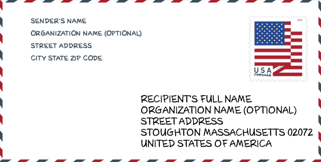
Envelope Example

This is an example of a US zip envelope. You can use a 5-digit zipcode or a detailed 9-digit zipcode to copy the mail in the following address format.
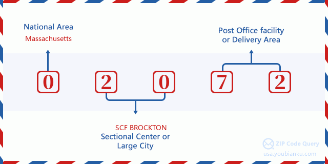
02072 Basic Meaning
What does each digit of ZIP Code 02072 stands for? The first digit designates a national area, which ranges from zero for the Northeast to nine for the far West. The 2-3 digits are the code of a sectional center facility in that region. The last two digits designate small post offices or postal zones.
Online Map

This is online map of the address Stoughton, Massachusetts, United States. You may use button to move and zoom in / out. The map information is for reference only.
Museum

This is the ZIP Code 02072 - Museum page list. Its detail Museum Name, Street, City, State, ZIP Code, Phone is as below.
- Name: STOUGHTON HISTORICAL SOCIETY
- Street: PO BOX 542
- City: STOUGHTON
- State: MA
- ZIP Code: 02072
- Phone: (781) 344-5456
Library

This is the ZIP Code 02072 - Library page list. Its detail Library Name, Address, City, State, ZIP Code, Phone is as below.
- Name: STOUGHTON PUBLIC LIBRARY
- Address: 84 PARK ST.
- City: STOUGHTON
- State: MA - Massachusetts
- ZIP Code: 02072
- Phone: (781) 344-2711
School

This is the ZIP Code 02072 - School page list. Its detail School Name, Address, City, State, ZIP Code is as below.
| School Name | Address | City | State | Grades | ZIP Code |
|---|---|---|---|---|---|
| Helen Hansen Elementary | 1800 Central Street | Stoughton | MA | UG | 02072 |
| Edwin A Jones Early Childhood Center | 137 Walnut Street | Stoughton | MA | UG | 02072 |
| Joseph H Gibbons | 235 Morton Street | Stoughton | MA | UG | 02072 |
| Joseph R Dawe Jr Elementary | 131 Pine Street | Stoughton | MA | UG | 02072 |
| South Elementary | 171 Ash Street | Stoughton | MA | UG | 02072 |
| Stoughton High | 232 Pearl Street | Stoughton | MA | UG | 02072 |
| O'Donnell Middle School | 211 Cushing Street | Stoughton | MA | UG | 02072 |
| Richard L. Wilkins Elementary School | 1322 Central Street | Stoughton | MA | UG | 02072 |
Population for ZIP Code 02072

What is the total population in ZIP Code 02072? Below is detail information.
- Population for ZIP Code 02072: 29,469
- 2010 Population: 26,999
The 2020 demographic statistics are in progress. The current population in ZIP code 02072 is 29,469, and the population in 2010 is 26,999.
Gender

In all the statistical population, the male population is 12,944, the female population is 14,055.
- Male Population: 12,944
- Female Population: 14,055
Race

In all the statistical population, the male population is 12,944, the female population is 14,055.
- White Population: 22,173
- Black Population: 3,362
- Hispanic Population: 876
- Asian Population: 1,157
- Hawaiian Population: 41
- Indian Population: 165
- Other Population: 880
Age

In all the statistical population, the White population is 22,173, the Black population is 3,362, the Hispanic population is 876, the Asian population is 1,157, the Hawaiian population is 41, the Indian Ppopulation is 165 and Other population is 880.
- Age's Median: 42.9
- Median of male age: 41.3
- Median of female age: 44.4
Households for ZIP Code 02072
ZIP code 02072 has 10,306 households, with an average number of 2.59 persons per household. The average income per household in Zip code 02072 is 79,421 USD, and the average house value is 333,700 USD.
- Households Per Zipcode: 10,306
- Persons Per Household: 2.59
- Average House Value: 333,700
- Income Per Household: 79,421
Geographic

The latitude of the Zip code 02072 is 42.118550, the longitude is -71.103346, and the elevation is 233. It has land area of 16.088 square miles, and water area of 0.374 square miles. The time zone for ZIP code 02072 is Eastern (GMT -05:00). Daylight saving time should be observed in the area where the zip code is located.
- Latitude: 42.118550
- Longitude: -71.103346
- Elevation: 233
- Land Area: 16.088
- Water Area: 0.374
- Time Zone: Eastern (GMT -05:00)
- Region: Northeast
- Division: New England
- Day Light Saving: Y
Congressional District

The Congressional District for ZIP code 02072 is Massachusetts's 07th|08th congressional district, the Congressional Land Area is 62.67|326.37 square mile.
- Congressional District: 07th|08th
- Congressional Land Area: 62.67|326.37
Delivery

In the ZIP code 02072, there are 11,378 residential delivery mailboxes and centralized units, and 990 commercial delivery mailbox and centralized units, 7,801 single family deliveries and 2,950 multifamily deliveries, and the box count is 12,758. The main post office has city delivery carrier routes for the ZIP code 02072.
- Delivery Residential: 11,378
- Delivery Business: 990
- Delivery Total: 12,758
- Single Family Delivery Units: 7,801
- Multi Family Delivery Units: 2,950
- City Delivery Indicator: Y
Business

In ZIP code 02072, the number of business is 938, the number of employee is 12,766, the business first quarter payroll is 149,645,000 USD, the business annual payroll is 632,403,000 USD.
- Number Of Businesses: 938
- Number Of Employees: 12,766
- Business First Quarter Payroll: 149,645,000
- Business Annual Payroll: 632,403,000


Add new comment