United States ZIP Code: 02090
This is the Massachusetts ZIP Code 02090 page list. Its detail State, County, City, Longitude, Latitude, Envelope Example, Population is as below.
 for ZIP code 02090, showcasing postal theme with stylized Norfolk County map, Massachusetts symbols, and natural beauty elements.")
ZIP Code 02090 Information

-
-
Country:
U.S. - United States
State:
State FIPS:
25
ZIP Code:
02090
ZIP Type:
S (Standard)
❓What does S (Standard) mean? A "standard" ZIP Code is what most people think of when they talk about ZIP Codes - essentially a town, city, or a division of a city that has mail service.
ZIP Code 02090 - City

This is the city information corresponding to 02090:
| State | County | City | City Type ?In many cases, a ZIP Code can have multiple "names", meaning cities, towns, or subdivisions, in its boundaries. However, it will ALWAYS have exactly 1 "default" name. D - Default - This is the "preferred" name - by the USPS - for a city. Each ZIP Code has one - and only one - "default" name. In most cases, this is what people who live in that area call the city as well. A - Acceptable - This name can be used for mailing purposes. Often times alternative names are large neighborhoods or sections of the city/town. In some cases a ZIP Code may have several "acceptable" names which is used to group towns under one ZIP Code. N - Not Acceptable - A "not acceptable" name is, in many cases, a nickname that residents give that location. According to the USPS, you should NOT send mail to that ZIP Code using the "not acceptable" name when mailing. | ZIP Code |
|---|---|---|---|---|
| MA | Norfolk | Islington | N (Not Acceptable) | 02090 |
| MA | Norfolk | Westwood | D (Default) | 02090 |
❓What does D (Default) mean? This is the "preferred" name - by the USPS - for a city. Each ZIP Code has one - and only one - "default" name. In most cases, this is what people who live in that area call the city as well.
❓What does N (Not Acceptable) mean? A "not acceptable" name is, in many cases, a nickname that residents give that location. According to the USPS, you should NOT send mail to that ZIP Code using the "not acceptable" name when mailing.
ZIP Code 02090 Plus 4
ZIP Code 5 plus 4 is the extension of 5-digit zip code, It can be used to locate a more detailed location. The last four digits designate segment or one side of a street or an apartment. You can find the ZIP+4 code and corresponding address of the zip code 02090 below.
| ZIP Code 5 Plus 4 | Address |
|---|---|
| 02090-0001 | PO BOX 1, WESTWOOD, MA |
| 02090-0201 | PO BOX 201, WESTWOOD, MA |
| 02090-0341 | PO BOX 341, WESTWOOD, MA |
| 02090-0461 | PO BOX 461, WESTWOOD, MA |
| 02090-0681 | PO BOX 681, WESTWOOD, MA |
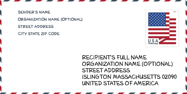
Envelope Example

This is an example of a US zip envelope. You can use a 5-digit zipcode or a detailed 9-digit zipcode to copy the mail in the following address format.
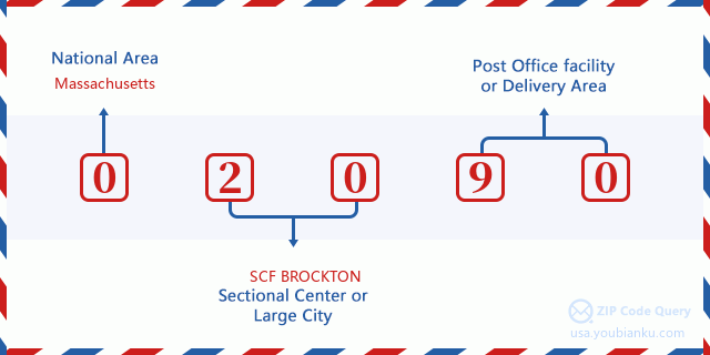
02090 Basic Meaning
What does each digit of ZIP Code 02090 stands for? The first digit designates a national area, which ranges from zero for the Northeast to nine for the far West. The 2-3 digits are the code of a sectional center facility in that region. The last two digits designate small post offices or postal zones.
Online Map

This is online map of the address Westwood, Massachusetts, United States. You may use button to move and zoom in / out. The map information is for reference only.
Hospital

This is the ZIP Code 02090 - Hospital page list. Its detail Hospital Name, Street, City, State, ZIP Code, Phone is as below.
- Name: WESTWOOD PEMBROKE HEALTH SYSTEMS
- Address: WESTWOOD
- City: 45 CLAPBOARDTREE STREET
- State: MA
- ZIP Code: 02090
- Phone: (617) 762-7764
Library

This is the ZIP Code 02090 - Library page list. Its detail Library Name, Address, City, State, ZIP Code, Phone is as below.
| Name | Address | City | State | ZIP Code | Phone |
|---|---|---|---|---|---|
| ISLINGTON BRANCH LIBRARY | 280 WASHINGTON STREET | WESTWOOD | MA | 02090 | (617) 326-5914 |
| WESTWOOD PUBLIC LIBRARY | 660 HIGH ST. | WESTWOOD | MA | 02090 | (781) 326-7562 |
| WESTWOOD PUBLIC LIBRARY | 668 HIGH ST. | WESTWOOD | MA | 02090 | (781) 326-7562 |
School

This is the ZIP Code 02090 - School page list. Its detail School Name, Address, City, State, ZIP Code is as below.
| School Name | Address | City | State | Grades | ZIP Code |
|---|---|---|---|---|---|
| Deerfield School | 72 Deerfield Avenue | Westwood | MA | UG | 02090 |
| Downey | 250 Downey Street | Westwood | MA | UG | 02090 |
| E W Thurston Middle | 850 High Street | Westwood | MA | UG | 02090 |
| Martha Jones | 80 Martha Jones Rd | Westwood | MA | UG | 02090 |
| Paul Hanlon | 790 Gay Street | Westwood | MA | UG | 02090 |
| Westwood High | 200 Nahatan Street | Westwood | MA | UG | 02090 |
| William E Sheehan | 549 Pond Street | Westwood | MA | UG | 02090 |
| Westwood Integrated Preschool | 200 Nahatan Street | Westwood | MA | UG | 02090 |
Population for ZIP Code 02090

What is the total population in ZIP Code 02090? Below is detail information.
- Population for ZIP Code 02090: 16,616
- 2010 Population: 14,636
The 2020 demographic statistics are in progress. The current population in ZIP code 02090 is 16,616, and the population in 2010 is 14,636.
Gender

In all the statistical population, the male population is 6,971, the female population is 7,665.
- Male Population: 6,971
- Female Population: 7,665
Race

In all the statistical population, the male population is 6,971, the female population is 7,665.
- White Population: 13,706
- Black Population: 169
- Hispanic Population: 237
- Asian Population: 820
- Hawaiian Population: 1
- Indian Population: 20
- Other Population: 71
Age

In all the statistical population, the White population is 13,706, the Black population is 169, the Hispanic population is 237, the Asian population is 820, the Hawaiian population is 1, the Indian Ppopulation is 20 and Other population is 71.
- Age's Median: 43.9
- Median of male age: 43.2
- Median of female age: 44.6
Households for ZIP Code 02090
ZIP code 02090 has 5,256 households, with an average number of 2.78 persons per household. The average income per household in Zip code 02090 is 155,887 USD, and the average house value is 703,000 USD.
- Households Per Zipcode: 5,256
- Persons Per Household: 2.78
- Average House Value: 703,000
- Income Per Household: 155,887
Geographic

The latitude of the Zip code 02090 is 42.221173, the longitude is -71.199439, and the elevation is 171. It has land area of 10.896 square miles, and water area of 0.29 square miles. The time zone for ZIP code 02090 is Eastern (GMT -05:00). Daylight saving time should be observed in the area where the zip code is located.
- Latitude: 42.221173
- Longitude: -71.199439
- Elevation: 171
- Land Area: 10.896
- Water Area: 0.29
- Time Zone: Eastern (GMT -05:00)
- Region: Northeast
- Division: New England
- Day Light Saving: Y
Congressional District

The Congressional District for ZIP code 02090 is Massachusetts's 08th congressional district, the Congressional Land Area is 326.37 square mile.
- Congressional District: 08th
- Congressional Land Area: 326.37
Delivery

In the ZIP code 02090, there are 5,977 residential delivery mailboxes and centralized units, and 424 commercial delivery mailbox and centralized units, 4,687 single family deliveries and 1,284 multifamily deliveries, and the box count is 7,620. The main post office has city delivery carrier routes for the ZIP code 02090.
- Delivery Residential: 5,977
- Delivery Business: 424
- Delivery Total: 7,620
- Single Family Delivery Units: 4,687
- Multi Family Delivery Units: 1,284
- City Delivery Indicator: Y
Business

In ZIP code 02090, the number of business is 513, the number of employee is 15,173, the business first quarter payroll is 300,418,000 USD, the business annual payroll is 1,007,849,000 USD.
- Number Of Businesses: 513
- Number Of Employees: 15,173
- Business First Quarter Payroll: 300,418,000
- Business Annual Payroll: 1,007,849,000


Add new comment