United States ZIP Code: 02360
This is the Massachusetts ZIP Code 02360 page list. Its detail State, County, City, Longitude, Latitude, Envelope Example, Population is as below.

ZIP Code 02360 Information

-
-
Country:
U.S. - United States
State:
State FIPS:
25
ZIP Code:
02360
ZIP Type:
S (Standard)
❓What does S (Standard) mean? A "standard" ZIP Code is what most people think of when they talk about ZIP Codes - essentially a town, city, or a division of a city that has mail service.
-


-
Iconic US Landmark Legacy Designs
Get PNG, SVG, EPS, AI, PDF Versions at Just $0.1
 Download Now
-


ZipCodeCraft
ZIP Code 02360 - City

This is the city information corresponding to 02360:
| State | County | City | City Type ?In many cases, a ZIP Code can have multiple "names", meaning cities, towns, or subdivisions, in its boundaries. However, it will ALWAYS have exactly 1 "default" name. D - Default - This is the "preferred" name - by the USPS - for a city. Each ZIP Code has one - and only one - "default" name. In most cases, this is what people who live in that area call the city as well. A - Acceptable - This name can be used for mailing purposes. Often times alternative names are large neighborhoods or sections of the city/town. In some cases a ZIP Code may have several "acceptable" names which is used to group towns under one ZIP Code. N - Not Acceptable - A "not acceptable" name is, in many cases, a nickname that residents give that location. According to the USPS, you should NOT send mail to that ZIP Code using the "not acceptable" name when mailing. | ZIP Code |
|---|---|---|---|---|
| MA | Plymouth | Cedarville | N (Not Acceptable) | 02360 |
| MA | Plymouth | Plymouth | D (Default) | 02360 |
❓What does D (Default) mean? This is the "preferred" name - by the USPS - for a city. Each ZIP Code has one - and only one - "default" name. In most cases, this is what people who live in that area call the city as well.
❓What does N (Not Acceptable) mean? A "not acceptable" name is, in many cases, a nickname that residents give that location. According to the USPS, you should NOT send mail to that ZIP Code using the "not acceptable" name when mailing.
ZIP Code 02360 Plus 4
ZIP Code 5 plus 4 is the extension of 5-digit zip code, It can be used to locate a more detailed location. The last four digits designate segment or one side of a street or an apartment. You can find the ZIP+4 code and corresponding address of the zip code 02360 below.
| ZIP Code 5 Plus 4 | Address |
|---|---|
| 02360-1000 | 101 BRENTWOOD CIR, PLYMOUTH, MA |
| 02360-1001 | 1 ASIAF WAY, PLYMOUTH, MA |
| 02360-1002 | 2 ASIAF WAY, PLYMOUTH, MA |
| 02360-1003 | 1 BEACH ST, PLYMOUTH, MA |
| 02360-1004 | 2 BEACH ST, PLYMOUTH, MA |
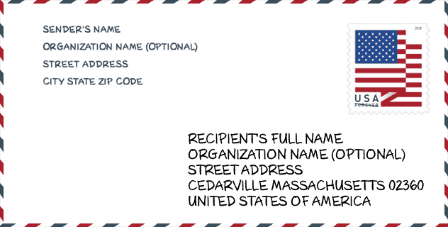
Envelope Example

This is an example of a US zip envelope. You can use a 5-digit zipcode or a detailed 9-digit zipcode to copy the mail in the following address format.
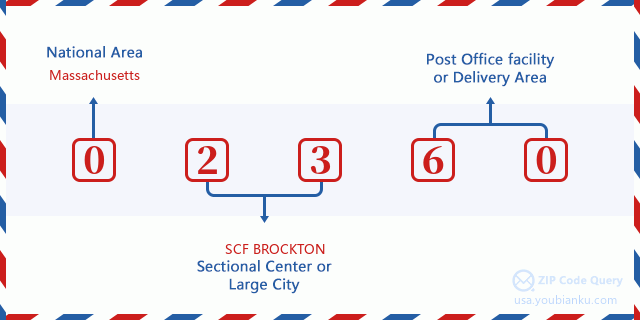
02360 Basic Meaning
What does each digit of ZIP Code 02360 stands for? The first digit designates a national area, which ranges from zero for the Northeast to nine for the far West. The 2-3 digits are the code of a sectional center facility in that region. The last two digits designate small post offices or postal zones.
Online Map

This is online map of the address Plymouth, Massachusetts, United States. You may use button to move and zoom in / out. The map information is for reference only.
University

This is the ZIP Code 02360 - University page list. Its detail university Name, Street, City, State, ZIP Code, Phone is as below.
| Name | Street | City | State | ZIP Code | Phone |
| Spa Tech Institute-Plymouth | 59 Industrial Park Rd | Plymouth | MA | 02360 | (508) 747-3130 |
Hospital

This is the ZIP Code 02360 - Hospital page list. Its detail Hospital Name, Street, City, State, ZIP Code, Phone is as below.
- Name: BETH ISRAEL DEACONESS HOSPITAL PLYMOUTH
- Address: PLYMOUTH
- City: 275 SANDWICH STREET
- State: MA
- ZIP Code: 02360
- Phone: (508) 746-2000
Museum

This is the ZIP Code 02360 - Museum page list. Its detail Museum Name, Street, City, State, ZIP Code, Phone is as below.
| Name | Street | City | State | ZIP Code | Phone |
| PILGRAM JOHN HOWLAND SOCIETY | 33 SANDWICH ST | PLYMOUTH | MA | 02360 | (508) 746-9590 |
| PLYMOUTH 1749 COURT HOUSE MUSEUM | 11 LINCOLN ST | PLYMOUTH | MA | 02360 | (508) 830-4075 |
| 1749 COURT HOUSE MUSEUM | 132 SOUTH STREET | PLYMOUTH | MA | 02360 | (508) 830-4075 |
Library

This is the ZIP Code 02360 - Library page list. Its detail Library Name, Address, City, State, ZIP Code, Phone is as below.
- Name: MANOMET BRANCH LIBRARY
- Address: 12 STRAND AVE.
- City: MANOMET
- State: MA - Massachusetts
- ZIP Code: 02360
- Phone: (508) 830-4185
School
This is the ZIP Code 02360 - School page list. Its detail School Name, Address, City, State, ZIP Code is as below.
| School Name | Address | City | State | Grades | ZIP Code |
|---|---|---|---|---|---|
| Rising Tide Charter Public School | 59 Armstrong Road | Plymouth | MA | UG | 02360 |
| Map Academy Charter School | 11 Resnik Road | Plymouth | MA | UG | 02360 |
| Plymouth Early Childhood Center | 117 Long Pond Road | Plymouth | MA | UG | 02360 |
| Plymouth North High | 41 Obery Street | Plymouth | MA | UG | 02360 |
| Plymouth South High | 490 Long Pond Road | Plymouth | MA | UG | 02360 |
| Plymouth South Middle | 488 Long Pond Road | Plymouth | MA | UG | 02360 |
| Cold Spring | 25 Alden Street | Plymouth | MA | UG | 02360 |
| Federal Furnace School | 860 Federal Furnace Road | Plymouth | MA | UG | 02360 |
| Hedge | 258 Standish Avenue | Plymouth | MA | UG | 02360 |
| Indian Brook | 1181 State Rd | Plymouth | MA | UG | 02360 |
| Manomet Elementary | 70 Manomet Point Rd | Plymouth | MA | UG | 02360 |
| Nathaniel Morton Elementary | 6 Lincoln Street | Plymouth | MA | UG | 02360 |
| South Elementary | 178 Bourne Rd | Plymouth | MA | UG | 02360 |
| West Elementary | 170 Plympton Rd | Plymouth | MA | UG | 02360 |
| Plymouth Commun Intermediate | 117 Long Pond Road | Plymouth | MA | UG | 02360 |
Population for ZIP Code 02360

What is the total population in ZIP Code 02360? Below is detail information.
- Population for ZIP Code 02360: 65,012
- 2010 Population: 56,271
The 2020 demographic statistics are in progress. The current population in ZIP code 02360 is 65,012, and the population in 2010 is 56,271.
Gender

In all the statistical population, the male population is 27,714, the female population is 28,557.
- Male Population: 27,714
- Female Population: 28,557
Race

In all the statistical population, the male population is 27,714, the female population is 28,557.
- White Population: 53,705
- Black Population: 1,447
- Hispanic Population: 986
- Asian Population: 752
- Hawaiian Population: 51
- Indian Population: 452
- Other Population: 938
Age

In all the statistical population, the White population is 53,705, the Black population is 1,447, the Hispanic population is 986, the Asian population is 752, the Hawaiian population is 51, the Indian Ppopulation is 452 and Other population is 938.
- Age's Median: 41.5
- Median of male age: 39.8
- Median of female age: 43.1
Households for ZIP Code 02360
ZIP code 02360 has 21,269 households, with an average number of 2.55 persons per household. The average income per household in Zip code 02360 is 87,595 USD, and the average house value is 359,300 USD.
- Households Per Zipcode: 21,269
- Persons Per Household: 2.55
- Average House Value: 359,300
- Income Per Household: 87,595
Geographic

The latitude of the Zip code 02360 is 41.873369, the longitude is -70.639662, and the elevation is 178. It has land area of 95.486 square miles, and water area of 13.161 square miles. The time zone for ZIP code 02360 is Eastern (GMT -05:00). Daylight saving time should be observed in the area where the zip code is located.
- Latitude: 41.873369
- Longitude: -70.639662
- Elevation: 178
- Land Area: 95.486
- Water Area: 13.161
- Time Zone: Eastern (GMT -05:00)
- Region: Northeast
- Division: New England
- Day Light Saving: Y
Congressional District

The Congressional District for ZIP code 02360 is Massachusetts's 09th congressional district, the Congressional Land Area is 1214.74 square mile.
- Congressional District: 09th
- Congressional Land Area: 1214.74
Delivery

In the ZIP code 02360, there are 25,495 residential delivery mailboxes and centralized units, and 1,888 commercial delivery mailbox and centralized units, 17,533 single family deliveries and 3,960 multifamily deliveries, and the box count is 27,859. The main post office has city delivery carrier routes for the ZIP code 02360.
- Delivery Residential: 25,495
- Delivery Business: 1,888
- Delivery Total: 27,859
- Single Family Delivery Units: 17,533
- Multi Family Delivery Units: 3,960
- City Delivery Indicator: Y
Business

In ZIP code 02360, the number of business is 1,575, the number of employee is 24,227, the business first quarter payroll is 269,643,000 USD, the business annual payroll is 1,147,541,000 USD.
- Number Of Businesses: 1,575
- Number Of Employees: 24,227
- Business First Quarter Payroll: 269,643,000
- Business Annual Payroll: 1,147,541,000


Add new comment