United States ZIP Code: 02453
This is the Massachusetts ZIP Code 02453 page list. Its detail State, County, City, Longitude, Latitude, Envelope Example, Population is as below.

ZIP Code 02453 Information

-
-
Country:
U.S. - United States
State:
State FIPS:
25
ZIP Code:
02453
ZIP Type:
S (Standard)
❓What does S (Standard) mean? A "standard" ZIP Code is what most people think of when they talk about ZIP Codes - essentially a town, city, or a division of a city that has mail service.
ZIP Code 02453 - City

This is the city information corresponding to 02453:
| State | County | City | City Type ?In many cases, a ZIP Code can have multiple "names", meaning cities, towns, or subdivisions, in its boundaries. However, it will ALWAYS have exactly 1 "default" name. D - Default - This is the "preferred" name - by the USPS - for a city. Each ZIP Code has one - and only one - "default" name. In most cases, this is what people who live in that area call the city as well. A - Acceptable - This name can be used for mailing purposes. Often times alternative names are large neighborhoods or sections of the city/town. In some cases a ZIP Code may have several "acceptable" names which is used to group towns under one ZIP Code. N - Not Acceptable - A "not acceptable" name is, in many cases, a nickname that residents give that location. According to the USPS, you should NOT send mail to that ZIP Code using the "not acceptable" name when mailing. | ZIP Code |
|---|---|---|---|---|
| MA | Middlesex | South Waltham | A (Acceptable) | 02453 |
| MA | Middlesex | Waltham | D (Default) | 02453 |
❓What does D (Default) mean? This is the "preferred" name - by the USPS - for a city. Each ZIP Code has one - and only one - "default" name. In most cases, this is what people who live in that area call the city as well.
❓What does A (Acceptable) mean? This name can be used for mailing purposes. Often times alternative names are large neighborhoods or sections of the city/town. In some cases a ZIP Code may have several "acceptable" names which is used to group towns under one ZIP Code.
ZIP Code 02453 Plus 4
ZIP Code 5 plus 4 is the extension of 5-digit zip code, It can be used to locate a more detailed location. The last four digits designate segment or one side of a street or an apartment. You can find the ZIP+4 code and corresponding address of the zip code 02453 below.
| ZIP Code 5 Plus 4 | Address |
|---|---|
| 02453-0054 | PO BOX 532254, WALTHAM, MA |
| 02453-0055 | PO BOX 532255, WALTHAM, MA |
| 02453-0400 | 51 CUSHING ST #00000001 , WALTHAM, MA |
| 02453-0401 | 383 MOODY ST, WALTHAM, MA |
| 02453-0402 | 439 MOODY ST, WALTHAM, MA |
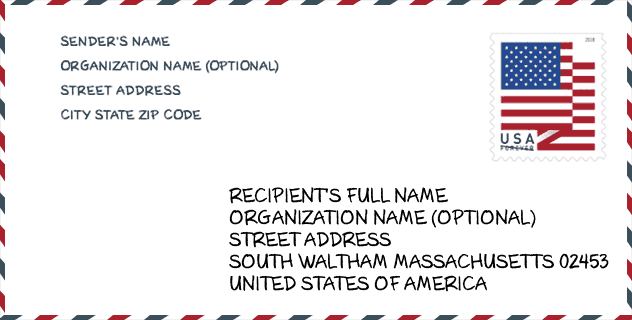
Envelope Example

This is an example of a US zip envelope. You can use a 5-digit zipcode or a detailed 9-digit zipcode to copy the mail in the following address format.
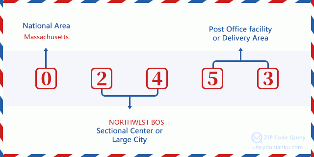
02453 Basic Meaning
What does each digit of ZIP Code 02453 stands for? The first digit designates a national area, which ranges from zero for the Northeast to nine for the far West. The 2-3 digits are the code of a sectional center facility in that region. The last two digits designate small post offices or postal zones.
Online Map

This is online map of the address Waltham, Massachusetts, United States. You may use button to move and zoom in / out. The map information is for reference only.
Hospital

This is the ZIP Code 02453 - Hospital page list. Its detail Hospital Name, Street, City, State, ZIP Code, Phone is as below.
- Name: WALDEN BEHAVIORAL CARE, LLC
- Address: WALTHAM
- City: 9 HOPE AVENUE
- State: MA
- ZIP Code: 02453
- Phone: (781) 647-6727
Museum

This is the ZIP Code 02453 - Museum page list. Its detail Museum Name, Street, City, State, ZIP Code, Phone is as below.
| Name | Street | City | State | ZIP Code | Phone |
| WALTHAM HISTORICAL SOCIETY | 190 MOODY STREET | WALTHAM | MA | 02453 | (781) 891-5815 |
| ROSE ART MUSEUM | 415 SOUTH STREET | WALTHAM | MA | 02453 | (781) 736-3434 |
School

This is the ZIP Code 02453 - School page list. Its detail School Name, Address, City, State, ZIP Code is as below.
| School Name | Address | City | State | Grades | ZIP Code |
|---|---|---|---|---|---|
| Henry Whittemore Elementary School | 30 Parmenter Road | Waltham | MA | UG | 02453 |
| James Fitzgerald Elementary School | 140 Beal Road | Waltham | MA | UG | 02453 |
| William F. Stanley Elementary School | 250 South Street | Waltham | MA | UG | 02453 |
| John W. McDevitt Middle School | 75 Church Street | Waltham | MA | UG | 02453 |
| Waltham Public Schools Dual Language Program | 510 Moody Street | Waltham | MA | UG | 02453 |
Population for ZIP Code 02453

What is the total population in ZIP Code 02453? Below is detail information.
- Population for ZIP Code 02453: 29,279
- 2010 Population: 28,968
The 2020 demographic statistics are in progress. The current population in ZIP code 02453 is 29,279, and the population in 2010 is 28,968.
Gender

In all the statistical population, the male population is 14,599, the female population is 14,369.
- Male Population: 14,599
- Female Population: 14,369
Race

In all the statistical population, the male population is 14,599, the female population is 14,369.
- White Population: 21,858
- Black Population: 1,857
- Hispanic Population: 5,666
- Asian Population: 2,723
- Hawaiian Population: 119
- Indian Population: 183
- Other Population: 3,053
Age

In all the statistical population, the White population is 21,858, the Black population is 1,857, the Hispanic population is 5,666, the Asian population is 2,723, the Hawaiian population is 119, the Indian Ppopulation is 183 and Other population is 3,053.
- Age's Median: 32.2
- Median of male age: 31.7
- Median of female age: 32.7
Households for ZIP Code 02453
ZIP code 02453 has 11,375 households, with an average number of 2.29 persons per household. The average income per household in Zip code 02453 is 76,856 USD, and the average house value is 502,200 USD.
- Households Per Zipcode: 11,375
- Persons Per Household: 2.29
- Average House Value: 502,200
- Income Per Household: 76,856
Geographic

The latitude of the Zip code 02453 is 42.369984, the longitude is -71.232748, and the elevation is 63. It has land area of 3.508 square miles, and water area of 0.279 square miles. The time zone for ZIP code 02453 is Eastern (GMT -05:00). Daylight saving time should be observed in the area where the zip code is located.
- Latitude: 42.369984
- Longitude: -71.232748
- Elevation: 63
- Land Area: 3.508
- Water Area: 0.279
- Time Zone: Eastern (GMT -05:00)
- Region: Northeast
- Division: New England
- Day Light Saving: Y
Congressional District

The Congressional District for ZIP code 02453 is Massachusetts's 04th|05th congressional district, the Congressional Land Area is 668.27|265.08 square mile.
- Congressional District: 04th|05th
- Congressional Land Area: 668.27|265.08
Delivery

In the ZIP code 02453, there are 12,786 residential delivery mailboxes and centralized units, and 1,047 commercial delivery mailbox and centralized units, 8,715 single family deliveries and 3,970 multifamily deliveries, and the box count is 14,483. The main post office has city delivery carrier routes for the ZIP code 02453.
- Delivery Residential: 12,786
- Delivery Business: 1,047
- Delivery Total: 14,483
- Single Family Delivery Units: 8,715
- Multi Family Delivery Units: 3,970
- City Delivery Indicator: Y
Business

In ZIP code 02453, the number of business is 839, the number of employee is 17,115, the business first quarter payroll is 352,736,000 USD, the business annual payroll is 1,302,530,000 USD.
- Number Of Businesses: 839
- Number Of Employees: 17,115
- Business First Quarter Payroll: 352,736,000
- Business Annual Payroll: 1,302,530,000


Add new comment