United States ZIP Code: 04270
This is the Maine ZIP Code 04270 page list. Its detail State, County, City, Longitude, Latitude, Envelope Example, Population is as below.

ZIP Code 04270 Information

-
-
Country:
U.S. - United States
State:
State FIPS:
23
Area Code:
ZIP Code:
04270
ZIP Type:
S (Standard)
❓What does S (Standard) mean? A "standard" ZIP Code is what most people think of when they talk about ZIP Codes - essentially a town, city, or a division of a city that has mail service.
-


-
Iconic US Landmark Legacy Designs
Get PNG, SVG, EPS, AI, PDF Versions at Just $0.1
 Download Now
-


ZipCodeCraft
ZIP Code 04270 - City

This is the city information corresponding to 04270:
| State | County | City | City Type ?In many cases, a ZIP Code can have multiple "names", meaning cities, towns, or subdivisions, in its boundaries. However, it will ALWAYS have exactly 1 "default" name. D - Default - This is the "preferred" name - by the USPS - for a city. Each ZIP Code has one - and only one - "default" name. In most cases, this is what people who live in that area call the city as well. A - Acceptable - This name can be used for mailing purposes. Often times alternative names are large neighborhoods or sections of the city/town. In some cases a ZIP Code may have several "acceptable" names which is used to group towns under one ZIP Code. N - Not Acceptable - A "not acceptable" name is, in many cases, a nickname that residents give that location. According to the USPS, you should NOT send mail to that ZIP Code using the "not acceptable" name when mailing. | ZIP Code |
|---|---|---|---|---|
| ME | Oxford | Otisfield | A (Acceptable) | 04270 |
| ME | Oxford | Oxford | D (Default) | 04270 |
❓What does D (Default) mean? This is the "preferred" name - by the USPS - for a city. Each ZIP Code has one - and only one - "default" name. In most cases, this is what people who live in that area call the city as well.
❓What does A (Acceptable) mean? This name can be used for mailing purposes. Often times alternative names are large neighborhoods or sections of the city/town. In some cases a ZIP Code may have several "acceptable" names which is used to group towns under one ZIP Code.
ZIP Code 04270 Plus 4
ZIP Code 5 plus 4 is the extension of 5-digit zip code, It can be used to locate a more detailed location. The last four digits designate segment or one side of a street or an apartment. You can find the ZIP+4 code and corresponding address of the zip code 04270 below.
| ZIP Code 5 Plus 4 | Address |
|---|---|
| 04270-0001 | PO BOX 1, OXFORD, ME |
| 04270-0121 | PO BOX 121, OXFORD, ME |
| 04270-0181 | PO BOX 181, OXFORD, ME |
| 04270-0281 | PO BOX 281, OXFORD, ME |
| 04270-0401 | PO BOX 401, OXFORD, ME |
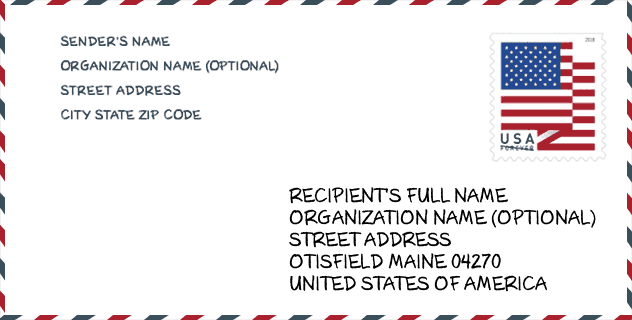
Envelope Example

This is an example of a US zip envelope. You can use a 5-digit zipcode or a detailed 9-digit zipcode to copy the mail in the following address format.
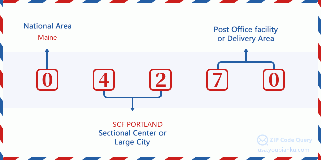
04270 Basic Meaning
What does each digit of ZIP Code 04270 stands for? The first digit designates a national area, which ranges from zero for the Northeast to nine for the far West. The 2-3 digits are the code of a sectional center facility in that region. The last two digits designate small post offices or postal zones.
Online Map

This is online map of the address Oxford, Maine, United States. You may use button to move and zoom in / out. The map information is for reference only.
Museum

This is the ZIP Code 04270 - Museum page list. Its detail Museum Name, Street, City, State, ZIP Code, Phone is as below.
| Name | Street | City | State | ZIP Code | Phone |
| WOODSTOCK HISTORICAL SOCIETY | ALLEN HILL ROAD | OXFORD | ME | 04270 | (207) 665-2450 |
| OTISFIELD HISTORICAL SOCIETY | 877 STATE ROUTE 121 | OTISFIELD | ME | 04270 | (207) 539-2521 |
Library

This is the ZIP Code 04270 - Library page list. Its detail Library Name, Address, City, State, ZIP Code, Phone is as below.
- Name: FREELAND HOLMES LIBRARY
- Address: 109 PLEASANT STREET
- City: OXFORD
- State: ME - Maine
- ZIP Code: 04270
- Phone: (207) 539-4016
School

This is the ZIP Code 04270 - School page list. Its detail School Name, Address, City, State, ZIP Code is as below.
| School Name | Address | City | State | Grades | ZIP Code |
|---|---|---|---|---|---|
| Otisfield Community School | 416 Powhattan Road | Otisfield | ME | UG | 04270 |
| Oxford Elementary School | 79 Pleasant Street | Oxford | ME | UG | 04270 |
Population for ZIP Code 04270

What is the total population in ZIP Code 04270? Below is detail information.
- Population for ZIP Code 04270: 6,449
- 2010 Population: 5,880
The 2020 demographic statistics are in progress. The current population in ZIP code 04270 is 6,449, and the population in 2010 is 5,880.
Gender

In all the statistical population, the male population is 2,970, the female population is 2,910.
- Male Population: 2,970
- Female Population: 2,910
Race

In all the statistical population, the male population is 2,970, the female population is 2,910.
- White Population: 5,818
- Black Population: 35
- Hispanic Population: 60
- Asian Population: 19
- Hawaiian Population: 4
- Indian Population: 92
- Other Population: 12
Age

In all the statistical population, the White population is 5,818, the Black population is 35, the Hispanic population is 60, the Asian population is 19, the Hawaiian population is 4, the Indian Ppopulation is 92 and Other population is 12.
- Age's Median: 43.1
- Median of male age: 42.1
- Median of female age: 43.8
Households for ZIP Code 04270
ZIP code 04270 has 2,361 households, with an average number of 2.49 persons per household. The average income per household in Zip code 04270 is 54,250 USD, and the average house value is 141,300 USD.
- Households Per Zipcode: 2,361
- Persons Per Household: 2.49
- Average House Value: 141,300
- Income Per Household: 54,250
Geographic

The latitude of the Zip code 04270 is 44.103769, the longitude is -70.502872, and the elevation is 323. It has land area of 78.643 square miles, and water area of 7.473 square miles. The time zone for ZIP code 04270 is Eastern (GMT -05:00). Daylight saving time should be observed in the area where the zip code is located.
- Latitude: 44.103769
- Longitude: -70.502872
- Elevation: 323
- Land Area: 78.643
- Water Area: 7.473
- Time Zone: Eastern (GMT -05:00)
- Region: Northeast
- Division: New England
- Day Light Saving: Y
Congressional District

The Congressional District for ZIP code 04270 is Maine's 2nd congressional district, the Congressional Land Area is 27557.4 square mile.
- Congressional District: 2nd
- Congressional Land Area: 27557.4
Delivery

In the ZIP code 04270, there are 2,590 residential delivery mailboxes and centralized units, and 117 commercial delivery mailbox and centralized units, 2,366 single family deliveries and 64 multifamily deliveries, and the box count is 3,311. The main post office does not have city delivery carrier routes for the ZIP code 04270.
- Delivery Residential: 2,590
- Delivery Business: 117
- Delivery Total: 3,311
- Single Family Delivery Units: 2,366
- Multi Family Delivery Units: 64
- City Delivery Indicator: N
Business

In ZIP code 04270, the number of business is 136, the number of employee is 1,740, the business first quarter payroll is 13,878,000 USD, the business annual payroll is 59,315,000 USD.
- Number Of Businesses: 136
- Number Of Employees: 1,740
- Business First Quarter Payroll: 13,878,000
- Business Annual Payroll: 59,315,000


Add new comment