United States ZIP Code: 06107
This is the Connecticut ZIP Code 06107 page list. Its detail State, County, City, Longitude, Latitude, Envelope Example, Population is as below.
ZIP Code 06107 Information

-
-
Country:
U.S. - United States
State:
State FIPS:
09
Area Code:
ZIP Code:
06107
ZIP Type:
S (Standard)
❓What does S (Standard) mean? A "standard" ZIP Code is what most people think of when they talk about ZIP Codes - essentially a town, city, or a division of a city that has mail service.
ZIP Code 06107 - City

This is the city information corresponding to 06107:
| State | County | City | City Type ?In many cases, a ZIP Code can have multiple "names", meaning cities, towns, or subdivisions, in its boundaries. However, it will ALWAYS have exactly 1 "default" name. D - Default - This is the "preferred" name - by the USPS - for a city. Each ZIP Code has one - and only one - "default" name. In most cases, this is what people who live in that area call the city as well. A - Acceptable - This name can be used for mailing purposes. Often times alternative names are large neighborhoods or sections of the city/town. In some cases a ZIP Code may have several "acceptable" names which is used to group towns under one ZIP Code. N - Not Acceptable - A "not acceptable" name is, in many cases, a nickname that residents give that location. According to the USPS, you should NOT send mail to that ZIP Code using the "not acceptable" name when mailing. | ZIP Code |
|---|---|---|---|---|
| CT | Hartford | Hartford | A (Acceptable) | 06107 |
| CT | Hartford | W Hartford | N (Not Acceptable) | 06107 |
| CT | Hartford | W Htfd | N (Not Acceptable) | 06107 |
| CT | Hartford | West Hartford | D (Default) | 06107 |
| CT | Hartford | West Hartfrd | A (Acceptable) | 06107 |
❓What does D (Default) mean? This is the "preferred" name - by the USPS - for a city. Each ZIP Code has one - and only one - "default" name. In most cases, this is what people who live in that area call the city as well.
❓What does A (Acceptable) mean? This name can be used for mailing purposes. Often times alternative names are large neighborhoods or sections of the city/town. In some cases a ZIP Code may have several "acceptable" names which is used to group towns under one ZIP Code.
❓What does N (Not Acceptable) mean? A "not acceptable" name is, in many cases, a nickname that residents give that location. According to the USPS, you should NOT send mail to that ZIP Code using the "not acceptable" name when mailing.
ZIP Code 06107 Plus 4
ZIP Code 5 plus 4 is the extension of 5-digit zip code, It can be used to locate a more detailed location. The last four digits designate segment or one side of a street or an apartment. You can find the ZIP+4 code and corresponding address of the zip code 06107 below.
| ZIP Code 5 Plus 4 | Address |
|---|---|
| 06107-1001 | 2 BEECHTREE LN, WEST HARTFORD, CT |
| 06107-1002 | 1 BEECHTREE LN, WEST HARTFORD, CT |
| 06107-1003 | 14 SQUIRREL HILL RD, WEST HARTFORD, CT |
| 06107-1004 | 1 SQUIRREL HILL RD, WEST HARTFORD, CT |
| 06107-1005 | 2 CEDAR LEDGE RD, WEST HARTFORD, CT |
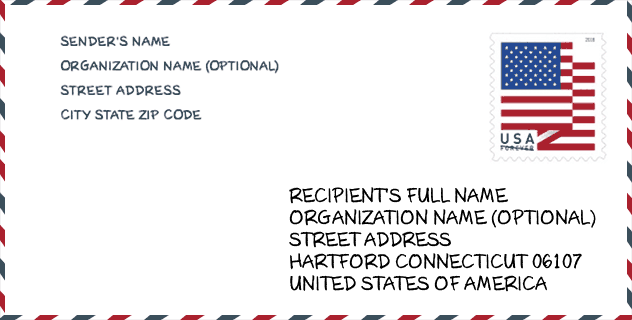
Envelope Example

This is an example of a US zip envelope. You can use a 5-digit zipcode or a detailed 9-digit zipcode to copy the mail in the following address format.
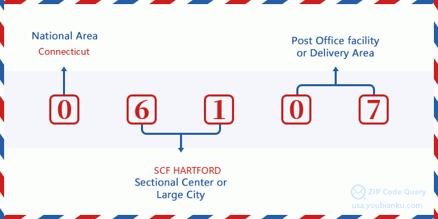
06107 Basic Meaning
What does each digit of ZIP Code 06107 stands for? The first digit designates a national area, which ranges from zero for the Northeast to nine for the far West. The 2-3 digits are the code of a sectional center facility in that region. The last two digits designate small post offices or postal zones.
Online Map

This is online map of the address West Hartfrd, Connecticut, United States. You may use button to move and zoom in / out. The map information is for reference only.
Museum

This is the ZIP Code 06107 - Museum page list. Its detail Museum Name, Street, City, State, ZIP Code, Phone is as below.
| Name | Street | City | State | ZIP Code | Phone |
| NOAH WEBSTER FOUNDATION | 227 SOUTH MAIN STREET | WEST HARTFORD | CT | 06107 | (860) 521-5362 |
| AMERICAN SCHOOL FOR THE DEAF MUSEUM & ARCHIVES | 139 N. MAIN ST. | WEST HARTFORD | CT | 06107 |
Library

This is the ZIP Code 06107 - Library page list. Its detail Library Name, Address, City, State, ZIP Code, Phone is as below.
- Name: WEST HARTFORD PUBLIC LIBRARY
- Address: 20 SOUTH MAIN ST.
- City: WEST HARTFORD
- State: CT - Connecticut
- ZIP Code: 06107
- Phone: (860) 561-6950
School

This is the ZIP Code 06107 - School page list. Its detail School Name, Address, City, State, ZIP Code is as below.
- School Name: Conard High School
- Address: 110 Beechwood Rd.
- City: West Hartford
- State: CT
- Grades: UG
- ZIP Code: 06107
Population for ZIP Code 06107

What is the total population in ZIP Code 06107? Below is detail information.
- Population for ZIP Code 06107: 19,372
- 2010 Population: 18,786
The 2020 demographic statistics are in progress. The current population in ZIP code 06107 is 19,372, and the population in 2010 is 18,786.
Gender

In all the statistical population, the male population is 8,886, the female population is 9,900.
- Male Population: 8,886
- Female Population: 9,900
Race

In all the statistical population, the male population is 8,886, the female population is 9,900.
- White Population: 17,266
- Black Population: 612
- Hispanic Population: 725
- Asian Population: 964
- Hawaiian Population: 15
- Indian Population: 75
- Other Population: 205
Age

In all the statistical population, the White population is 17,266, the Black population is 612, the Hispanic population is 725, the Asian population is 964, the Hawaiian population is 15, the Indian Ppopulation is 75 and Other population is 205.
- Age's Median: 43.8
- Median of male age: 42.3
- Median of female age: 45.0
Households for ZIP Code 06107
ZIP code 06107 has 7,554 households, with an average number of 2.46 persons per household. The average income per household in Zip code 06107 is 132,171 USD, and the average house value is 378,200 USD.
- Households Per Zipcode: 7,554
- Persons Per Household: 2.46
- Average House Value: 378,200
- Income Per Household: 132,171
Geographic

The latitude of the Zip code 06107 is 41.753138, the longitude is -72.758694, and the elevation is 154. It has land area of 6.524 square miles, and water area of 0.209 square miles. The time zone for ZIP code 06107 is Eastern (GMT -05:00). Daylight saving time should be observed in the area where the zip code is located.
- Latitude: 41.753138
- Longitude: -72.758694
- Elevation: 154
- Land Area: 6.524
- Water Area: 0.209
- Time Zone: Eastern (GMT -05:00)
- Region: Northeast
- Division: New England
- Day Light Saving: Y
Congressional District

The Congressional District for ZIP code 06107 is Connecticut's 1st|05th congressional district, the Congressional Land Area is 675.45|1248.16 square mile.
- Congressional District: 1st|05th
- Congressional Land Area: 675.45|1248.16
Delivery

In the ZIP code 06107, there are 7,875 residential delivery mailboxes and centralized units, and 760 commercial delivery mailbox and centralized units, 6,775 single family deliveries and 943 multifamily deliveries, and the box count is 9,204. The main post office has city delivery carrier routes for the ZIP code 06107.
- Delivery Residential: 7,875
- Delivery Business: 760
- Delivery Total: 9,204
- Single Family Delivery Units: 6,775
- Multi Family Delivery Units: 943
- City Delivery Indicator: Y
Business

In ZIP code 06107, the number of business is 659, the number of employee is 6,705, the business first quarter payroll is 88,108,000 USD, the business annual payroll is 347,446,000 USD.
- Number Of Businesses: 659
- Number Of Employees: 6,705
- Business First Quarter Payroll: 88,108,000
- Business Annual Payroll: 347,446,000


Add new comment