United States ZIP Code: 06484
This is the Connecticut ZIP Code 06484 page list. Its detail State, County, City, Longitude, Latitude, Envelope Example, Population is as below.

ZIP Code 06484 Information

-
-
Country:
U.S. - United States
State:
State FIPS:
09
ZIP Code:
06484
ZIP Type:
S (Standard)
❓What does S (Standard) mean? A "standard" ZIP Code is what most people think of when they talk about ZIP Codes - essentially a town, city, or a division of a city that has mail service.
ZIP Code 06484 - City

This is the city information corresponding to 06484:
| State | County | City | City Type ?In many cases, a ZIP Code can have multiple "names", meaning cities, towns, or subdivisions, in its boundaries. However, it will ALWAYS have exactly 1 "default" name. D - Default - This is the "preferred" name - by the USPS - for a city. Each ZIP Code has one - and only one - "default" name. In most cases, this is what people who live in that area call the city as well. A - Acceptable - This name can be used for mailing purposes. Often times alternative names are large neighborhoods or sections of the city/town. In some cases a ZIP Code may have several "acceptable" names which is used to group towns under one ZIP Code. N - Not Acceptable - A "not acceptable" name is, in many cases, a nickname that residents give that location. According to the USPS, you should NOT send mail to that ZIP Code using the "not acceptable" name when mailing. | ZIP Code |
|---|---|---|---|---|
| CT | Fairfield | Huntington | A (Acceptable) | 06484 |
| CT | Fairfield | Shelton | D (Default) | 06484 |
❓What does D (Default) mean? This is the "preferred" name - by the USPS - for a city. Each ZIP Code has one - and only one - "default" name. In most cases, this is what people who live in that area call the city as well.
❓What does A (Acceptable) mean? This name can be used for mailing purposes. Often times alternative names are large neighborhoods or sections of the city/town. In some cases a ZIP Code may have several "acceptable" names which is used to group towns under one ZIP Code.
ZIP Code 06484 Plus 4
ZIP Code 5 plus 4 is the extension of 5-digit zip code, It can be used to locate a more detailed location. The last four digits designate segment or one side of a street or an apartment. You can find the ZIP+4 code and corresponding address of the zip code 06484 below.
| ZIP Code 5 Plus 4 | Address |
|---|---|
| 06484-0001 | PO BOX 1, SHELTON, CT |
| 06484-0161 | PO BOX 161, SHELTON, CT |
| 06484-0321 | PO BOX 321, SHELTON, CT |
| 06484-0487 | PO BOX 487, SHELTON, CT |
| 06484-0491 | PO BOX 491, SHELTON, CT |
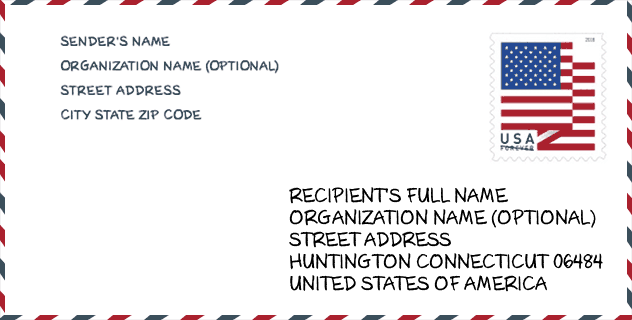
Envelope Example

This is an example of a US zip envelope. You can use a 5-digit zipcode or a detailed 9-digit zipcode to copy the mail in the following address format.
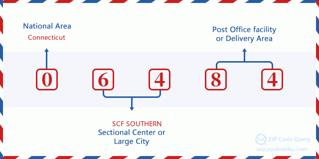
06484 Basic Meaning
What does each digit of ZIP Code 06484 stands for? The first digit designates a national area, which ranges from zero for the Northeast to nine for the far West. The 2-3 digits are the code of a sectional center facility in that region. The last two digits designate small post offices or postal zones.
Online Map

This is online map of the address Shelton, Connecticut, United States. You may use button to move and zoom in / out. The map information is for reference only.
University

This is the ZIP Code 06484 - University page list. Its detail university Name, Street, City, State, ZIP Code, Phone is as below.
| Name | Street | City | State | ZIP Code | Phone |
| Lincoln Technical Institute-Shelton | 8 Progress Drive | Shelton | CT | 06484 | (203) 929-0592 x45800 |
Museum

This is the ZIP Code 06484 - Museum page list. Its detail Museum Name, Street, City, State, ZIP Code, Phone is as below.
| Name | Street | City | State | ZIP Code | Phone |
| BRIDGEPORT FIREFIGHTERS HISTORICAL SOCIETY | 336 HUNTINGTON ST | SHELTON | CT | 06484 | |
| KIDNETIC CLUBHOUSE | 94 POPLAR DRIVE | HUNTINGTON | CT | 06484 | (203) 209-9771 |
Library

This is the ZIP Code 06484 - Library page list. Its detail Library Name, Address, City, State, ZIP Code, Phone is as below.
| Name | Address | City | State | ZIP Code | Phone |
|---|---|---|---|---|---|
| HUNTINGTON BRANCH | 41 CHURCH ST. | SHELTON | CT | 06484 | (203) 926-0111 |
| PLUMB MEMORIAL LIBRARY | 65 WOOSTER ST. | SHELTON | CT | 06484 | (203) 924-1580 |
School
This is the ZIP Code 06484 - School page list. Its detail School Name, Address, City, State, ZIP Code is as below.
- School Name: Perry Hill Elementary School
- Address: 60 Perry Hill Road
- City: Shelton
- State: CT
- Grades: UG
- ZIP Code: 06484
Population for ZIP Code 06484

What is the total population in ZIP Code 06484? Below is detail information.
- Population for ZIP Code 06484: 43,457
- 2010 Population: 39,559
The 2020 demographic statistics are in progress. The current population in ZIP code 06484 is 43,457, and the population in 2010 is 39,559.
Gender

In all the statistical population, the male population is 19,184, the female population is 20,375.
- Male Population: 19,184
- Female Population: 20,375
Race

In all the statistical population, the male population is 19,184, the female population is 20,375.
- White Population: 36,390
- Black Population: 1,148
- Hispanic Population: 2,353
- Asian Population: 1,654
- Hawaiian Population: 29
- Indian Population: 167
- Other Population: 761
Age

In all the statistical population, the White population is 36,390, the Black population is 1,148, the Hispanic population is 2,353, the Asian population is 1,654, the Hawaiian population is 29, the Indian Ppopulation is 167 and Other population is 761.
- Age's Median: 44.4
- Median of male age: 43.2
- Median of female age: 45.5
Households for ZIP Code 06484
ZIP code 06484 has 15,325 households, with an average number of 2.55 persons per household. The average income per household in Zip code 06484 is 94,446 USD, and the average house value is 345,200 USD.
- Households Per Zipcode: 15,325
- Persons Per Household: 2.55
- Average House Value: 345,200
- Income Per Household: 94,446
Geographic

The latitude of the Zip code 06484 is 41.315669, the longitude is -73.134957, and the elevation is 556. It has land area of 30.631 square miles, and water area of 1.271 square miles. The time zone for ZIP code 06484 is Eastern (GMT -05:00). Daylight saving time should be observed in the area where the zip code is located.
- Latitude: 41.315669
- Longitude: -73.134957
- Elevation: 556
- Land Area: 30.631
- Water Area: 1.271
- Time Zone: Eastern (GMT -05:00)
- Region: Northeast
- Division: New England
- Day Light Saving: Y
Congressional District

The Congressional District for ZIP code 06484 is Connecticut's 3rd|04th congressional district, the Congressional Land Area is 470.34|460.73 square mile.
- Congressional District: 3rd|04th
- Congressional Land Area: 470.34|460.73
Delivery

In the ZIP code 06484, there are 17,042 residential delivery mailboxes and centralized units, and 1,184 commercial delivery mailbox and centralized units, 12,814 single family deliveries and 748 multifamily deliveries, and the box count is 18,953. The main post office has city delivery carrier routes for the ZIP code 06484.
- Delivery Residential: 17,042
- Delivery Business: 1,184
- Delivery Total: 18,953
- Single Family Delivery Units: 12,814
- Multi Family Delivery Units: 748
- City Delivery Indicator: Y
Business

In ZIP code 06484, the number of business is 1,129, the number of employee is 27,574, the business first quarter payroll is 560,371,000 USD, the business annual payroll is 2,048,659,000 USD.
- Number Of Businesses: 1,129
- Number Of Employees: 27,574
- Business First Quarter Payroll: 560,371,000
- Business Annual Payroll: 2,048,659,000


Add new comment