ZIP Code: 06606, Bridgeport, CT
ZIP Code 06606 is located in Bridgeport, Connecticut. Its detail State, County, City, Longitude, Latitude, Envelope Example, Population is as below.
ZIP Code 06606 Information

-
-
Country:
U.S. - United States
State:
County FIPS:
09001
City:
Area Code:
City Type ?In many cases, a ZIP Code can have multiple "names", meaning cities, towns, or subdivisions, in its boundaries. However, it will ALWAYS have exactly 1 "default" name. D - Default - This is the "preferred" name - by the USPS - for a city. Each ZIP Code has one - and only one - "default" name. In most cases, this is what people who live in that area call the city as well. A - Acceptable - This name can be used for mailing purposes. Often times alternative names are large neighborhoods or sections of the city/town. In some cases a ZIP Code may have several "acceptable" names which is used to group towns under one ZIP Code. N - Not Acceptable - A "not acceptable" name is, in many cases, a nickname that residents give that location. According to the USPS, you should NOT send mail to that ZIP Code using the "not acceptable" name when mailing.:
D (Default)
ZIP Code:
06606
❓What does D (Default) mean? This is the "preferred" name - by the USPS - for a city. Each ZIP Code has one - and only one - "default" name. In most cases, this is what people who live in that area call the city as well.
ZIP Code 06606 Plus 4
ZIP Code 5 plus 4 is the extension of 5-digit zip code, It can be used to locate a more detailed location. The last four digits designate segment or one side of a street or an apartment. You can find the ZIP+4 code and corresponding address of the zip code 06606 below.
| ZIP Code 5 Plus 4 | Address |
|---|---|
| 06606-0001 | PO BOX 6001, BRIDGEPORT, CT |
| 06606-0121 | PO BOX 6121, BRIDGEPORT, CT |
| 06606-0271 | PO BOX 6271, BRIDGEPORT, CT |
| 06606-0391 | PO BOX 6391, BRIDGEPORT, CT |
| 06606-0482 | PO BOX 6482, BRIDGEPORT, CT |
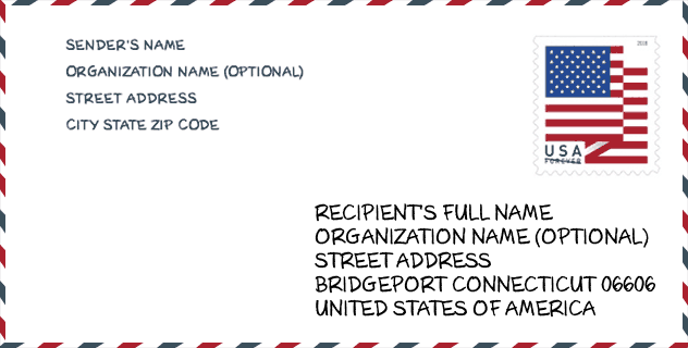
Envelope Example

This is an example of a US zip envelope. You can use a 5-digit zipcode or a detailed 9-digit zipcode to copy the mail in the following address format.
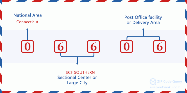
06606 Basic Meaning
What does each digit of ZIP Code 06606 stands for? The first digit designates a national area, which ranges from zero for the Northeast to nine for the far West. The 2-3 digits are the code of a sectional center facility in that region. The last two digits designate small post offices or postal zones.
Online Map

This is online map of the address Bridgeport, Connecticut, United States. You may use button to move and zoom in / out. The map information is for reference only.
University

This is the ZIP Code 06606 - University page list. Its detail university Name, Street, City, State, ZIP Code, Phone is as below.
| Name | Street | City | State | ZIP Code | Phone |
| Paier College | 84 iranistan Ave | Bridgeport | CT | 06606 | (203) 287-3031 |
Hospital

This is the ZIP Code 06606 - Hospital page list. Its detail Hospital Name, Street, City, State, ZIP Code, Phone is as below.
- Name: ST. VINCENT'S MEDICAL CENTER
- Address: BRIDGEPORT
- City: 2800 MAIN ST
- State: CT
- ZIP Code: 06606
- Phone: (203) 576-5551
Library

This is the ZIP Code 06606 - Library page list. Its detail Library Name, Address, City, State, ZIP Code, Phone is as below.
- Name: NORTH BRANCH LIBRARY
- Address: 3455 MADISON AVE.
- City: BRIDGEPORT
- State: CT - Connecticut
- ZIP Code: 06606
- Phone: (203) 576-8113
School
This is the ZIP Code 06606 - School page list. Its detail School Name, Address, City, State, ZIP Code is as below.
| School Name | Address | City | State | Grades | ZIP Code |
|---|---|---|---|---|---|
| Madison School | 376 Wayne St. | Bridgeport | CT | UG | 06606 |
| Interdistrict Discovery Magnet School | 4510 Park Avenue | Bridgeport | CT | UG | 06606 |
| Information Technology & Software Engineering Magnet High Sc | 840 Old Town Road | Bridgeport | CT | UG | 06606 |
| Biotechnology Research & Zoological Studies Magnet High Scho | 840 Old Town Road | Bridgeport | CT | UG | 06606 |
| Aerospace/Hydrospace Engineering and Physical Sciences Magne | 840 Old Town Road | Bridgeport | CT | UG | 06606 |
Population for ZIP Code 06606

What is the total population in ZIP Code 06606? Below is detail information.
- Population for ZIP Code 06606: 47,713
- 2010 Population: 46,236
The 2020 demographic statistics are in progress. The current population in ZIP code 06606 is 47,713, and the population in 2010 is 46,236.
Gender

In all the statistical population, the male population is 22,210, the female population is 24,026.
- Male Population: 22,210
- Female Population: 24,026
Race

In all the statistical population, the male population is 22,210, the female population is 24,026.
- White Population: 21,897
- Black Population: 16,350
- Hispanic Population: 14,178
- Asian Population: 1,446
- Hawaiian Population: 142
- Indian Population: 539
- Other Population: 7,871
Age

In all the statistical population, the White population is 21,897, the Black population is 16,350, the Hispanic population is 14,178, the Asian population is 1,446, the Hawaiian population is 142, the Indian Ppopulation is 539 and Other population is 7,871.
- Age's Median: 34.4
- Median of male age: 32.9
- Median of female age: 36.0
Households for ZIP Code 06606
ZIP code 06606 has 16,360 households, with an average number of 2.81 persons per household. The average income per household in Zip code 06606 is 56,607 USD, and the average house value is 173,000 USD.
- Households Per Zipcode: 16,360
- Persons Per Household: 2.81
- Average House Value: 173,000
- Income Per Household: 56,607
Geographic

The latitude of the Zip code 06606 is 41.208620, the longitude is -73.211428, and the elevation is 141. It has land area of 5.293 square miles, and water area of 0.135 square miles. The time zone for ZIP code 06606 is Eastern (GMT -05:00). Daylight saving time should be observed in the area where the zip code is located.
- Latitude: 41.208620
- Longitude: -73.211428
- Elevation: 141
- Land Area: 5.293
- Water Area: 0.135
- Time Zone: Eastern (GMT -05:00)
- Region: Northeast
- Division: New England
- Day Light Saving: Y
Congressional District

The Congressional District for ZIP code 06606 is Connecticut's 04th congressional district, the Congressional Land Area is 460.73 square mile.
- Congressional District: 04th
- Congressional Land Area: 460.73
Delivery

In the ZIP code 06606, there are 16,980 residential delivery mailboxes and centralized units, and 837 commercial delivery mailbox and centralized units, 13,156 single family deliveries and 2,821 multifamily deliveries, and the box count is 18,451. The main post office has city delivery carrier routes for the ZIP code 06606.
- Delivery Residential: 16,980
- Delivery Business: 837
- Delivery Total: 18,451
- Single Family Delivery Units: 13,156
- Multi Family Delivery Units: 2,821
- City Delivery Indicator: Y
Business

In ZIP code 06606, the number of business is 584, the number of employee is 7,788, the business first quarter payroll is 94,971,000 USD, the business annual payroll is 383,335,000 USD.
- Number Of Businesses: 584
- Number Of Employees: 7,788
- Business First Quarter Payroll: 94,971,000
- Business Annual Payroll: 383,335,000


Add new comment