ZIP Code: 06824, Fairfield, CT
ZIP Code 06824 is located in Fairfield, Connecticut. Its detail State, County, City, Longitude, Latitude, Envelope Example, Population is as below.
ZIP Code 06824 Information

-
-
Country:
U.S. - United States
State:
County FIPS:
09001
City:
City Type ?In many cases, a ZIP Code can have multiple "names", meaning cities, towns, or subdivisions, in its boundaries. However, it will ALWAYS have exactly 1 "default" name. D - Default - This is the "preferred" name - by the USPS - for a city. Each ZIP Code has one - and only one - "default" name. In most cases, this is what people who live in that area call the city as well. A - Acceptable - This name can be used for mailing purposes. Often times alternative names are large neighborhoods or sections of the city/town. In some cases a ZIP Code may have several "acceptable" names which is used to group towns under one ZIP Code. N - Not Acceptable - A "not acceptable" name is, in many cases, a nickname that residents give that location. According to the USPS, you should NOT send mail to that ZIP Code using the "not acceptable" name when mailing.:
D (Default)
ZIP Code:
06824
❓What does D (Default) mean? This is the "preferred" name - by the USPS - for a city. Each ZIP Code has one - and only one - "default" name. In most cases, this is what people who live in that area call the city as well.
-


-
Iconic US Landmark Legacy Designs
Get PNG, SVG, EPS, AI, PDF Versions at Just $0.1
 Download Now
-


ZipCodeCraft
ZIP Code 06824 Plus 4
ZIP Code 5 plus 4 is the extension of 5-digit zip code, It can be used to locate a more detailed location. The last four digits designate segment or one side of a street or an apartment. You can find the ZIP+4 code and corresponding address of the zip code 06824 below.
| ZIP Code 5 Plus 4 | Address |
|---|---|
| 06824-0001 | PO BOX 1, FAIRFIELD, CT |
| 06824-0151 | PO BOX 151, FAIRFIELD, CT |
| 06824-0220 | PO BOX 220, FAIRFIELD, CT |
| 06824-0221 | PO BOX 221, FAIRFIELD, CT |
| 06824-0250 | PO BOX 250, FAIRFIELD, CT |
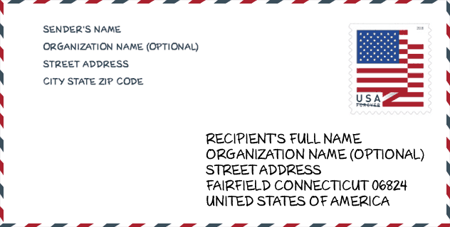
Envelope Example

This is an example of a US zip envelope. You can use a 5-digit zipcode or a detailed 9-digit zipcode to copy the mail in the following address format.
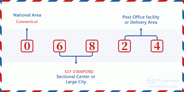
06824 Basic Meaning
What does each digit of ZIP Code 06824 stands for? The first digit designates a national area, which ranges from zero for the Northeast to nine for the far West. The 2-3 digits are the code of a sectional center facility in that region. The last two digits designate small post offices or postal zones.
Online Map

This is online map of the address Fairfield, Connecticut, United States. You may use button to move and zoom in / out. The map information is for reference only.
Museum

This is the ZIP Code 06824 - Museum page list. Its detail Museum Name, Street, City, State, ZIP Code, Phone is as below.
| Name | Street | City | State | ZIP Code | Phone |
| FAIRFIELD MUSEUM AND HISTORY CENTER | 370 BEACH ROAD | FAIRFIELD | CT | 06824 | (203) 259-1598 |
| BIRDCRAFT MUSEUM AT FAIRFIELD | 2325 BURR STREET | FAIRFIELD | CT | 06824 | (203) 259-0416 |
| BELLARMINE MUSEUM OF ART | 1073 NORTH BENSON RD | FAIRFIELD | CT | 06824 | (203) 254-4000 |
| METROPOLITAN MUSEUM OF ART PLASTER CAST COLLECTION | 4400 UNIVERSITY DRIVE | FAIRFIELD | CT | 06824 | |
| THOMAS J. WALSH ART GALLERY | 1073 NORTH BENSON ROAD | FAIRFILED | CT | 06824 | (203) 254-4242 |
Library

This is the ZIP Code 06824 - Library page list. Its detail Library Name, Address, City, State, ZIP Code, Phone is as below.
- Name: FAIRFIELD PUBLIC LIBRARY
- Address: 1080 OLD POST RD.
- City: FAIRFIELD
- State: CT - Connecticut
- ZIP Code: 06824
- Phone: (203) 256-3155
School

This is the ZIP Code 06824 - School page list. Its detail School Name, Address, City, State, ZIP Code is as below.
| School Name | Address | City | State | Grades | ZIP Code |
|---|---|---|---|---|---|
| Dwight Elementary School | 1600 Redding Rd. | Fairfield | CT | UG | 06824 |
| Fairfield Woods Middle School | 1115 Fairfield Woods Rd. | Fairfield | CT | UG | 06824 |
| Holland Hill School | 105 Meadowcroft Road | Fairfield | CT | UG | 06824 |
| Jennings School | 31 Palm Dr. | Fairfield | CT | UG | 06824 |
| Riverfield School | 1625 Mill Plain Rd. | Fairfield | CT | UG | 06824 |
| Sherman School | 250 Fern St. | Fairfield | CT | UG | 06824 |
| Tomlinson Middle School | 200 Unquowa Rd. | Fairfield | CT | UG | 06824 |
| Osborn Hill School | 760 Stillson Rd. | Fairfield | CT | UG | 06824 |
| Roger Ludlowe Middle School | 689 Unquowa Rd. | Fairfield | CT | UG | 06824 |
| Burr Elementary School | 1960 Burr St. | Fairfield | CT | UG | 06824 |
| Fairfield Ludlowe High School | 785 Unquowa Rd. | Fairfield | CT | UG | 06824 |
Population for ZIP Code 06824

What is the total population in ZIP Code 06824? Below is detail information.
- Population for ZIP Code 06824: 32,710
- 2010 Population: 33,900
The 2020 demographic statistics are in progress. The current population in ZIP code 06824 is 32,710, and the population in 2010 is 33,900.
Gender

In all the statistical population, the male population is 16,123, the female population is 17,777.
- Male Population: 16,123
- Female Population: 17,777
Race

In all the statistical population, the male population is 16,123, the female population is 17,777.
- White Population: 31,997
- Black Population: 599
- Hispanic Population: 1,431
- Asian Population: 1,288
- Hawaiian Population: 12
- Indian Population: 86
- Other Population: 392
Age

In all the statistical population, the White population is 31,997, the Black population is 599, the Hispanic population is 1,431, the Asian population is 1,288, the Hawaiian population is 12, the Indian Ppopulation is 86 and Other population is 392.
- Age's Median: 39.0
- Median of male age: 38.1
- Median of female age: 39.8
Households for ZIP Code 06824
ZIP code 06824 has 11,418 households, with an average number of 2.73 persons per household. The average income per household in Zip code 06824 is 144,360 USD, and the average house value is 680,000 USD.
- Households Per Zipcode: 11,418
- Persons Per Household: 2.73
- Average House Value: 680,000
- Income Per Household: 144,360
Geographic

The latitude of the Zip code 06824 is 41.174510, the longitude is -73.284305, and the elevation is 173. It has land area of 20.134 square miles, and water area of 1.292 square miles. The time zone for ZIP code 06824 is Eastern (GMT -05:00). Daylight saving time should be observed in the area where the zip code is located.
- Latitude: 41.174510
- Longitude: -73.284305
- Elevation: 173
- Land Area: 20.134
- Water Area: 1.292
- Time Zone: Eastern (GMT -05:00)
- Region: Northeast
- Division: New England
- Day Light Saving: Y
Congressional District

The Congressional District for ZIP code 06824 is Connecticut's 04th congressional district, the Congressional Land Area is 460.73 square mile.
- Congressional District: 04th
- Congressional Land Area: 460.73
Delivery

In the ZIP code 06824, there are 11,982 residential delivery mailboxes and centralized units, and 1,093 commercial delivery mailbox and centralized units, 11,378 single family deliveries and 208 multifamily deliveries, and the box count is 13,539. The main post office has city delivery carrier routes for the ZIP code 06824.
- Delivery Residential: 11,982
- Delivery Business: 1,093
- Delivery Total: 13,539
- Single Family Delivery Units: 11,378
- Multi Family Delivery Units: 208
- City Delivery Indicator: Y
Business

In ZIP code 06824, the number of business is 1,076, the number of employee is 13,526, the business first quarter payroll is 166,849,000 USD, the business annual payroll is 688,422,000 USD.
- Number Of Businesses: 1,076
- Number Of Employees: 13,526
- Business First Quarter Payroll: 166,849,000
- Business Annual Payroll: 688,422,000


Add new comment