ZIP Code: 06902, Stamford, CT
ZIP Code 06902 is located in Stamford, Connecticut. Its detail State, County, City, Longitude, Latitude, Envelope Example, Population is as below.
ZIP Code 06902 Information

-
-
Country:
U.S. - United States
State:
County FIPS:
09001
City:
City Type ?In many cases, a ZIP Code can have multiple "names", meaning cities, towns, or subdivisions, in its boundaries. However, it will ALWAYS have exactly 1 "default" name. D - Default - This is the "preferred" name - by the USPS - for a city. Each ZIP Code has one - and only one - "default" name. In most cases, this is what people who live in that area call the city as well. A - Acceptable - This name can be used for mailing purposes. Often times alternative names are large neighborhoods or sections of the city/town. In some cases a ZIP Code may have several "acceptable" names which is used to group towns under one ZIP Code. N - Not Acceptable - A "not acceptable" name is, in many cases, a nickname that residents give that location. According to the USPS, you should NOT send mail to that ZIP Code using the "not acceptable" name when mailing.:
D (Default)
ZIP Code:
06902
❓What does D (Default) mean? This is the "preferred" name - by the USPS - for a city. Each ZIP Code has one - and only one - "default" name. In most cases, this is what people who live in that area call the city as well.
ZIP Code 06902 Plus 4
ZIP Code 5 plus 4 is the extension of 5-digit zip code, It can be used to locate a more detailed location. The last four digits designate segment or one side of a street or an apartment. You can find the ZIP+4 code and corresponding address of the zip code 06902 below.
| ZIP Code 5 Plus 4 | Address |
|---|---|
| 06902-0001 | 1 BLACHLEY RD, STAMFORD, CT |
| 06902-0101 | PO BOX 200001, STAMFORD, CT |
| 06902-1000 | 103 BROOKHOLLOW LN, STAMFORD, CT |
| 06902-1001 | 1 ELJAYS LN, STAMFORD, CT |
| 06902-1002 | 1 HIGHLINE TRL, STAMFORD, CT |
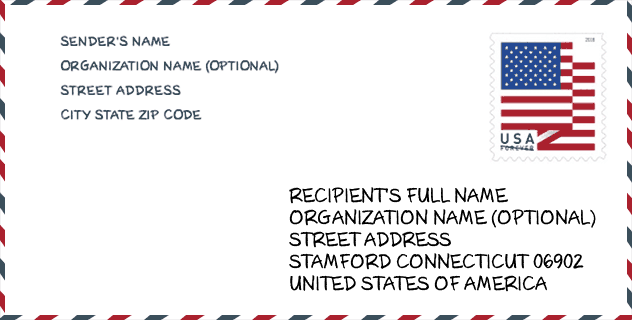
Envelope Example

This is an example of a US zip envelope. You can use a 5-digit zipcode or a detailed 9-digit zipcode to copy the mail in the following address format.
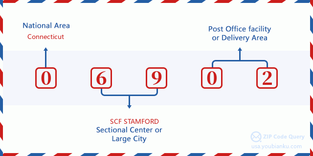
06902 Basic Meaning
What does each digit of ZIP Code 06902 stands for? The first digit designates a national area, which ranges from zero for the Northeast to nine for the far West. The 2-3 digits are the code of a sectional center facility in that region. The last two digits designate small post offices or postal zones.
Online Map

This is online map of the address Stamford, Connecticut, United States. You may use button to move and zoom in / out. The map information is for reference only.
Museum

This is the ZIP Code 06902 - Museum page list. Its detail Museum Name, Street, City, State, ZIP Code, Phone is as below.
- Name: OPERATION SAIL
- Street: 500 WEST AVE
- City: STAMFORD
- State: CT
- ZIP Code: 06902
- Phone: (212) 422-2162
Library

This is the ZIP Code 06902 - Library page list. Its detail Library Name, Address, City, State, ZIP Code, Phone is as below.
- Name: SOUTH END COMMUNITY CENTER BRANCH LIBRARY
- Address: 34 WOODLAND ST
- City: STAMFORD
- State: CT - Connecticut
- ZIP Code: 06902
- Phone: (203) 964-1000
School

This is the ZIP Code 06902 - School page list. Its detail School Name, Address, City, State, ZIP Code is as below.
| School Name | Address | City | State | Grades | ZIP Code |
|---|---|---|---|---|---|
| Stamford Charter School for Excellence | 1 Schuyler Ave. | Stamford | CT | UG | 06902 |
| Hart School | 61 Adams Ave. | Stamford | CT | UG | 06902 |
| Rogers International School | 202 Blachley Road | Stamford | CT | UG | 06902 |
| Stamford High School | 55 Strawberry Hill Ave. | Stamford | CT | UG | 06902 |
| Stillmeadow School | 800 Stillwater Rd. | Stamford | CT | UG | 06902 |
| Westhill High School | 125 Roxbury Rd. | Stamford | CT | UG | 06902 |
| Westover School | 412 Stillwater Ave. | Stamford | CT | UG | 06902 |
| Strawberry Hill an ext. of Rogers International | 200 Strawberry Hill Ave. | Stamford | CT | UG | 06902 |
Population for ZIP Code 06902

What is the total population in ZIP Code 06902? Below is detail information.
- Population for ZIP Code 06902: 70,224
- 2010 Population: 63,406
The 2020 demographic statistics are in progress. The current population in ZIP code 06902 is 70,224, and the population in 2010 is 63,406.
Gender

In all the statistical population, the male population is 31,676, the female population is 31,730.
- Male Population: 31,676
- Female Population: 31,730
Race

In all the statistical population, the male population is 31,676, the female population is 31,730.
- White Population: 36,018
- Black Population: 13,482
- Hispanic Population: 21,823
- Asian Population: 4,699
- Hawaiian Population: 157
- Indian Population: 601
- Other Population: 11,043
Age

In all the statistical population, the White population is 36,018, the Black population is 13,482, the Hispanic population is 21,823, the Asian population is 4,699, the Hawaiian population is 157, the Indian Ppopulation is 601 and Other population is 11,043.
- Age's Median: 34.9
- Median of male age: 33.3
- Median of female age: 36.8
Households for ZIP Code 06902
ZIP code 06902 has 23,502 households, with an average number of 2.66 persons per household. The average income per household in Zip code 06902 is 72,961 USD, and the average house value is 413,400 USD.
- Households Per Zipcode: 23,502
- Persons Per Household: 2.66
- Average House Value: 413,400
- Income Per Household: 72,961
Geographic

The latitude of the Zip code 06902 is 41.060298, the longitude is -73.545275, and the elevation is 20. It has land area of 10.173 square miles, and water area of 2.367 square miles. The time zone for ZIP code 06902 is Eastern (GMT -05:00). Daylight saving time should be observed in the area where the zip code is located.
- Latitude: 41.060298
- Longitude: -73.545275
- Elevation: 20
- Land Area: 10.173
- Water Area: 2.367
- Time Zone: Eastern (GMT -05:00)
- Region: Northeast
- Division: New England
- Day Light Saving: Y
Congressional District

The Congressional District for ZIP code 06902 is Connecticut's 04th congressional district, the Congressional Land Area is 460.73 square mile.
- Congressional District: 04th
- Congressional Land Area: 460.73
Delivery

In the ZIP code 06902, there are 26,400 residential delivery mailboxes and centralized units, and 1,789 commercial delivery mailbox and centralized units, 13,256 single family deliveries and 10,141 multifamily deliveries, and the box count is 28,524. The main post office has city delivery carrier routes for the ZIP code 06902.
- Delivery Residential: 26,400
- Delivery Business: 1,789
- Delivery Total: 28,524
- Single Family Delivery Units: 13,256
- Multi Family Delivery Units: 10,141
- City Delivery Indicator: Y
Business

In ZIP code 06902, the number of business is 1,782, the number of employee is 37,598, the business first quarter payroll is 1,332,919,000 USD, the business annual payroll is 4,501,940,000 USD.
- Number Of Businesses: 1,782
- Number Of Employees: 37,598
- Business First Quarter Payroll: 1,332,919,000
- Business Annual Payroll: 4,501,940,000


Add new comment