ZIP Code: 19460, Phoenixville, PA
ZIP Code 19460 is located in Phoenixville, Pennsylvania. Its detail State, County, City, Longitude, Latitude, Envelope Example, Population is as below.

ZIP Code 19460 Information

-
-
Country:
U.S. - United States
State:
County FIPS:
42029
County:
City:
City Type ?In many cases, a ZIP Code can have multiple "names", meaning cities, towns, or subdivisions, in its boundaries. However, it will ALWAYS have exactly 1 "default" name. D - Default - This is the "preferred" name - by the USPS - for a city. Each ZIP Code has one - and only one - "default" name. In most cases, this is what people who live in that area call the city as well. A - Acceptable - This name can be used for mailing purposes. Often times alternative names are large neighborhoods or sections of the city/town. In some cases a ZIP Code may have several "acceptable" names which is used to group towns under one ZIP Code. N - Not Acceptable - A "not acceptable" name is, in many cases, a nickname that residents give that location. According to the USPS, you should NOT send mail to that ZIP Code using the "not acceptable" name when mailing.:
D (Default)
ZIP Code:
19460
❓What does D (Default) mean? This is the "preferred" name - by the USPS - for a city. Each ZIP Code has one - and only one - "default" name. In most cases, this is what people who live in that area call the city as well.
ZIP Code 19460 Plus 4
ZIP Code 5 plus 4 is the extension of 5-digit zip code, It can be used to locate a more detailed location. The last four digits designate segment or one side of a street or an apartment. You can find the ZIP+4 code and corresponding address of the zip code 19460 below.
| ZIP Code 5 Plus 4 | Address |
|---|---|
| 19460-0001 | PO BOX 1, PHOENIXVILLE, PA |
| 19460-0007 | PO BOX 1001, PHOENIXVILLE, PA |
| 19460-0011 | PO BOX 11, PHOENIXVILLE, PA |
| 19460-0017 | PO BOX 1005, PHOENIXVILLE, PA |
| 19460-0021 | PO BOX 21, PHOENIXVILLE, PA |
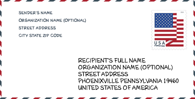
Envelope Example

This is an example of a US zip envelope. You can use a 5-digit zipcode or a detailed 9-digit zipcode to copy the mail in the following address format.
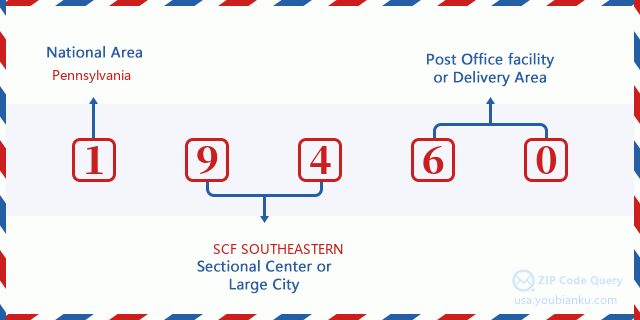
19460 Basic Meaning
What does each digit of ZIP Code 19460 stands for? The first digit designates a national area, which ranges from zero for the Northeast to nine for the far West. The 2-3 digits are the code of a sectional center facility in that region. The last two digits designate small post offices or postal zones.
Online Map

This is online map of the address Phoenixville, Pennsylvania, United States. You may use button to move and zoom in / out. The map information is for reference only.
Hospital

This is the ZIP Code 19460 - Hospital page list. Its detail Hospital Name, Street, City, State, ZIP Code, Phone is as below.
- Name: PHOENIXVILLE HOSPITAL
- Address: PHOENIXVILLE
- City: 140 NUTT ROAD
- State: PA
- ZIP Code: 19460
- Phone: (610) 983-1000
Library

This is the ZIP Code 19460 - Library page list. Its detail Library Name, Address, City, State, ZIP Code, Phone is as below.
- Name: PHOENIXVILLE PUBLIC LIBRARY
- Address: 183 SECOND AVE
- City: PHOENIXVILLE
- State: PA - Pennsylvania
- ZIP Code: 19460
- Phone: (610) 933-3013
School

This is the ZIP Code 19460 - School page list. Its detail School Name, Address, City, State, ZIP Code is as below.
| School Name | Address | City | State | Grades | ZIP Code |
|---|---|---|---|---|---|
| Renaissance Academy CS | 413 Fairview Street | Phoenixville | PA | UG | 19460 |
| Phoenixville Area HS | 1200 Gay St | Phoenixville | PA | UG | 19460 |
| Manavon El Sch | 2 Phantom Way | Phoenixville | PA | UG | 19460 |
| Phoenixville Early Learning Ctr | 1 Phantom Way | Phoenixville | PA | UG | 19460 |
Population for ZIP Code 19460

What is the total population in ZIP Code 19460? Below is detail information.
- Population for ZIP Code 19460: 44,306
- 2010 Population: 40,154
The 2020 demographic statistics are in progress. The current population in ZIP code 19460 is 44,306, and the population in 2010 is 40,154.
Gender

In all the statistical population, the male population is 19,763, the female population is 20,391.
- Male Population: 19,763
- Female Population: 20,391
Race

In all the statistical population, the male population is 19,763, the female population is 20,391.
- White Population: 35,496
- Black Population: 2,384
- Hispanic Population: 1,775
- Asian Population: 2,098
- Hawaiian Population: 54
- Indian Population: 187
- Other Population: 758
Age

In all the statistical population, the White population is 35,496, the Black population is 2,384, the Hispanic population is 1,775, the Asian population is 2,098, the Hawaiian population is 54, the Indian Ppopulation is 187 and Other population is 758.
- Age's Median: 39.0
- Median of male age: 37.8
- Median of female age: 39.9
Households for ZIP Code 19460
ZIP code 19460 has 15,852 households, with an average number of 2.47 persons per household. The average income per household in Zip code 19460 is 96,997 USD, and the average house value is 303,500 USD.
- Households Per Zipcode: 15,852
- Persons Per Household: 2.47
- Average House Value: 303,500
- Income Per Household: 96,997
Geographic

The latitude of the Zip code 19460 is 40.130330, the longitude is -75.521458, and the elevation is 117. It has land area of 35.352 square miles, and water area of 1.243 square miles. The time zone for ZIP code 19460 is Eastern (GMT -05:00). Daylight saving time should be observed in the area where the zip code is located.
- Latitude: 40.130330
- Longitude: -75.521458
- Elevation: 117
- Land Area: 35.352
- Water Area: 1.243
- Time Zone: Eastern (GMT -05:00)
- Region: Northeast
- Division: Middle Atlantic
- Day Light Saving: Y
Congressional District

The Congressional District for ZIP code 19460 is Pennsylvania's 04th congressional district, the Congressional Land Area is 1517.84 square mile.
- Congressional District: 04th
- Congressional Land Area: 1517.84
Delivery

In the ZIP code 19460, there are 17,938 residential delivery mailboxes and centralized units, and 967 commercial delivery mailbox and centralized units, 12,539 single family deliveries and 1,148 multifamily deliveries, and the box count is 18,969. The main post office has city delivery carrier routes for the ZIP code 19460.
- Delivery Residential: 17,938
- Delivery Business: 967
- Delivery Total: 18,969
- Single Family Delivery Units: 12,539
- Multi Family Delivery Units: 1,148
- City Delivery Indicator: Y
Business

In ZIP code 19460, the number of business is 970, the number of employee is 11,150, the business first quarter payroll is 121,636,000 USD, the business annual payroll is 506,763,000 USD.
- Number Of Businesses: 970
- Number Of Employees: 11,150
- Business First Quarter Payroll: 121,636,000
- Business Annual Payroll: 506,763,000
Social Security Benefits

There are 6,975 beneficiaries with benefits in current-payment status for ZIP code 19460, of which 5,210 are retired workers, 705 are disabled workers, 390 are widow(er)s and parents, 325 are spouses and 345 are children. The number of beneficiaries aged 65 or older is 5,740. The total monthly benefits are 11,611,000 USD, of which 9,306,000 USD for retired workers, 660,000 USD for widow(er)s and parents.
- Total Number: 6,975
- Retired workers Number: 5,210
- Disabled workers Number: 705
- Widow(er)s and parents Number: 390
- Spouses Number: 325
- Children Number: 345
- All beneficiaries per month: 11,611,000
- Retired workers per month: 9,306,000
- Widow(er)s and parents per month: 660,000
- Number of beneficiaries aged 65 or older: 5,740


Add new comment