United States ZIP Code: 21214
This is the Maryland ZIP Code 21214 page list. Its detail State, County, City, Longitude, Latitude, Envelope Example, Population is as below.

ZIP Code 21214 Information

-
-
Country:
U.S. - United States
State:
State FIPS:
24
ZIP Code:
21214
ZIP Type:
S (Standard)
❓What does S (Standard) mean? A "standard" ZIP Code is what most people think of when they talk about ZIP Codes - essentially a town, city, or a division of a city that has mail service.
ZIP Code 21214 - City

This is the city information corresponding to 21214:
| State | County | City | City Type ?In many cases, a ZIP Code can have multiple "names", meaning cities, towns, or subdivisions, in its boundaries. However, it will ALWAYS have exactly 1 "default" name. D - Default - This is the "preferred" name - by the USPS - for a city. Each ZIP Code has one - and only one - "default" name. In most cases, this is what people who live in that area call the city as well. A - Acceptable - This name can be used for mailing purposes. Often times alternative names are large neighborhoods or sections of the city/town. In some cases a ZIP Code may have several "acceptable" names which is used to group towns under one ZIP Code. N - Not Acceptable - A "not acceptable" name is, in many cases, a nickname that residents give that location. According to the USPS, you should NOT send mail to that ZIP Code using the "not acceptable" name when mailing. | ZIP Code |
|---|---|---|---|---|
| MD | Baltimore City | Baltimore | D (Default) | 21214 |
| MD | Baltimore City | Hamilton | N (Not Acceptable) | 21214 |
❓What does D (Default) mean? This is the "preferred" name - by the USPS - for a city. Each ZIP Code has one - and only one - "default" name. In most cases, this is what people who live in that area call the city as well.
❓What does N (Not Acceptable) mean? A "not acceptable" name is, in many cases, a nickname that residents give that location. According to the USPS, you should NOT send mail to that ZIP Code using the "not acceptable" name when mailing.
ZIP Code 21214 Plus 4
ZIP Code 5 plus 4 is the extension of 5-digit zip code, It can be used to locate a more detailed location. The last four digits designate segment or one side of a street or an apartment. You can find the ZIP+4 code and corresponding address of the zip code 21214 below.
| ZIP Code 5 Plus 4 | Address |
|---|---|
| 21214-0300 | PO BOX 24600, BALTIMORE, MD |
| 21214-0310 | PO BOX 24610, BALTIMORE, MD |
| 21214-0311 | PO BOX 24611, BALTIMORE, MD |
| 21214-0340 | PO BOX 24640, BALTIMORE, MD |
| 21214-0341 | PO BOX 24641, BALTIMORE, MD |
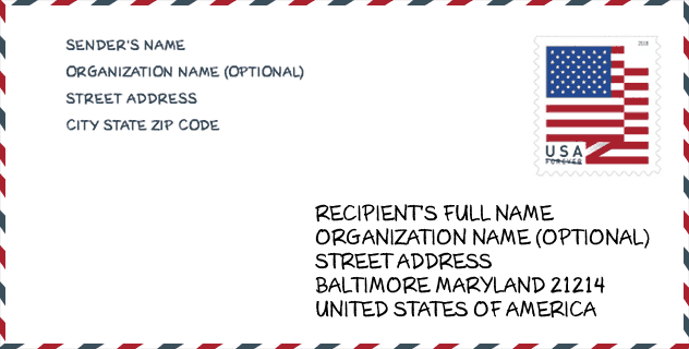
Envelope Example

This is an example of a US zip envelope. You can use a 5-digit zipcode or a detailed 9-digit zipcode to copy the mail in the following address format.
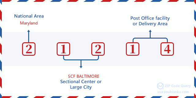
21214 Basic Meaning
What does each digit of ZIP Code 21214 stands for? The first digit designates a national area, which ranges from zero for the Northeast to nine for the far West. The 2-3 digits are the code of a sectional center facility in that region. The last two digits designate small post offices or postal zones.
Online Map

This is online map of the address Hamilton, Maryland, United States. You may use button to move and zoom in / out. The map information is for reference only.
Library

This is the ZIP Code 21214 - Library page list. Its detail Library Name, Address, City, State, ZIP Code, Phone is as below.
- Name: HAMILTON BRANCH
- Address: 5910 HARFORD RD.
- City: BALTIMORE
- State: MD - Maryland
- ZIP Code: 21214
- Phone: (410) 396-6088
School

This is the ZIP Code 21214 - School page list. Its detail School Name, Address, City, State, ZIP Code is as below.
| School Name | Address | City | State | Grades | ZIP Code |
|---|---|---|---|---|---|
| Hamilton Elementary/Middle | 6101 Old Harford Road | Baltimore | MD | UG | 21214 |
| Achievement Academy at Harbor City High | 2201 Pinewood Avenue | Baltimore | MD | UG | 21214 |
| Montebello Elementary/Middle | 2500 E NORTHERN PARKWAY | Baltimore | MD | UG | 21214 |
| Reginald F. Lewis High | 6401 Pioneer Drive | Baltimore | MD | UG | 21214 |
| City Neighbors Hamilton | 5609 Sefton Avenue | Baltimore | MD | UG | 21214 |
| City Neighbors High | 5609 Sefton Avenue | Baltimore | MD | UG | 21214 |
| Baltimore International Academy West | 4300 Sidehill Road | Baltimore | MD | UG | 21214 |
Population for ZIP Code 21214

What is the total population in ZIP Code 21214? Below is detail information.
- Population for ZIP Code 21214: 19,567
- 2010 Population: 20,564
The 2020 demographic statistics are in progress. The current population in ZIP code 21214 is 19,567, and the population in 2010 is 20,564.
Gender

In all the statistical population, the male population is 9,701, the female population is 10,863.
- Male Population: 9,701
- Female Population: 10,863
Race

In all the statistical population, the male population is 9,701, the female population is 10,863.
- White Population: 8,880
- Black Population: 11,416
- Hispanic Population: 520
- Asian Population: 386
- Hawaiian Population: 27
- Indian Population: 206
- Other Population: 259
Age

In all the statistical population, the White population is 8,880, the Black population is 11,416, the Hispanic population is 520, the Asian population is 386, the Hawaiian population is 27, the Indian Ppopulation is 206 and Other population is 259.
- Age's Median: 39.0
- Median of male age: 38.4
- Median of female age: 39.4
Households for ZIP Code 21214
ZIP code 21214 has 8,163 households, with an average number of 2.50 persons per household. The average income per household in Zip code 21214 is 68,554 USD, and the average house value is 180,300 USD.
- Households Per Zipcode: 8,163
- Persons Per Household: 2.50
- Average House Value: 180,300
- Income Per Household: 68,554
Geographic

The latitude of the Zip code 21214 is 39.350375, the longitude is -76.562924, and the elevation is 297. It has land area of 2.854 square miles, and water area of 0 square miles. The time zone for ZIP code 21214 is Eastern (GMT -05:00). Daylight saving time should be observed in the area where the zip code is located.
- Latitude: 39.350375
- Longitude: -76.562924
- Elevation: 297
- Land Area: 2.854
- Water Area: 0
- Time Zone: Eastern (GMT -05:00)
- Region: South
- Division: South Atlantic
- Day Light Saving: Y
Congressional District

The Congressional District for ZIP code 21214 is Maryland's 2nd|3rd|07th congressional district, the Congressional Land Area is 348.88|304.14|488.03 square mile.
- Congressional District: 2nd|3rd|07th
- Congressional Land Area: 348.88|304.14|488.03
Delivery

In the ZIP code 21214, there are 7,827 residential delivery mailboxes and centralized units, and 383 commercial delivery mailbox and centralized units, 7,570 single family deliveries and 179 multifamily deliveries, and the box count is 8,754. The main post office has city delivery carrier routes for the ZIP code 21214.
- Delivery Residential: 7,827
- Delivery Business: 383
- Delivery Total: 8,754
- Single Family Delivery Units: 7,570
- Multi Family Delivery Units: 179
- City Delivery Indicator: Y
Business

In ZIP code 21214, the number of business is 292, the number of employee is 2,656, the business first quarter payroll is 18,024,000 USD, the business annual payroll is 79,150,000 USD.
- Number Of Businesses: 292
- Number Of Employees: 2,656
- Business First Quarter Payroll: 18,024,000
- Business Annual Payroll: 79,150,000
Social Security Benefits

There are 3,535 beneficiaries with benefits in current-payment status for ZIP code 21214, of which 2,400 are retired workers, 625 are disabled workers, 190 are widow(er)s and parents, 65 are spouses and 255 are children. The number of beneficiaries aged 65 or older is 2,530. The total monthly benefits are 5,000,000 USD, of which 3,731,000 USD for retired workers, 271,000 USD for widow(er)s and parents.
- Total Number: 3,535
- Retired workers Number: 2,400
- Disabled workers Number: 625
- Widow(er)s and parents Number: 190
- Spouses Number: 65
- Children Number: 255
- All beneficiaries per month: 5,000,000
- Retired workers per month: 3,731,000
- Widow(er)s and parents per month: 271,000
- Number of beneficiaries aged 65 or older: 2,530


Add new comment