United States ZIP Code: 21297
This is the Maryland ZIP Code 21297 page list. Its detail State, County, City, Longitude, Latitude, Envelope Example, Population is as below.

ZIP Code 21297 Information

-
-
Country:
U.S. - United States
State:
State FIPS:
24
ZIP Code:
21297
ZIP Type:
P (PO Box Only)
❓What does P (PO Box Only) mean? Rural towns, groups of towns, or even high-growth areas of cities are given a "PO Box Only" ZIP Code type.
ZIP Code 21297 - City

This is the city information corresponding to 21297:
| State | County | City | City Type ?In many cases, a ZIP Code can have multiple "names", meaning cities, towns, or subdivisions, in its boundaries. However, it will ALWAYS have exactly 1 "default" name. D - Default - This is the "preferred" name - by the USPS - for a city. Each ZIP Code has one - and only one - "default" name. In most cases, this is what people who live in that area call the city as well. A - Acceptable - This name can be used for mailing purposes. Often times alternative names are large neighborhoods or sections of the city/town. In some cases a ZIP Code may have several "acceptable" names which is used to group towns under one ZIP Code. N - Not Acceptable - A "not acceptable" name is, in many cases, a nickname that residents give that location. According to the USPS, you should NOT send mail to that ZIP Code using the "not acceptable" name when mailing. | ZIP Code |
|---|---|---|---|---|
| MD | Baltimore City | Baltimore | D (Default) | 21297 |
| MD | Baltimore City | Firms-courtesy Reply | N (Not Acceptable) | 21297 |
❓What does D (Default) mean? This is the "preferred" name - by the USPS - for a city. Each ZIP Code has one - and only one - "default" name. In most cases, this is what people who live in that area call the city as well.
❓What does N (Not Acceptable) mean? A "not acceptable" name is, in many cases, a nickname that residents give that location. According to the USPS, you should NOT send mail to that ZIP Code using the "not acceptable" name when mailing.
ZIP Code 21297 Plus 4
ZIP Code 5 plus 4 is the extension of 5-digit zip code, It can be used to locate a more detailed location. The last four digits designate segment or one side of a street or an apartment. You can find the ZIP+4 code and corresponding address of the zip code 21297 below.
| ZIP Code 5 Plus 4 | Address |
|---|---|
| 21297-0108 | PO BOX 17388, BALTIMORE, MD |
| 21297-0127 | PO BOX 17312, BALTIMORE, MD |
| 21297-0135 | PO BOX 17081, BALTIMORE, MD |
| 21297-0137 | PO BOX 17311, BALTIMORE, MD |
| 21297-0150 | PO BOX 17363, BALTIMORE, MD |
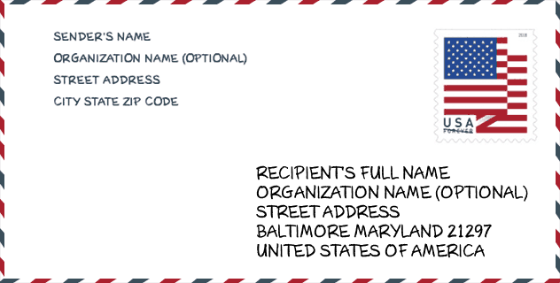
Envelope Example

This is an example of a US zip envelope. You can use a 5-digit zipcode or a detailed 9-digit zipcode to copy the mail in the following address format.
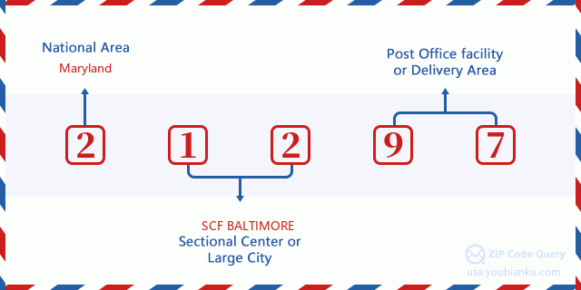
21297 Basic Meaning
What does each digit of ZIP Code 21297 stands for? The first digit designates a national area, which ranges from zero for the Northeast to nine for the far West. The 2-3 digits are the code of a sectional center facility in that region. The last two digits designate small post offices or postal zones.
Online Map

This is online map of the address Firms-courtesy Reply, Maryland, United States. You may use button to move and zoom in / out. The map information is for reference only.
Geographic

The latitude of the Zip code 21297 is 39.290500, the longitude is -76.612500, and the elevation is 37. It has land area of 0 square miles, and water area of 0 square miles. The time zone for ZIP code 21297 is Eastern (GMT -05:00). Daylight saving time should be observed in the area where the zip code is located.
- Latitude: 39.290500
- Longitude: -76.612500
- Elevation: 37
- Land Area: 0
- Water Area: 0
- Time Zone: Eastern (GMT -05:00)
- Region: South
- Division: South Atlantic
- Day Light Saving: Y
Congressional District

The Congressional District for ZIP code 21297 is Maryland's 07th congressional district, the Congressional Land Area is 488.03 square mile.
- Congressional District: 07th
- Congressional Land Area: 488.03
Delivery

In the ZIP code 21297, there are 0 residential delivery mailboxes and centralized units, and 0 commercial delivery mailbox and centralized units, 0 single family deliveries and 0 multifamily deliveries, and the box count is 232. The main post office has city delivery carrier routes for the ZIP code 21297.
- Delivery Residential: 0
- Delivery Business: 0
- Delivery Total: 232
- Single Family Delivery Units: 0
- Multi Family Delivery Units: 0
- City Delivery Indicator: Y


Add new comment