United States ZIP Code: 26505
This is the West Virginia ZIP Code 26505 page list. Its detail State, County, City, Longitude, Latitude, Envelope Example, Population is as below.
ZIP Code 26505 Information

-
-
Country:
U.S. - United States
State:
State FIPS:
54
ZIP Code:
26505
ZIP Type:
S (Standard)
❓What does S (Standard) mean? A "standard" ZIP Code is what most people think of when they talk about ZIP Codes - essentially a town, city, or a division of a city that has mail service.
-


-
Iconic US Landmark Legacy Designs
Get PNG, SVG, EPS, AI, PDF Versions at Just $0.1
 Download Now
-


ZipCodeCraft
ZIP Code 26505 - City

This is the city information corresponding to 26505:
| State | County | City | City Type ?In many cases, a ZIP Code can have multiple "names", meaning cities, towns, or subdivisions, in its boundaries. However, it will ALWAYS have exactly 1 "default" name. D - Default - This is the "preferred" name - by the USPS - for a city. Each ZIP Code has one - and only one - "default" name. In most cases, this is what people who live in that area call the city as well. A - Acceptable - This name can be used for mailing purposes. Often times alternative names are large neighborhoods or sections of the city/town. In some cases a ZIP Code may have several "acceptable" names which is used to group towns under one ZIP Code. N - Not Acceptable - A "not acceptable" name is, in many cases, a nickname that residents give that location. According to the USPS, you should NOT send mail to that ZIP Code using the "not acceptable" name when mailing. | ZIP Code |
|---|---|---|---|---|
| WV | Monongalia | Booth | A (Acceptable) | 26505 |
| WV | Monongalia | Everettville | A (Acceptable) | 26505 |
| WV | Monongalia | Morgantown | D (Default) | 26505 |
| WV | Monongalia | Sabraton | N (Not Acceptable) | 26505 |
| WV | Monongalia | Star City | A (Acceptable) | 26505 |
❓What does D (Default) mean? This is the "preferred" name - by the USPS - for a city. Each ZIP Code has one - and only one - "default" name. In most cases, this is what people who live in that area call the city as well.
❓What does A (Acceptable) mean? This name can be used for mailing purposes. Often times alternative names are large neighborhoods or sections of the city/town. In some cases a ZIP Code may have several "acceptable" names which is used to group towns under one ZIP Code.
❓What does N (Not Acceptable) mean? A "not acceptable" name is, in many cases, a nickname that residents give that location. According to the USPS, you should NOT send mail to that ZIP Code using the "not acceptable" name when mailing.
ZIP Code 26505 Plus 4
ZIP Code 5 plus 4 is the extension of 5-digit zip code, It can be used to locate a more detailed location. The last four digits designate segment or one side of a street or an apartment. You can find the ZIP+4 code and corresponding address of the zip code 26505 below.
| ZIP Code 5 Plus 4 | Address |
|---|---|
| 26505-0200 | 6200 UNIVERSITY COMMONS DR, MORGANTOWN, WV |
| 26505-0201 | 6100 UNIVERSITY COMMONS DR, MORGANTOWN, WV |
| 26505-0202 | 5300 UNIVERSITY COMMONS DR, MORGANTOWN, WV |
| 26505-0203 | 5200 UNIVERSITY COMMONS DR, MORGANTOWN, WV |
| 26505-0204 | 5100 UNIVERSITY COMMONS DR, MORGANTOWN, WV |
Envelope Example

This is an example of a US zip envelope. You can use a 5-digit zipcode or a detailed 9-digit zipcode to copy the mail in the following address format.

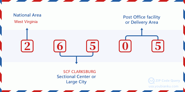
26505 Basic Meaning
What does each digit of ZIP Code 26505 stands for? The first digit designates a national area, which ranges from zero for the Northeast to nine for the far West. The 2-3 digits are the code of a sectional center facility in that region. The last two digits designate small post offices or postal zones.
Online Map

This is online map of the address Star City, West Virginia, United States. You may use button to move and zoom in / out. The map information is for reference only.
University

This is the ZIP Code 26505 - University page list. Its detail university Name, Street, City, State, ZIP Code, Phone is as below.
| Name | Street | City | State | ZIP Code | Phone |
| Ross Medical Education Center-Morgantown | 1474 East L. Core Road | Morgantown | WV | 26505 | (304) 598-3689 |
| West Virginia Junior College-Morgantown | 148 Willey St | Morgantown | WV | 26505 | (304) 296-8282 |
Hospital

This is the ZIP Code 26505 - Hospital page list. Its detail Hospital Name, Street, City, State, ZIP Code, Phone is as below.
- Name: MON HEALTH MEDICAL CENTER
- Address: MORGANTOWN
- City: 1200 JD ANDERSON DRIVE
- State: WV
- ZIP Code: 26505
- Phone: (304) 598-1200
Museum

This is the ZIP Code 26505 - Museum page list. Its detail Museum Name, Street, City, State, ZIP Code, Phone is as below.
| Name | Street | City | State | ZIP Code | Phone |
| MORGAN TOWN GLASS MUSEUM | 1628 MILEGROUND RD | MORGANTOWN | WV | 26505 | (304) 291-2957 |
| CORE ARBORETUM | MONONGAHELA BOULEVARD | MORGANTOWN | WV | 26505 | (304) 293-5201 |
Library

This is the ZIP Code 26505 - Library page list. Its detail Library Name, Address, City, State, ZIP Code, Phone is as below.
- Name: MORGANTOWN PUBLIC LIBRARY
- Address: 373 SPRUCE STREET
- City: MORGANTOWN
- State: WV - West Virginia
- ZIP Code: 26505
- Phone: (304) 291-7425
School
This is the ZIP Code 26505 - School page list. Its detail School Name, Address, City, State, ZIP Code is as below.
| School Name | Address | City | State | Grades | ZIP Code |
|---|---|---|---|---|---|
| MOUNTAINEER MIDDLE SCHOOL | 991 PRICE STREET | MORGANTOWN | WV | UG | 26505 |
| SUNCREST MIDDLE SCHOOL | 360 BALDWIN STREET | MORGANTOWN | WV | UG | 26505 |
| SUNCREST ELEMENTARY SCHOOL | 3647 COLLINS FERRY RD | MORGANTOWN | WV | UG | 26505 |
| NORTH ELEMENTARY SCHOOL | 825 CHESTNUT RIDGE ROAD | MORGANTOWN | WV | UG | 26505 |
| EASTWOOD ELEMENTARY SCHOOL | 677 201ST MEMORIAL HWY | MORGANTOWN | WV | UG | 26505 |
Population for ZIP Code 26505

What is the total population in ZIP Code 26505? Below is detail information.
- Population for ZIP Code 26505: 36,814
- 2010 Population: 38,772
The 2020 demographic statistics are in progress. The current population in ZIP code 26505 is 36,814, and the population in 2010 is 38,772.
Gender

In all the statistical population, the male population is 20,491, the female population is 18,281.
- Male Population: 20,491
- Female Population: 18,281
Race

In all the statistical population, the male population is 20,491, the female population is 18,281.
- White Population: 34,677
- Black Population: 1,975
- Hispanic Population: 896
- Asian Population: 2,422
- Hawaiian Population: 51
- Indian Population: 197
- Other Population: 279
Age

In all the statistical population, the White population is 34,677, the Black population is 1,975, the Hispanic population is 896, the Asian population is 2,422, the Hawaiian population is 51, the Indian Ppopulation is 197 and Other population is 279.
- Age's Median: 23.1
- Median of male age: 22.9
- Median of female age: 23.4
Households for ZIP Code 26505
ZIP code 26505 has 16,422 households, with an average number of 2.00 persons per household. The average income per household in Zip code 26505 is 38,396 USD, and the average house value is 203,700 USD.
- Households Per Zipcode: 16,422
- Persons Per Household: 2.00
- Average House Value: 203,700
- Income Per Household: 38,396
Housing Unit

In ZIP code 26505, the growth rank of housing unit is 100, the number of housing unit was 96,189 in 2010 and increased to 98,528 in 2011, the growth increase number is 2,339, the growth increase percentage is 2.4%.
- Growth Rank: 100
- Housing Units Estimate in 2010: 96,189
- Housing Units Estimate in 2011: 98,528
- Growth Increase Number: 2,339
- Growth Increase Percentage: 2.4%
Geographic

The latitude of the Zip code 26505 is 39.649574, the longitude is -79.945822, and the elevation is 1152. It has land area of 13.132 square miles, and water area of 0.318 square miles. The time zone for ZIP code 26505 is Eastern (GMT -05:00). Daylight saving time should be observed in the area where the zip code is located.
- Latitude: 39.649574
- Longitude: -79.945822
- Elevation: 1152
- Land Area: 13.132
- Water Area: 0.318
- Time Zone: Eastern (GMT -05:00)
- Region: South
- Division: South Atlantic
- Day Light Saving: Y
Congressional District

The Congressional District for ZIP code 26505 is West Virginia's 1st congressional district, the Congressional Land Area is 6275.56 square mile.
- Congressional District: 1st
- Congressional Land Area: 6275.56
Delivery

In the ZIP code 26505, there are 18,407 residential delivery mailboxes and centralized units, and 1,364 commercial delivery mailbox and centralized units, 8,224 single family deliveries and 5,201 multifamily deliveries, and the box count is 19,636. The main post office has city delivery carrier routes for the ZIP code 26505.
- Delivery Residential: 18,407
- Delivery Business: 1,364
- Delivery Total: 19,636
- Single Family Delivery Units: 8,224
- Multi Family Delivery Units: 5,201
- City Delivery Indicator: Y
Business

In ZIP code 26505, the number of business is 1,039, the number of employee is 19,131, the business first quarter payroll is 255,881,000 USD, the business annual payroll is 916,082,000 USD.
- Number Of Businesses: 1,039
- Number Of Employees: 19,131
- Business First Quarter Payroll: 255,881,000
- Business Annual Payroll: 916,082,000
Social Security Benefits

There are 3,530 beneficiaries with benefits in current-payment status for ZIP code 26505, of which 2,565 are retired workers, 345 are disabled workers, 290 are widow(er)s and parents, 160 are spouses and 170 are children. The number of beneficiaries aged 65 or older is 2,900. The total monthly benefits are 5,362,000 USD, of which 4,228,000 USD for retired workers, 431,000 USD for widow(er)s and parents.
- Total Number: 3,530
- Retired workers Number: 2,565
- Disabled workers Number: 345
- Widow(er)s and parents Number: 290
- Spouses Number: 160
- Children Number: 170
- All beneficiaries per month: 5,362,000
- Retired workers per month: 4,228,000
- Widow(er)s and parents per month: 431,000
- Number of beneficiaries aged 65 or older: 2,900


Add new comment