United States ZIP Code: 29170
This is the South Carolina ZIP Code 29170 page list. Its detail State, County, City, Longitude, Latitude, Envelope Example, Population is as below.
ZIP Code 29170 Information

-
-
Country:
U.S. - United States
State:
State FIPS:
45
Area Code:
ZIP Code:
29170
ZIP Type:
S (Standard)
❓What does S (Standard) mean? A "standard" ZIP Code is what most people think of when they talk about ZIP Codes - essentially a town, city, or a division of a city that has mail service.
ZIP Code 29170 - City

This is the city information corresponding to 29170:
| State | County | City | City Type ?In many cases, a ZIP Code can have multiple "names", meaning cities, towns, or subdivisions, in its boundaries. However, it will ALWAYS have exactly 1 "default" name. D - Default - This is the "preferred" name - by the USPS - for a city. Each ZIP Code has one - and only one - "default" name. In most cases, this is what people who live in that area call the city as well. A - Acceptable - This name can be used for mailing purposes. Often times alternative names are large neighborhoods or sections of the city/town. In some cases a ZIP Code may have several "acceptable" names which is used to group towns under one ZIP Code. N - Not Acceptable - A "not acceptable" name is, in many cases, a nickname that residents give that location. According to the USPS, you should NOT send mail to that ZIP Code using the "not acceptable" name when mailing. | ZIP Code |
|---|---|---|---|---|
| SC | Lexington | Cayce | N (Not Acceptable) | 29170 |
| SC | Lexington | West Columbia | D (Default) | 29170 |
❓What does D (Default) mean? This is the "preferred" name - by the USPS - for a city. Each ZIP Code has one - and only one - "default" name. In most cases, this is what people who live in that area call the city as well.
❓What does N (Not Acceptable) mean? A "not acceptable" name is, in many cases, a nickname that residents give that location. According to the USPS, you should NOT send mail to that ZIP Code using the "not acceptable" name when mailing.
ZIP Code 29170 Plus 4
ZIP Code 5 plus 4 is the extension of 5-digit zip code, It can be used to locate a more detailed location. The last four digits designate segment or one side of a street or an apartment. You can find the ZIP+4 code and corresponding address of the zip code 29170 below.
| ZIP Code 5 Plus 4 | Address |
|---|---|
| 29170-1000 | 101 BROKEN ARROW TRL, WEST COLUMBIA, SC |
| 29170-1001 | 100 BROKEN ARROW TRL, WEST COLUMBIA, SC |
| 29170-1001 | 143 BROKEN ARROW TRL, WEST COLUMBIA, SC |
| 29170-1002 | 100 DOGWOOD LN, WEST COLUMBIA, SC |
| 29170-1003 | 101 DACUS LN, WEST COLUMBIA, SC |
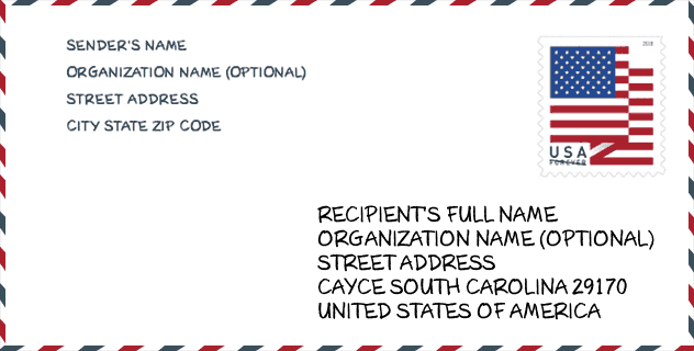
Envelope Example

This is an example of a US zip envelope. You can use a 5-digit zipcode or a detailed 9-digit zipcode to copy the mail in the following address format.
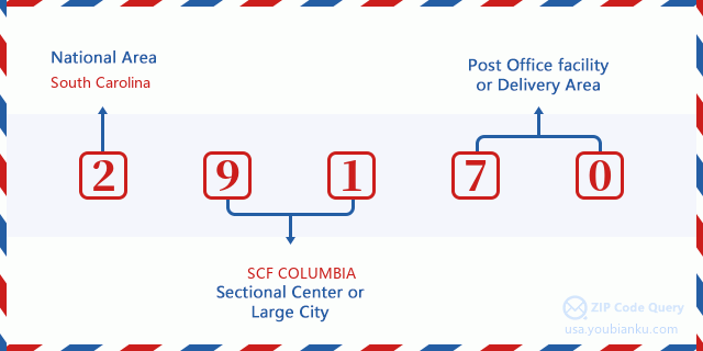
29170 Basic Meaning
What does each digit of ZIP Code 29170 stands for? The first digit designates a national area, which ranges from zero for the Northeast to nine for the far West. The 2-3 digits are the code of a sectional center facility in that region. The last two digits designate small post offices or postal zones.
Online Map

This is online map of the address West Columbia, South Carolina, United States. You may use button to move and zoom in / out. The map information is for reference only.
School

This is the ZIP Code 29170 - School page list. Its detail School Name, Address, City, State, ZIP Code is as below.
| School Name | Address | City | State | Grades | ZIP Code |
|---|---|---|---|---|---|
| White Knoll Middle | 116 White Knoll Way | West Columbia | SC | UG | 29170 |
| White Knoll Elementary | 132 White Knoll Way | West Columbia | SC | UG | 29170 |
| Springdale Elementary | 361 Wattling Road | West Columbia | SC | UG | 29170 |
| Airport High | 1315 Boston Avenue | West Columbia | SC | UG | 29170 |
| R. H. Fulmer Middle | 1614 Walterboro St. | West Columbia | SC | UG | 29170 |
| Midlands Middle College | 1260 Lexington Drive | West Columbia | SC | UG | 29170 |
Population for ZIP Code 29170

What is the total population in ZIP Code 29170? Below is detail information.
- Population for ZIP Code 29170: 23,867
- 2010 Population: 19,988
The 2020 demographic statistics are in progress. The current population in ZIP code 29170 is 23,867, and the population in 2010 is 19,988.
Gender

In all the statistical population, the male population is 9,746, the female population is 10,242.
- Male Population: 9,746
- Female Population: 10,242
Race

In all the statistical population, the male population is 9,746, the female population is 10,242.
- White Population: 16,588
- Black Population: 2,696
- Hispanic Population: 985
- Asian Population: 362
- Hawaiian Population: 27
- Indian Population: 209
- Other Population: 531
Age

In all the statistical population, the White population is 16,588, the Black population is 2,696, the Hispanic population is 985, the Asian population is 362, the Hawaiian population is 27, the Indian Ppopulation is 209 and Other population is 531.
- Age's Median: 37.7
- Median of male age: 36.5
- Median of female age: 38.9
Households for ZIP Code 29170
ZIP code 29170 has 7,924 households, with an average number of 2.51 persons per household. The average income per household in Zip code 29170 is 58,086 USD, and the average house value is 131,700 USD.
- Households Per Zipcode: 7,924
- Persons Per Household: 2.51
- Average House Value: 131,700
- Income Per Household: 58,086
Geographic

The latitude of the Zip code 29170 is 33.937501, the longitude is -81.144934, and the elevation is 243. It has land area of 24.15 square miles, and water area of 0.304 square miles. The time zone for ZIP code 29170 is Eastern (GMT -05:00). Daylight saving time should be observed in the area where the zip code is located.
- Latitude: 33.937501
- Longitude: -81.144934
- Elevation: 243
- Land Area: 24.15
- Water Area: 0.304
- Time Zone: Eastern (GMT -05:00)
- Region: South
- Division: South Atlantic
- Day Light Saving: Y
Congressional District

The Congressional District for ZIP code 29170 is South Carolina's 2nd congressional district, the Congressional Land Area is 3022.17 square mile.
- Congressional District: 2nd
- Congressional Land Area: 3022.17
Delivery

In the ZIP code 29170, there are 9,509 residential delivery mailboxes and centralized units, and 530 commercial delivery mailbox and centralized units, 8,304 single family deliveries and 246 multifamily deliveries, and the box count is 12,347. The main post office has city delivery carrier routes for the ZIP code 29170.
- Delivery Residential: 9,509
- Delivery Business: 530
- Delivery Total: 12,347
- Single Family Delivery Units: 8,304
- Multi Family Delivery Units: 246
- City Delivery Indicator: Y
Business

In ZIP code 29170, the number of business is 366, the number of employee is 6,900, the business first quarter payroll is 70,321,000 USD, the business annual payroll is 283,312,000 USD.
- Number Of Businesses: 366
- Number Of Employees: 6,900
- Business First Quarter Payroll: 70,321,000
- Business Annual Payroll: 283,312,000
Social Security Benefits

There are 4,380 beneficiaries with benefits in current-payment status for ZIP code 29170, of which 3,175 are retired workers, 580 are disabled workers, 260 are widow(er)s and parents, 100 are spouses and 265 are children. The number of beneficiaries aged 65 or older is 3,280. The total monthly benefits are 6,172,000 USD, of which 4,749,000 USD for retired workers, 360,000 USD for widow(er)s and parents.
- Total Number: 4,380
- Retired workers Number: 3,175
- Disabled workers Number: 580
- Widow(er)s and parents Number: 260
- Spouses Number: 100
- Children Number: 265
- All beneficiaries per month: 6,172,000
- Retired workers per month: 4,749,000
- Widow(er)s and parents per month: 360,000
- Number of beneficiaries aged 65 or older: 3,280


Add new comment