ZIP Code: 29520, Cheraw, SC
ZIP Code 29520 is located in Cheraw, South Carolina. Its detail State, County, City, Longitude, Latitude, Envelope Example, Population is as below.

ZIP Code 29520 Information

-
-
Country:
U.S. - United States
State:
County FIPS:
45025
City:
Area Code:
City Type ?In many cases, a ZIP Code can have multiple "names", meaning cities, towns, or subdivisions, in its boundaries. However, it will ALWAYS have exactly 1 "default" name. D - Default - This is the "preferred" name - by the USPS - for a city. Each ZIP Code has one - and only one - "default" name. In most cases, this is what people who live in that area call the city as well. A - Acceptable - This name can be used for mailing purposes. Often times alternative names are large neighborhoods or sections of the city/town. In some cases a ZIP Code may have several "acceptable" names which is used to group towns under one ZIP Code. N - Not Acceptable - A "not acceptable" name is, in many cases, a nickname that residents give that location. According to the USPS, you should NOT send mail to that ZIP Code using the "not acceptable" name when mailing.:
D (Default)
ZIP Code:
29520
❓What does D (Default) mean? This is the "preferred" name - by the USPS - for a city. Each ZIP Code has one - and only one - "default" name. In most cases, this is what people who live in that area call the city as well.
ZIP Code 29520 Plus 4
ZIP Code 5 plus 4 is the extension of 5-digit zip code, It can be used to locate a more detailed location. The last four digits designate segment or one side of a street or an apartment. You can find the ZIP+4 code and corresponding address of the zip code 29520 below.
| ZIP Code 5 Plus 4 | Address |
|---|---|
| 29520-0001 | PO BOX 1, CHERAW, SC |
| 29520-0121 | PO BOX 121, CHERAW, SC |
| 29520-0241 | PO BOX 241, CHERAW, SC |
| 29520-0361 | PO BOX 361, CHERAW, SC |
| 29520-0390 | PO BOX 390, CHERAW, SC |
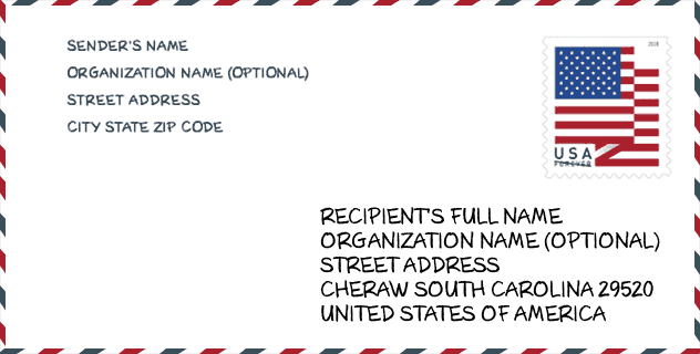
Envelope Example

This is an example of a US zip envelope. You can use a 5-digit zipcode or a detailed 9-digit zipcode to copy the mail in the following address format.
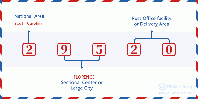
29520 Basic Meaning
What does each digit of ZIP Code 29520 stands for? The first digit designates a national area, which ranges from zero for the Northeast to nine for the far West. The 2-3 digits are the code of a sectional center facility in that region. The last two digits designate small post offices or postal zones.
Online Map

This is online map of the address Cheraw, South Carolina, United States. You may use button to move and zoom in / out. The map information is for reference only.
University

This is the ZIP Code 29520 - University page list. Its detail university Name, Street, City, State, ZIP Code, Phone is as below.
| Name | Street | City | State | ZIP Code | Phone |
| Northeastern Technical College | 1201 Chesterfield Hwy. | Cheraw | SC | 29520 | (843) 921-6900 |
Hospital

This is the ZIP Code 29520 - Hospital page list. Its detail Hospital Name, Street, City, State, ZIP Code, Phone is as below.
- Name: MCLEOD HEALTH CHERAW
- Address: CHERAW
- City: 711 CHESTERFIELD HIGHWAY
- State: SC
- ZIP Code: 29520
- Phone: (843) 537-7881
Museum

This is the ZIP Code 29520 - Museum page list. Its detail Museum Name, Street, City, State, ZIP Code, Phone is as below.
| Name | Street | City | State | ZIP Code | Phone |
| CHERAW LYCEUM MUSEUM | 200 MARKET ST | CHERAW | SC | 29520 | (843) 537-8401 |
| HISTORIC CHERAW | 230 THIRD STREET | CHERAW | SC | 29520 |
Library

This is the ZIP Code 29520 - Library page list. Its detail Library Name, Address, City, State, ZIP Code, Phone is as below.
- Name: MATHESON MEMORIAL LIBRARY
- Address: 227 HUGER STREET
- City: CHERAW
- State: SC - South Carolina
- ZIP Code: 29520
- Phone: (843) 537-3571
School
This is the ZIP Code 29520 - School page list. Its detail School Name, Address, City, State, ZIP Code is as below.
| School Name | Address | City | State | Grades | ZIP Code |
|---|---|---|---|---|---|
| Cheraw Intermediate | 421 Chesterfield Highway | Cheraw | SC | UG | 29520 |
| Cheraw Primary | 321 High Street | Cheraw | SC | UG | 29520 |
| Cheraw High | 649 Chesterfield Highway | Cheraw | SC | UG | 29520 |
| Long Middle | 1010 West Green Street | Cheraw | SC | UG | 29520 |
Population for ZIP Code 29520

What is the total population in ZIP Code 29520? Below is detail information.
- Population for ZIP Code 29520: 14,014
- 2010 Population: 14,617
The 2020 demographic statistics are in progress. The current population in ZIP code 29520 is 14,014, and the population in 2010 is 14,617.
Gender

In all the statistical population, the male population is 6,778, the female population is 7,839.
- Male Population: 6,778
- Female Population: 7,839
Race

In all the statistical population, the male population is 6,778, the female population is 7,839.
- White Population: 7,552
- Black Population: 6,924
- Hispanic Population: 153
- Asian Population: 118
- Hawaiian Population: 8
- Indian Population: 180
- Other Population: 85
Age

In all the statistical population, the White population is 7,552, the Black population is 6,924, the Hispanic population is 153, the Asian population is 118, the Hawaiian population is 8, the Indian Ppopulation is 180 and Other population is 85.
- Age's Median: 41.2
- Median of male age: 39.9
- Median of female age: 42.4
Households for ZIP Code 29520
ZIP code 29520 has 5,790 households, with an average number of 2.45 persons per household. The average income per household in Zip code 29520 is 39,784 USD, and the average house value is 94,400 USD.
- Households Per Zipcode: 5,790
- Persons Per Household: 2.45
- Average House Value: 94,400
- Income Per Household: 39,784
Geographic

The latitude of the Zip code 29520 is 34.666120, the longitude is -79.910620, and the elevation is 98. It has land area of 134.028 square miles, and water area of 2.504 square miles. The time zone for ZIP code 29520 is Eastern (GMT -05:00). Daylight saving time should be observed in the area where the zip code is located.
- Latitude: 34.666120
- Longitude: -79.910620
- Elevation: 98
- Land Area: 134.028
- Water Area: 2.504
- Time Zone: Eastern (GMT -05:00)
- Region: South
- Division: South Atlantic
- Day Light Saving: Y
Congressional District

The Congressional District for ZIP code 29520 is South Carolina's 07th congressional district, the Congressional Land Area is 5354.62 square mile.
- Congressional District: 07th
- Congressional Land Area: 5354.62
Delivery

In the ZIP code 29520, there are 5,720 residential delivery mailboxes and centralized units, and 427 commercial delivery mailbox and centralized units, 5,123 single family deliveries and 14 multifamily deliveries, and the box count is 6,758. The main post office has city delivery carrier routes for the ZIP code 29520.
- Delivery Residential: 5,720
- Delivery Business: 427
- Delivery Total: 6,758
- Single Family Delivery Units: 5,123
- Multi Family Delivery Units: 14
- City Delivery Indicator: Y
Business

In ZIP code 29520, the number of business is 289, the number of employee is 7,063, the business first quarter payroll is 74,061,000 USD, the business annual payroll is 284,031,000 USD.
- Number Of Businesses: 289
- Number Of Employees: 7,063
- Business First Quarter Payroll: 74,061,000
- Business Annual Payroll: 284,031,000
Social Security Benefits

There are 3,590 beneficiaries with benefits in current-payment status for ZIP code 29520, of which 2,415 are retired workers, 610 are disabled workers, 235 are widow(er)s and parents, 60 are spouses and 270 are children. The number of beneficiaries aged 65 or older is 2,505. The total monthly benefits are 4,659,000 USD, of which 3,399,000 USD for retired workers, 274,000 USD for widow(er)s and parents.
- Total Number: 3,590
- Retired workers Number: 2,415
- Disabled workers Number: 610
- Widow(er)s and parents Number: 235
- Spouses Number: 60
- Children Number: 270
- All beneficiaries per month: 4,659,000
- Retired workers per month: 3,399,000
- Widow(er)s and parents per month: 274,000
- Number of beneficiaries aged 65 or older: 2,505


Add new comment