United States ZIP Code: 29642
This is the South Carolina ZIP Code 29642 page list. Its detail State, County, City, Longitude, Latitude, Envelope Example, Population is as below.

ZIP Code 29642 Information

-
-
Country:
U.S. - United States
State:
State FIPS:
45
Area Code:
ZIP Code:
29642
ZIP Type:
S (Standard)
❓What does S (Standard) mean? A "standard" ZIP Code is what most people think of when they talk about ZIP Codes - essentially a town, city, or a division of a city that has mail service.
ZIP Code 29642 - City

This is the city information corresponding to 29642:
| State | County | City | City Type ?In many cases, a ZIP Code can have multiple "names", meaning cities, towns, or subdivisions, in its boundaries. However, it will ALWAYS have exactly 1 "default" name. D - Default - This is the "preferred" name - by the USPS - for a city. Each ZIP Code has one - and only one - "default" name. In most cases, this is what people who live in that area call the city as well. A - Acceptable - This name can be used for mailing purposes. Often times alternative names are large neighborhoods or sections of the city/town. In some cases a ZIP Code may have several "acceptable" names which is used to group towns under one ZIP Code. N - Not Acceptable - A "not acceptable" name is, in many cases, a nickname that residents give that location. According to the USPS, you should NOT send mail to that ZIP Code using the "not acceptable" name when mailing. | ZIP Code |
|---|---|---|---|---|
| SC | Pickens | Easley | D (Default) | 29642 |
| SC | Pickens | Powdersville | A (Acceptable) | 29642 |
❓What does D (Default) mean? This is the "preferred" name - by the USPS - for a city. Each ZIP Code has one - and only one - "default" name. In most cases, this is what people who live in that area call the city as well.
❓What does A (Acceptable) mean? This name can be used for mailing purposes. Often times alternative names are large neighborhoods or sections of the city/town. In some cases a ZIP Code may have several "acceptable" names which is used to group towns under one ZIP Code.
ZIP Code 29642 Plus 4
ZIP Code 5 plus 4 is the extension of 5-digit zip code, It can be used to locate a more detailed location. The last four digits designate segment or one side of a street or an apartment. You can find the ZIP+4 code and corresponding address of the zip code 29642 below.
| ZIP Code 5 Plus 4 | Address |
|---|---|
| 29642-0900 | 103 VENESKY WAY #A , EASLEY, SC |
| 29642-1000 | 1100 S 5TH ST, EASLEY, SC |
| 29642-1001 | 1101 S 5TH ST, EASLEY, SC |
| 29642-1002 | 1200 S 5TH ST, EASLEY, SC |
| 29642-1003 | 1201 S 5TH ST, EASLEY, SC |
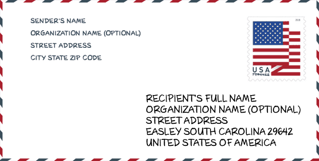
Envelope Example

This is an example of a US zip envelope. You can use a 5-digit zipcode or a detailed 9-digit zipcode to copy the mail in the following address format.
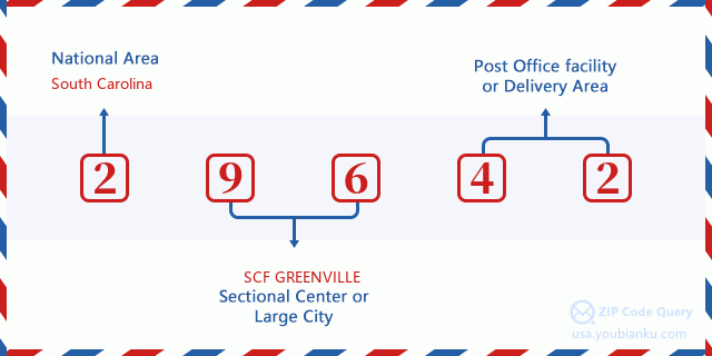
29642 Basic Meaning
What does each digit of ZIP Code 29642 stands for? The first digit designates a national area, which ranges from zero for the Northeast to nine for the far West. The 2-3 digits are the code of a sectional center facility in that region. The last two digits designate small post offices or postal zones.
Online Map

This is online map of the address Powdersville, South Carolina, United States. You may use button to move and zoom in / out. The map information is for reference only.
Library

This is the ZIP Code 29642 - Library page list. Its detail Library Name, Address, City, State, ZIP Code, Phone is as below.
- Name: POWDERSVILLE BRANCH LIBRARY
- Address: 4 CIVIC COURT
- City: EASLEY
- State: SC - South Carolina
- ZIP Code: 29642
- Phone: (864) 295-1190
School

This is the ZIP Code 29642 - School page list. Its detail School Name, Address, City, State, ZIP Code is as below.
| School Name | Address | City | State | Grades | ZIP Code |
|---|---|---|---|---|---|
| Concrete Primary | 535 Powdersville Main | Easley | SC | UG | 29642 |
| Hunt Meadows Elementary | 420 Hunt Road | Easley | SC | UG | 29642 |
| Forest Acres Elementary | 401 McAlister Road | Easley | SC | UG | 29642 |
| West End Elementary | 314 Pelzer Highway | Easley | SC | UG | 29642 |
| Easley High | 154 Green Wave Boulevard | Easley | SC | UG | 29642 |
Population for ZIP Code 29642

What is the total population in ZIP Code 29642? Below is detail information.
- Population for ZIP Code 29642: 36,270
- 2010 Population: 29,561
The 2020 demographic statistics are in progress. The current population in ZIP code 29642 is 36,270, and the population in 2010 is 29,561.
Gender

In all the statistical population, the male population is 14,343, the female population is 15,218.
- Male Population: 14,343
- Female Population: 15,218
Race

In all the statistical population, the male population is 14,343, the female population is 15,218.
- White Population: 27,045
- Black Population: 1,964
- Hispanic Population: 1,032
- Asian Population: 313
- Hawaiian Population: 18
- Indian Population: 150
- Other Population: 467
Age

In all the statistical population, the White population is 27,045, the Black population is 1,964, the Hispanic population is 1,032, the Asian population is 313, the Hawaiian population is 18, the Indian Ppopulation is 150 and Other population is 467.
- Age's Median: 40.3
- Median of male age: 39.2
- Median of female age: 41.3
Households for ZIP Code 29642
ZIP code 29642 has 11,344 households, with an average number of 2.59 persons per household. The average income per household in Zip code 29642 is 66,813 USD, and the average house value is 174,300 USD.
- Households Per Zipcode: 11,344
- Persons Per Household: 2.59
- Average House Value: 174,300
- Income Per Household: 66,813
Geographic

The latitude of the Zip code 29642 is 34.771030, the longitude is -82.566624, and the elevation is 956. It has land area of 49.762 square miles, and water area of 0.249 square miles. The time zone for ZIP code 29642 is Eastern (GMT -05:00). Daylight saving time should be observed in the area where the zip code is located.
- Latitude: 34.771030
- Longitude: -82.566624
- Elevation: 956
- Land Area: 49.762
- Water Area: 0.249
- Time Zone: Eastern (GMT -05:00)
- Region: South
- Division: South Atlantic
- Day Light Saving: Y
Congressional District

The Congressional District for ZIP code 29642 is South Carolina's 3rd congressional district, the Congressional Land Area is 5268.28 square mile.
- Congressional District: 3rd
- Congressional Land Area: 5268.28
Delivery

In the ZIP code 29642, there are 14,004 residential delivery mailboxes and centralized units, and 386 commercial delivery mailbox and centralized units, 12,471 single family deliveries and 891 multifamily deliveries, and the box count is 14,328. The main post office has city delivery carrier routes for the ZIP code 29642.
- Delivery Residential: 14,004
- Delivery Business: 386
- Delivery Total: 14,328
- Single Family Delivery Units: 12,471
- Multi Family Delivery Units: 891
- City Delivery Indicator: Y
Business

In ZIP code 29642, the number of business is 434, the number of employee is 3,998, the business first quarter payroll is 34,174,000 USD, the business annual payroll is 147,993,000 USD.
- Number Of Businesses: 434
- Number Of Employees: 3,998
- Business First Quarter Payroll: 34,174,000
- Business Annual Payroll: 147,993,000
Social Security Benefits

There are 7,975 beneficiaries with benefits in current-payment status for ZIP code 29642, of which 5,840 are retired workers, 1,025 are disabled workers, 430 are widow(er)s and parents, 200 are spouses and 480 are children. The number of beneficiaries aged 65 or older is 6,060. The total monthly benefits are 11,966,000 USD, of which 9,418,000 USD for retired workers, 619,000 USD for widow(er)s and parents.
- Total Number: 7,975
- Retired workers Number: 5,840
- Disabled workers Number: 1,025
- Widow(er)s and parents Number: 430
- Spouses Number: 200
- Children Number: 480
- All beneficiaries per month: 11,966,000
- Retired workers per month: 9,418,000
- Widow(er)s and parents per month: 619,000
- Number of beneficiaries aged 65 or older: 6,060


Add new comment