ZIP Code: 30513, Blue Ridge, GA
ZIP Code 30513 is located in Blue Ridge, Georgia. Its detail State, County, City, Longitude, Latitude, Envelope Example, Population is as below.

ZIP Code 30513 Information

-
-
Country:
U.S. - United States
State:
County FIPS:
13111
County:
City:
City Type ?In many cases, a ZIP Code can have multiple "names", meaning cities, towns, or subdivisions, in its boundaries. However, it will ALWAYS have exactly 1 "default" name. D - Default - This is the "preferred" name - by the USPS - for a city. Each ZIP Code has one - and only one - "default" name. In most cases, this is what people who live in that area call the city as well. A - Acceptable - This name can be used for mailing purposes. Often times alternative names are large neighborhoods or sections of the city/town. In some cases a ZIP Code may have several "acceptable" names which is used to group towns under one ZIP Code. N - Not Acceptable - A "not acceptable" name is, in many cases, a nickname that residents give that location. According to the USPS, you should NOT send mail to that ZIP Code using the "not acceptable" name when mailing.:
D (Default)
ZIP Code:
30513
❓What does D (Default) mean? This is the "preferred" name - by the USPS - for a city. Each ZIP Code has one - and only one - "default" name. In most cases, this is what people who live in that area call the city as well.
ZIP Code 30513 Plus 4
ZIP Code 5 plus 4 is the extension of 5-digit zip code, It can be used to locate a more detailed location. The last four digits designate segment or one side of a street or an apartment. You can find the ZIP+4 code and corresponding address of the zip code 30513 below.
| ZIP Code 5 Plus 4 | Address |
|---|---|
| 30513-0001 | PO BOX 1, BLUE RIDGE, GA |
| 30513-0002 | PO BOX 61, BLUE RIDGE, GA |
| 30513-0003 | PO BOX 121, BLUE RIDGE, GA |
| 30513-0004 | PO BOX 181, BLUE RIDGE, GA |
| 30513-0005 | PO BOX 241, BLUE RIDGE, GA |
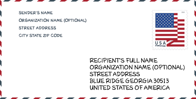
Envelope Example

This is an example of a US zip envelope. You can use a 5-digit zipcode or a detailed 9-digit zipcode to copy the mail in the following address format.
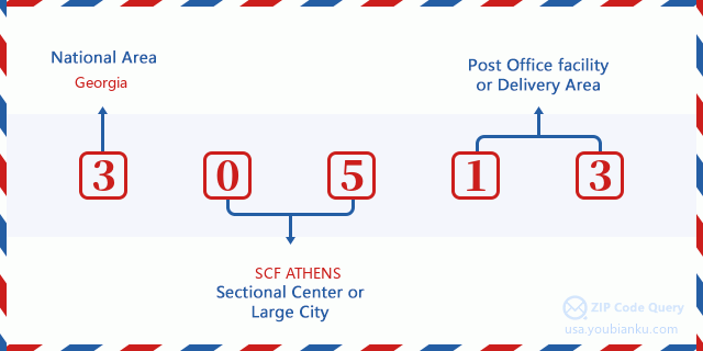
30513 Basic Meaning
What does each digit of ZIP Code 30513 stands for? The first digit designates a national area, which ranges from zero for the Northeast to nine for the far West. The 2-3 digits are the code of a sectional center facility in that region. The last two digits designate small post offices or postal zones.
Online Map

This is online map of the address Blue Ridge, Georgia, United States. You may use button to move and zoom in / out. The map information is for reference only.
Hospital

This is the ZIP Code 30513 - Hospital page list. Its detail Hospital Name, Street, City, State, ZIP Code, Phone is as below.
- Name: FANNIN REGIONAL HOSPITAL
- Address: BLUE RIDGE
- City: 2855 OLD HIGHWAY 5 NORTH
- State: GA
- ZIP Code: 30513
- Phone: (706) 632-3711
Library

This is the ZIP Code 30513 - Library page list. Its detail Library Name, Address, City, State, ZIP Code, Phone is as below.
- Name: FANNIN COUNTY PUBLIC LIBRARY
- Address: 400 WEST MAIN STREET, SUITE 104
- City: BLUE RIDGE
- State: GA - Georgia
- ZIP Code: 30513
- Phone: (706) 632-5263
School

This is the ZIP Code 30513 - School page list. Its detail School Name, Address, City, State, ZIP Code is as below.
| School Name | Address | City | State | Grades | ZIP Code |
|---|---|---|---|---|---|
| Fannin County Middle School | 4560 Old Highway 76 | Blue Ridge | GA | UG | 30513 |
| West Fannin Elementary School | 5060 Blue Ridge Dr | Blue Ridge | GA | UG | 30513 |
| Fannin County High School | 360 Rebels Cir | Blue Ridge | GA | UG | 30513 |
| Blue Ridge Elementary School | 224 E Highland St | Blue Ridge | GA | UG | 30513 |
Population for ZIP Code 30513

What is the total population in ZIP Code 30513? Below is detail information.
- Population for ZIP Code 30513: 13,224
- 2010 Population: 11,172
The 2020 demographic statistics are in progress. The current population in ZIP code 30513 is 13,224, and the population in 2010 is 11,172.
Gender

In all the statistical population, the male population is 5,416, the female population is 5,756.
- Male Population: 5,416
- Female Population: 5,756
Race

In all the statistical population, the male population is 5,416, the female population is 5,756.
- White Population: 10,948
- Black Population: 61
- Hispanic Population: 295
- Asian Population: 45
- Hawaiian Population: 5
- Indian Population: 126
- Other Population: 131
Age

In all the statistical population, the White population is 10,948, the Black population is 61, the Hispanic population is 295, the Asian population is 45, the Hawaiian population is 5, the Indian Ppopulation is 126 and Other population is 131.
- Age's Median: 48.0
- Median of male age: 47.0
- Median of female age: 49.1
Households for ZIP Code 30513
ZIP code 30513 has 4,821 households, with an average number of 2.28 persons per household. The average income per household in Zip code 30513 is 47,549 USD, and the average house value is 189,600 USD.
- Households Per Zipcode: 4,821
- Persons Per Household: 2.28
- Average House Value: 189,600
- Income Per Household: 47,549
Geographic

The latitude of the Zip code 30513 is 34.793329, the longitude is -84.327390, and the elevation is 2609. It has land area of 148.599 square miles, and water area of 2.378 square miles. The time zone for ZIP code 30513 is Eastern (GMT -05:00). Daylight saving time should be observed in the area where the zip code is located.
- Latitude: 34.793329
- Longitude: -84.327390
- Elevation: 2609
- Land Area: 148.599
- Water Area: 2.378
- Time Zone: Eastern (GMT -05:00)
- Region: South
- Division: South Atlantic
- Day Light Saving: Y
Congressional District

The Congressional District for ZIP code 30513 is Georgia's 09th congressional district, the Congressional Land Area is 5210.81 square mile.
- Congressional District: 09th
- Congressional Land Area: 5210.81
Delivery

In the ZIP code 30513, there are 5,800 residential delivery mailboxes and centralized units, and 652 commercial delivery mailbox and centralized units, 4,618 single family deliveries and 0 multifamily deliveries, and the box count is 8,586. The main post office does not have city delivery carrier routes for the ZIP code 30513.
- Delivery Residential: 5,800
- Delivery Business: 652
- Delivery Total: 8,586
- Single Family Delivery Units: 4,618
- Multi Family Delivery Units: 0
- City Delivery Indicator: N
Business

In ZIP code 30513, the number of business is 463, the number of employee is 4,509, the business first quarter payroll is 32,014,000 USD, the business annual payroll is 137,529,000 USD.
- Number Of Businesses: 463
- Number Of Employees: 4,509
- Business First Quarter Payroll: 32,014,000
- Business Annual Payroll: 137,529,000
Social Security Benefits

There are 4,210 beneficiaries with benefits in current-payment status for ZIP code 30513, of which 3,100 are retired workers, 515 are disabled workers, 275 are widow(er)s and parents, 115 are spouses and 205 are children. The number of beneficiaries aged 65 or older is 3,225. The total monthly benefits are 5,797,000 USD, of which 4,565,000 USD for retired workers, 368,000 USD for widow(er)s and parents.
- Total Number: 4,210
- Retired workers Number: 3,100
- Disabled workers Number: 515
- Widow(er)s and parents Number: 275
- Spouses Number: 115
- Children Number: 205
- All beneficiaries per month: 5,797,000
- Retired workers per month: 4,565,000
- Widow(er)s and parents per month: 368,000
- Number of beneficiaries aged 65 or older: 3,225


Add new comment