ZIP Code: 30720, Dalton, GA
ZIP Code 30720 is located in Dalton, Georgia. Its detail State, County, City, Longitude, Latitude, Envelope Example, Population is as below.
ZIP Code 30720 Information

-
-
Country:
U.S. - United States
State:
County FIPS:
13313
City:
City Type ?In many cases, a ZIP Code can have multiple "names", meaning cities, towns, or subdivisions, in its boundaries. However, it will ALWAYS have exactly 1 "default" name. D - Default - This is the "preferred" name - by the USPS - for a city. Each ZIP Code has one - and only one - "default" name. In most cases, this is what people who live in that area call the city as well. A - Acceptable - This name can be used for mailing purposes. Often times alternative names are large neighborhoods or sections of the city/town. In some cases a ZIP Code may have several "acceptable" names which is used to group towns under one ZIP Code. N - Not Acceptable - A "not acceptable" name is, in many cases, a nickname that residents give that location. According to the USPS, you should NOT send mail to that ZIP Code using the "not acceptable" name when mailing.:
D (Default)
ZIP Code:
30720
❓What does D (Default) mean? This is the "preferred" name - by the USPS - for a city. Each ZIP Code has one - and only one - "default" name. In most cases, this is what people who live in that area call the city as well.
ZIP Code 30720 Plus 4
ZIP Code 5 plus 4 is the extension of 5-digit zip code, It can be used to locate a more detailed location. The last four digits designate segment or one side of a street or an apartment. You can find the ZIP+4 code and corresponding address of the zip code 30720 below.
| ZIP Code 5 Plus 4 | Address |
|---|---|
| 30720-0300 | 1108 WALSTON ST #C100 , DALTON, GA |
| 30720-0301 | 1108 WALSTON ST #C110 , DALTON, GA |
| 30720-0302 | 1108 WALSTON ST #C101 , DALTON, GA |
| 30720-0303 | 1108 WALSTON ST #C111 , DALTON, GA |
| 30720-0304 | 1108 WALSTON ST #C102 , DALTON, GA |
Envelope Example

This is an example of a US zip envelope. You can use a 5-digit zipcode or a detailed 9-digit zipcode to copy the mail in the following address format.

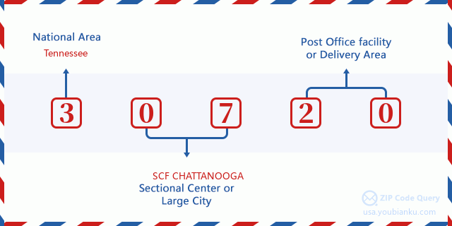
30720 Basic Meaning
What does each digit of ZIP Code 30720 stands for? The first digit designates a national area, which ranges from zero for the Northeast to nine for the far West. The 2-3 digits are the code of a sectional center facility in that region. The last two digits designate small post offices or postal zones.
Online Map

This is online map of the address Dalton, Georgia, United States. You may use button to move and zoom in / out. The map information is for reference only.
Hospital

This is the ZIP Code 30720 - Hospital page list. Its detail Hospital Name, Street, City, State, ZIP Code, Phone is as below.
- Name: HAMILTON MEDICAL CENTER
- Address: DALTON
- City: 1200 MEMORIAL DRIVE
- State: GA
- ZIP Code: 30720
- Phone: (706) 272-6105
Library

This is the ZIP Code 30720 - Library page list. Its detail Library Name, Address, City, State, ZIP Code, Phone is as below.
| Name | Address | City | State | ZIP Code | Phone |
|---|---|---|---|---|---|
| DALTON-WHITFIELD COUNTY LIBRARY | 310 CAPPES STREET | DALTON | GA | 30720 | (706) 876-1360 |
| NORTHWEST GEORGIA REGIONAL LIBRARY SYSTEM | 310 CAPPES STREET | DALTON | GA | 30720 | (706) 876-1360 |
School

This is the ZIP Code 30720 - School page list. Its detail School Name, Address, City, State, ZIP Code is as below.
| School Name | Address | City | State | Grades | ZIP Code |
|---|---|---|---|---|---|
| Brookwood Elementary School | 501 Central Ave | Dalton | GA | UG | 30720 |
| Dalton High School | 1500 Manley St | Dalton | GA | UG | 30720 |
| Westwood Elementary School | 708 Trammell St | Dalton | GA | UG | 30720 |
| City Park Elementary School | 405 School St | Dalton | GA | UG | 30720 |
| Dug Gap Elementary School | 2032 Dug Gap Rd | Dalton | GA | UG | 30720 |
| New Hope Elementary School | 1175 New Hope Rd NW | Dalton | GA | UG | 30720 |
| New Hope Middle School | 1111 New Hope Rd NW | Dalton | GA | UG | 30720 |
Population for ZIP Code 30720

What is the total population in ZIP Code 30720? Below is detail information.
- Population for ZIP Code 30720: 27,030
- 2010 Population: 26,895
The 2020 demographic statistics are in progress. The current population in ZIP code 30720 is 27,030, and the population in 2010 is 26,895.
Gender

In all the statistical population, the male population is 13,247, the female population is 13,648.
- Male Population: 13,247
- Female Population: 13,648
Race

In all the statistical population, the male population is 13,247, the female population is 13,648.
- White Population: 20,727
- Black Population: 1,379
- Hispanic Population: 8,202
- Asian Population: 875
- Hawaiian Population: 23
- Indian Population: 311
- Other Population: 4,270
Age

In all the statistical population, the White population is 20,727, the Black population is 1,379, the Hispanic population is 8,202, the Asian population is 875, the Hawaiian population is 23, the Indian Ppopulation is 311 and Other population is 4,270.
- Age's Median: 35.4
- Median of male age: 33.6
- Median of female age: 37.0
Households for ZIP Code 30720
ZIP code 30720 has 9,804 households, with an average number of 2.66 persons per household. The average income per household in Zip code 30720 is 51,449 USD, and the average house value is 158,800 USD.
- Households Per Zipcode: 9,804
- Persons Per Household: 2.66
- Average House Value: 158,800
- Income Per Household: 51,449
Geographic

The latitude of the Zip code 30720 is 34.759532, the longitude is -85.005494, and the elevation is 1121. It has land area of 48.561 square miles, and water area of 0.14 square miles. The time zone for ZIP code 30720 is Eastern (GMT -05:00). Daylight saving time should be observed in the area where the zip code is located.
- Latitude: 34.759532
- Longitude: -85.005494
- Elevation: 1121
- Land Area: 48.561
- Water Area: 0.14
- Time Zone: Eastern (GMT -05:00)
- Region: South
- Division: South Atlantic
- Day Light Saving: Y
Congressional District

The Congressional District for ZIP code 30720 is Georgia's 14th congressional district, the Congressional Land Area is 3623.16 square mile.
- Congressional District: 14th
- Congressional Land Area: 3623.16
Delivery

In the ZIP code 30720, there are 10,162 residential delivery mailboxes and centralized units, and 1,388 commercial delivery mailbox and centralized units, 7,543 single family deliveries and 1,780 multifamily deliveries, and the box count is 11,345. The main post office has city delivery carrier routes for the ZIP code 30720.
- Delivery Residential: 10,162
- Delivery Business: 1,388
- Delivery Total: 11,345
- Single Family Delivery Units: 7,543
- Multi Family Delivery Units: 1,780
- City Delivery Indicator: Y
Business

In ZIP code 30720, the number of business is 1,022, the number of employee is 23,075, the business first quarter payroll is 256,773,000 USD, the business annual payroll is 1,060,709,000 USD.
- Number Of Businesses: 1,022
- Number Of Employees: 23,075
- Business First Quarter Payroll: 256,773,000
- Business Annual Payroll: 1,060,709,000
Social Security Benefits

There are 4,730 beneficiaries with benefits in current-payment status for ZIP code 30720, of which 3,340 are retired workers, 655 are disabled workers, 270 are widow(er)s and parents, 195 are spouses and 270 are children. The number of beneficiaries aged 65 or older is 3,575. The total monthly benefits are 6,703,000 USD, of which 5,203,000 USD for retired workers, 354,000 USD for widow(er)s and parents.
- Total Number: 4,730
- Retired workers Number: 3,340
- Disabled workers Number: 655
- Widow(er)s and parents Number: 270
- Spouses Number: 195
- Children Number: 270
- All beneficiaries per month: 6,703,000
- Retired workers per month: 5,203,000
- Widow(er)s and parents per month: 354,000
- Number of beneficiaries aged 65 or older: 3,575


Add new comment