ZIP Code: 31047, Kathleen, GA
ZIP Code 31047 is located in Kathleen, Georgia. Its detail State, County, City, Longitude, Latitude, Envelope Example, Population is as below.

ZIP Code 31047 Information

-
-
Country:
U.S. - United States
State:
County FIPS:
13153
County:
City:
Area Code:
City Type ?In many cases, a ZIP Code can have multiple "names", meaning cities, towns, or subdivisions, in its boundaries. However, it will ALWAYS have exactly 1 "default" name. D - Default - This is the "preferred" name - by the USPS - for a city. Each ZIP Code has one - and only one - "default" name. In most cases, this is what people who live in that area call the city as well. A - Acceptable - This name can be used for mailing purposes. Often times alternative names are large neighborhoods or sections of the city/town. In some cases a ZIP Code may have several "acceptable" names which is used to group towns under one ZIP Code. N - Not Acceptable - A "not acceptable" name is, in many cases, a nickname that residents give that location. According to the USPS, you should NOT send mail to that ZIP Code using the "not acceptable" name when mailing.:
D (Default)
ZIP Code:
31047
❓What does D (Default) mean? This is the "preferred" name - by the USPS - for a city. Each ZIP Code has one - and only one - "default" name. In most cases, this is what people who live in that area call the city as well.
ZIP Code 31047 Plus 4
ZIP Code 5 plus 4 is the extension of 5-digit zip code, It can be used to locate a more detailed location. The last four digits designate segment or one side of a street or an apartment. You can find the ZIP+4 code and corresponding address of the zip code 31047 below.
| ZIP Code 5 Plus 4 | Address |
|---|---|
| 31047-0001 | PO BOX 1, KATHLEEN, GA |
| 31047-0121 | PO BOX 121, KATHLEEN, GA |
| 31047-0241 | PO BOX 241, KATHLEEN, GA |
| 31047-0361 | PO BOX 361, KATHLEEN, GA |
| 31047-1400 | 101 BLACK HAWKE LN, KATHLEEN, GA |
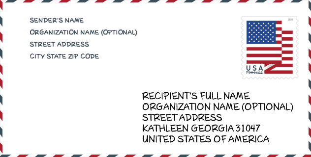
Envelope Example

This is an example of a US zip envelope. You can use a 5-digit zipcode or a detailed 9-digit zipcode to copy the mail in the following address format.
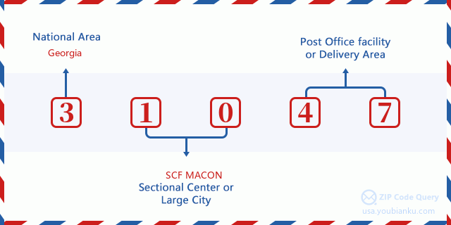
31047 Basic Meaning
What does each digit of ZIP Code 31047 stands for? The first digit designates a national area, which ranges from zero for the Northeast to nine for the far West. The 2-3 digits are the code of a sectional center facility in that region. The last two digits designate small post offices or postal zones.
Online Map

This is online map of the address Kathleen, Georgia, United States. You may use button to move and zoom in / out. The map information is for reference only.
School

This is the ZIP Code 31047 - School page list. Its detail School Name, Address, City, State, ZIP Code is as below.
| School Name | Address | City | State | Grades | ZIP Code |
|---|---|---|---|---|---|
| Matthew Arthur Elementary School | 2500 Ga Highway 127 | Kathleen | GA | UG | 31047 |
| Mossy Creek Middle School | 200 Danny Carpenter Dr | Kathleen | GA | UG | 31047 |
| Veterans High School | 340 Piney Grove Rd | Kathleen | GA | UG | 31047 |
Population for ZIP Code 31047

What is the total population in ZIP Code 31047? Below is detail information.
- Population for ZIP Code 31047: 17,216
- 2010 Population: 11,193
The 2020 demographic statistics are in progress. The current population in ZIP code 31047 is 17,216, and the population in 2010 is 11,193.
Gender

In all the statistical population, the male population is 5,574, the female population is 5,619.
- Male Population: 5,574
- Female Population: 5,619
Race

In all the statistical population, the male population is 5,574, the female population is 5,619.
- White Population: 8,887
- Black Population: 1,902
- Hispanic Population: 440
- Asian Population: 404
- Hawaiian Population: 23
- Indian Population: 119
- Other Population: 156
Age

In all the statistical population, the White population is 8,887, the Black population is 1,902, the Hispanic population is 440, the Asian population is 404, the Hawaiian population is 23, the Indian Ppopulation is 119 and Other population is 156.
- Age's Median: 36.0
- Median of male age: 35.7
- Median of female age: 36.2
Households for ZIP Code 31047
ZIP code 31047 has 3,927 households, with an average number of 2.85 persons per household. The average income per household in Zip code 31047 is 82,301 USD, and the average house value is 190,900 USD.
- Households Per Zipcode: 3,927
- Persons Per Household: 2.85
- Average House Value: 190,900
- Income Per Household: 82,301
Housing Unit

In ZIP code 31047, the growth rank of housing unit is 68, the number of housing unit was 139,911 in 2010 and increased to 143,925 in 2011, the growth increase number is 4,014, the growth increase percentage is 2.9%.
- Growth Rank: 68
- Housing Units Estimate in 2010: 139,911
- Housing Units Estimate in 2011: 143,925
- Growth Increase Number: 4,014
- Growth Increase Percentage: 2.9%
Geographic

The latitude of the Zip code 31047 is 32.463087, the longitude is -83.602004, and the elevation is 282. It has land area of 71.886 square miles, and water area of 1.245 square miles. The time zone for ZIP code 31047 is Eastern (GMT -05:00). Daylight saving time should be observed in the area where the zip code is located.
- Latitude: 32.463087
- Longitude: -83.602004
- Elevation: 282
- Land Area: 71.886
- Water Area: 1.245
- Time Zone: Eastern (GMT -05:00)
- Region: South
- Division: South Atlantic
- Day Light Saving: Y
Congressional District

The Congressional District for ZIP code 31047 is Georgia's 08th congressional district, the Congressional Land Area is 8711.64 square mile.
- Congressional District: 08th
- Congressional Land Area: 8711.64
Delivery

In the ZIP code 31047, there are 6,041 residential delivery mailboxes and centralized units, and 92 commercial delivery mailbox and centralized units, 5,041 single family deliveries and 180 multifamily deliveries, and the box count is 6,268. The main post office does not have city delivery carrier routes for the ZIP code 31047.
- Delivery Residential: 6,041
- Delivery Business: 92
- Delivery Total: 6,268
- Single Family Delivery Units: 5,041
- Multi Family Delivery Units: 180
- City Delivery Indicator: N
Business

In ZIP code 31047, the number of business is 104, the number of employee is 2,538, the business first quarter payroll is 30,689,000 USD, the business annual payroll is 120,394,000 USD.
- Number Of Businesses: 104
- Number Of Employees: 2,538
- Business First Quarter Payroll: 30,689,000
- Business Annual Payroll: 120,394,000
Social Security Benefits

There are 2,155 beneficiaries with benefits in current-payment status for ZIP code 31047, of which 1,445 are retired workers, 315 are disabled workers, 130 are widow(er)s and parents, 70 are spouses and 195 are children. The number of beneficiaries aged 65 or older is 1,470. The total monthly benefits are 2,847,000 USD, of which 2,072,000 USD for retired workers, 160,000 USD for widow(er)s and parents.
- Total Number: 2,155
- Retired workers Number: 1,445
- Disabled workers Number: 315
- Widow(er)s and parents Number: 130
- Spouses Number: 70
- Children Number: 195
- All beneficiaries per month: 2,847,000
- Retired workers per month: 2,072,000
- Widow(er)s and parents per month: 160,000
- Number of beneficiaries aged 65 or older: 1,470


Add new comment