ZIP Code: 35811, Huntsville, AL
ZIP Code 35811 is located in Huntsville, Alabama. Its detail State, County, City, Longitude, Latitude, Envelope Example, Population is as below.
ZIP Code 35811 Information

-
-
Country:
U.S. - United States
State:
County FIPS:
01089
County:
City:
Area Code:
City Type ?In many cases, a ZIP Code can have multiple "names", meaning cities, towns, or subdivisions, in its boundaries. However, it will ALWAYS have exactly 1 "default" name. D - Default - This is the "preferred" name - by the USPS - for a city. Each ZIP Code has one - and only one - "default" name. In most cases, this is what people who live in that area call the city as well. A - Acceptable - This name can be used for mailing purposes. Often times alternative names are large neighborhoods or sections of the city/town. In some cases a ZIP Code may have several "acceptable" names which is used to group towns under one ZIP Code. N - Not Acceptable - A "not acceptable" name is, in many cases, a nickname that residents give that location. According to the USPS, you should NOT send mail to that ZIP Code using the "not acceptable" name when mailing.:
D (Default)
ZIP Code:
35811
❓What does D (Default) mean? This is the "preferred" name - by the USPS - for a city. Each ZIP Code has one - and only one - "default" name. In most cases, this is what people who live in that area call the city as well.
ZIP Code 35811 Plus 4
ZIP Code 5 plus 4 is the extension of 5-digit zip code, It can be used to locate a more detailed location. The last four digits designate segment or one side of a street or an apartment. You can find the ZIP+4 code and corresponding address of the zip code 35811 below.
| ZIP Code 5 Plus 4 | Address |
|---|---|
| 35811-1000 | 5021 MOORES MILL RD, HUNTSVILLE, AL |
| 35811-1001 | 5001 COLEMONT LN, HUNTSVILLE, AL |
| 35811-1002 | 5000 COLEMONT LN, HUNTSVILLE, AL |
| 35811-1003 | 5101 COLEMONT LN, HUNTSVILLE, AL |
| 35811-1004 | 5100 COLEMONT LN, HUNTSVILLE, AL |
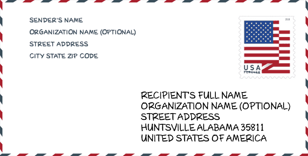
Envelope Example

This is an example of a US zip envelope. You can use a 5-digit zipcode or a detailed 9-digit zipcode to copy the mail in the following address format.
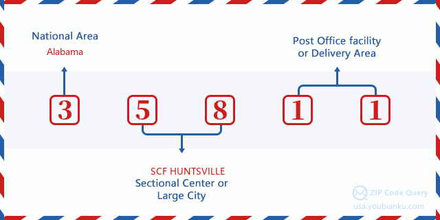
35811 Basic Meaning
What does each digit of ZIP Code 35811 stands for? The first digit designates a national area, which ranges from zero for the Northeast to nine for the far West. The 2-3 digits are the code of a sectional center facility in that region. The last two digits designate small post offices or postal zones.
Online Map

This is online map of the address Huntsville, Alabama, United States. You may use button to move and zoom in / out. The map information is for reference only.
University

This is the ZIP Code 35811 - University page list. Its detail university Name, Street, City, State, ZIP Code, Phone is as below.
| Name | Street | City | State | ZIP Code | Phone |
| J F Drake State Community and Technical College | 3421 Meridian St N | Huntsville | AL | 35811 | - |
| J. F. Drake State Community and Technical College | 3421 Meridian St N | Huntsville | AL | 35811 | (256) 539-8161 |
School
This is the ZIP Code 35811 - School page list. Its detail School Name, Address, City, State, ZIP Code is as below.
| School Name | Address | City | State | Grades | ZIP Code |
|---|---|---|---|---|---|
| New Century Technology High School | 2500 Meridian Street NW | Huntsville | AL | 09-12 | 35811 |
| Chapman Middle School | 2006 Reuben Dr NE | Huntsville | AL | 06-08 | 35811 |
| Madison County Alternative School | 1275 Jordan Rd | Huntsville | AL | 01-12 | 35811 |
| Madison County Career Technical Center | 1275 Jordan Rd Bldg A | Huntsville | AL | 09-12 | 35811 |
| Mt Carmel Elementary School | 335 Homer Nance Road | Huntsville | AL | PK-03 | 35811 |
| Central School | 990 Ryland Pike | Huntsville | AL | PK-08 | 35811 |
| Riverton Elementary School | 2615 Winchester Road | Huntsville | AL | PK-03 | 35811 |
| Riverton Intermediate School | 399 Homer Nance Road | Huntsville | AL | 04-06 | 35811 |
| Madison County Virtual Academy | 1275 Jordan Rd Building A | Huntsville | AL | 04-12 | 35811 |
Population for ZIP Code 35811

What is the total population in ZIP Code 35811? Below is detail information.
- Population for ZIP Code 35811: 30,006
- 2010 Population: 25,955
The 2020 demographic statistics are in progress. The current population in ZIP code 35811 is 30,006, and the population in 2010 is 25,955.
Gender

In all the statistical population, the male population is 12,715, the female population is 13,240.
- Male Population: 12,715
- Female Population: 13,240
Race

In all the statistical population, the male population is 12,715, the female population is 13,240.
- White Population: 18,795
- Black Population: 6,584
- Hispanic Population: 665
- Asian Population: 410
- Hawaiian Population: 19
- Indian Population: 471
- Other Population: 266
Age

In all the statistical population, the White population is 18,795, the Black population is 6,584, the Hispanic population is 665, the Asian population is 410, the Hawaiian population is 19, the Indian Ppopulation is 471 and Other population is 266.
- Age's Median: 39.8
- Median of male age: 39.1
- Median of female age: 40.4
Households for ZIP Code 35811
ZIP code 35811 has 10,202 households, with an average number of 2.49 persons per household. The average income per household in Zip code 35811 is 62,688 USD, and the average house value is 164,100 USD.
- Households Per Zipcode: 10,202
- Persons Per Household: 2.49
- Average House Value: 164,100
- Income Per Household: 62,688
Geographic

The latitude of the Zip code 35811 is 34.813620, the longitude is -86.503450, and the elevation is 727. It has land area of 46.245 square miles, and water area of 0.51 square miles. The time zone for ZIP code 35811 is Central (GMT -06:00). Daylight saving time should be observed in the area where the zip code is located.
- Latitude: 34.813620
- Longitude: -86.503450
- Elevation: 727
- Land Area: 46.245
- Water Area: 0.51
- Time Zone: Central (GMT -06:00)
- Region: South
- Division: East South Central
- Day Light Saving: Y
Congressional District

The Congressional District for ZIP code 35811 is Alabama's 05th congressional district, the Congressional Land Area is 3677.31 square mile.
- Congressional District: 05th
- Congressional Land Area: 3677.31
Delivery

In the ZIP code 35811, there are 12,051 residential delivery mailboxes and centralized units, and 614 commercial delivery mailbox and centralized units, 11,436 single family deliveries and 152 multifamily deliveries, and the box count is 13,145. The main post office has city delivery carrier routes for the ZIP code 35811.
- Delivery Residential: 12,051
- Delivery Business: 614
- Delivery Total: 13,145
- Single Family Delivery Units: 11,436
- Multi Family Delivery Units: 152
- City Delivery Indicator: Y
Business

In ZIP code 35811, the number of business is 417, the number of employee is 8,180, the business first quarter payroll is 90,401,000 USD, the business annual payroll is 343,252,000 USD.
- Number Of Businesses: 417
- Number Of Employees: 8,180
- Business First Quarter Payroll: 90,401,000
- Business Annual Payroll: 343,252,000
Social Security Benefits

There are 5,755 beneficiaries with benefits in current-payment status for ZIP code 35811, of which 4,000 are retired workers, 845 are disabled workers, 365 are widow(er)s and parents, 170 are spouses and 375 are children. The number of beneficiaries aged 65 or older is 4,215. The total monthly benefits are 7,986,000 USD, of which 6,006,000 USD for retired workers, 503,000 USD for widow(er)s and parents.
- Total Number: 5,755
- Retired workers Number: 4,000
- Disabled workers Number: 845
- Widow(er)s and parents Number: 365
- Spouses Number: 170
- Children Number: 375
- All beneficiaries per month: 7,986,000
- Retired workers per month: 6,006,000
- Widow(er)s and parents per month: 503,000
- Number of beneficiaries aged 65 or older: 4,215


Add new comment