ZIP Code: 35967, Fort Payne, AL
ZIP Code 35967 is located in Fort Payne, Alabama. Its detail State, County, City, Longitude, Latitude, Envelope Example, Population is as below.
ZIP Code 35967 Information

-
-
Country:
U.S. - United States
State:
County FIPS:
01049
County:
City:
Area Code:
City Type ?In many cases, a ZIP Code can have multiple "names", meaning cities, towns, or subdivisions, in its boundaries. However, it will ALWAYS have exactly 1 "default" name. D - Default - This is the "preferred" name - by the USPS - for a city. Each ZIP Code has one - and only one - "default" name. In most cases, this is what people who live in that area call the city as well. A - Acceptable - This name can be used for mailing purposes. Often times alternative names are large neighborhoods or sections of the city/town. In some cases a ZIP Code may have several "acceptable" names which is used to group towns under one ZIP Code. N - Not Acceptable - A "not acceptable" name is, in many cases, a nickname that residents give that location. According to the USPS, you should NOT send mail to that ZIP Code using the "not acceptable" name when mailing.:
D (Default)
ZIP Code:
35967
❓What does D (Default) mean? This is the "preferred" name - by the USPS - for a city. Each ZIP Code has one - and only one - "default" name. In most cases, this is what people who live in that area call the city as well.
ZIP Code 35967 Plus 4
ZIP Code 5 plus 4 is the extension of 5-digit zip code, It can be used to locate a more detailed location. The last four digits designate segment or one side of a street or an apartment. You can find the ZIP+4 code and corresponding address of the zip code 35967 below.
| ZIP Code 5 Plus 4 | Address |
|---|---|
| 35967-0001 | 1 COUNTY ROAD 369, FORT PAYNE, AL |
| 35967-0002 | 101 ROAD 1917, FORT PAYNE, AL |
| 35967-0003 | 100 ROAD 1917, FORT PAYNE, AL |
| 35967-0004 | 1 ROAD 1917, FORT PAYNE, AL |
| 35967-0005 | 2 ROAD 1917, FORT PAYNE, AL |
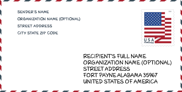
Envelope Example

This is an example of a US zip envelope. You can use a 5-digit zipcode or a detailed 9-digit zipcode to copy the mail in the following address format.
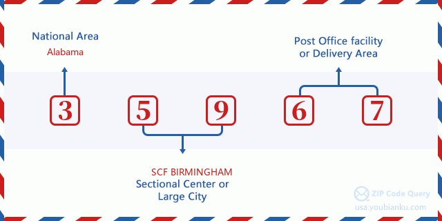
35967 Basic Meaning
What does each digit of ZIP Code 35967 stands for? The first digit designates a national area, which ranges from zero for the Northeast to nine for the far West. The 2-3 digits are the code of a sectional center facility in that region. The last two digits designate small post offices or postal zones.
Online Map

This is online map of the address Fort Payne, Alabama, United States. You may use button to move and zoom in / out. The map information is for reference only.
Museum

This is the ZIP Code 35967 - Museum page list. Its detail Museum Name, Street, City, State, ZIP Code, Phone is as below.
| Name | Street | City | State | ZIP Code | Phone |
| DEPOT MUSEUM | N 5TH ST | FORT PAYNE | AL | 35967 | (256) 845-5714 |
| LITTLE RIVER CANYON NATIONAL PRESERVE | 4322 LITTLE RIVER TRAIL NE | FORT PAYNE | AL | 35967 | (256) 845-9605 |
| ALABAMA FAN CLUB AND MUSEUM | 101 GLENN BOULEVARD SW | FORT PAYNE | AL | 35967 |
Library

This is the ZIP Code 35967 - Library page list. Its detail Library Name, Address, City, State, ZIP Code, Phone is as below.
| Name | Address | City | State | ZIP Code | Phone |
|---|---|---|---|---|---|
| FORT PAYNE - DEKALB COUNTY BOOKMOBILE | 504 GRAND AVENUE NW | FORT PAYNE | AL | 35967 | |
| FORT PAYNE - DEKALB COUNTY PUBLIC LIBRARY | 504 GRAND AVENUE NW | FORT PAYNE | AL | 35967 | (256) 845-2671 |
School

This is the ZIP Code 35967 - School page list. Its detail School Name, Address, City, State, ZIP Code is as below.
| School Name | Address | City | State | Grades | ZIP Code |
|---|---|---|---|---|---|
| Alternative School | 155 20th Street NE | Fort Payne | AL | 05-12 | 35967 |
| Fort Payne High School | 201 45th St NE | Fort Payne | AL | 09-12 | 35967 |
| Wills Valley Elementary School | 4111 Williams Ave NE | Fort Payne | AL | PK-02 | 35967 |
| Fort Payne Middle School | 4910 Martin Ave NE | Fort Payne | AL | 06-08 | 35967 |
| Little Ridge Intermediate School | 201 45th St NE | Fort Payne | AL | 03-05 | 35967 |
Population for ZIP Code 35967

What is the total population in ZIP Code 35967? Below is detail information.
- Population for ZIP Code 35967: 17,425
- 2010 Population: 16,630
The 2020 demographic statistics are in progress. The current population in ZIP code 35967 is 17,425, and the population in 2010 is 16,630.
Gender

In all the statistical population, the male population is 8,121, the female population is 8,509.
- Male Population: 8,121
- Female Population: 8,509
Race

In all the statistical population, the male population is 8,121, the female population is 8,509.
- White Population: 13,712
- Black Population: 719
- Hispanic Population: 2,996
- Asian Population: 150
- Hawaiian Population: 53
- Indian Population: 335
- Other Population: 2,099
Age

In all the statistical population, the White population is 13,712, the Black population is 719, the Hispanic population is 2,996, the Asian population is 150, the Hawaiian population is 53, the Indian Ppopulation is 335 and Other population is 2,099.
- Age's Median: 36.5
- Median of male age: 35.3
- Median of female age: 38.0
Households for ZIP Code 35967
ZIP code 35967 has 6,372 households, with an average number of 2.59 persons per household. The average income per household in Zip code 35967 is 39,746 USD, and the average house value is 112,000 USD.
- Households Per Zipcode: 6,372
- Persons Per Household: 2.59
- Average House Value: 112,000
- Income Per Household: 39,746
Geographic

The latitude of the Zip code 35967 is 34.407120, the longitude is -85.704552, and the elevation is 1414. It has land area of 124.998 square miles, and water area of 0.34 square miles. The time zone for ZIP code 35967 is Central (GMT -06:00). Daylight saving time should be observed in the area where the zip code is located.
- Latitude: 34.407120
- Longitude: -85.704552
- Elevation: 1414
- Land Area: 124.998
- Water Area: 0.34
- Time Zone: Central (GMT -06:00)
- Region: South
- Division: East South Central
- Day Light Saving: Y
Congressional District

The Congressional District for ZIP code 35967 is Alabama's 3rd|04th congressional district, the Congressional Land Area is 7543.86|8888.77 square mile.
- Congressional District: 3rd|04th
- Congressional Land Area: 7543.86|8888.77
Delivery

In the ZIP code 35967, there are 6,728 residential delivery mailboxes and centralized units, and 695 commercial delivery mailbox and centralized units, 5,769 single family deliveries and 465 multifamily deliveries, and the box count is 7,421. The main post office has city delivery carrier routes for the ZIP code 35967.
- Delivery Residential: 6,728
- Delivery Business: 695
- Delivery Total: 7,421
- Single Family Delivery Units: 5,769
- Multi Family Delivery Units: 465
- City Delivery Indicator: Y
Business

In ZIP code 35967, the number of business is 408, the number of employee is 7,292, the business first quarter payroll is 71,093,000 USD, the business annual payroll is 299,810,000 USD.
- Number Of Businesses: 408
- Number Of Employees: 7,292
- Business First Quarter Payroll: 71,093,000
- Business Annual Payroll: 299,810,000
Social Security Benefits

There are 3,660 beneficiaries with benefits in current-payment status for ZIP code 35967, of which 2,350 are retired workers, 655 are disabled workers, 245 are widow(er)s and parents, 90 are spouses and 320 are children. The number of beneficiaries aged 65 or older is 2,470. The total monthly benefits are 4,601,000 USD, of which 3,238,000 USD for retired workers, 301,000 USD for widow(er)s and parents.
- Total Number: 3,660
- Retired workers Number: 2,350
- Disabled workers Number: 655
- Widow(er)s and parents Number: 245
- Spouses Number: 90
- Children Number: 320
- All beneficiaries per month: 4,601,000
- Retired workers per month: 3,238,000
- Widow(er)s and parents per month: 301,000
- Number of beneficiaries aged 65 or older: 2,470


Add new comment