ZIP Code: 36022, Deatsville, AL
ZIP Code 36022 is located in Deatsville, Alabama. Its detail State, County, City, Longitude, Latitude, Envelope Example, Population is as below.

ZIP Code 36022 Information

-
-
Country:
U.S. - United States
State:
County FIPS:
01051
County:
City:
Area Code:
City Type ?In many cases, a ZIP Code can have multiple "names", meaning cities, towns, or subdivisions, in its boundaries. However, it will ALWAYS have exactly 1 "default" name. D - Default - This is the "preferred" name - by the USPS - for a city. Each ZIP Code has one - and only one - "default" name. In most cases, this is what people who live in that area call the city as well. A - Acceptable - This name can be used for mailing purposes. Often times alternative names are large neighborhoods or sections of the city/town. In some cases a ZIP Code may have several "acceptable" names which is used to group towns under one ZIP Code. N - Not Acceptable - A "not acceptable" name is, in many cases, a nickname that residents give that location. According to the USPS, you should NOT send mail to that ZIP Code using the "not acceptable" name when mailing.:
D (Default)
ZIP Code:
36022
❓What does D (Default) mean? This is the "preferred" name - by the USPS - for a city. Each ZIP Code has one - and only one - "default" name. In most cases, this is what people who live in that area call the city as well.
ZIP Code 36022 Plus 4
ZIP Code 5 plus 4 is the extension of 5-digit zip code, It can be used to locate a more detailed location. The last four digits designate segment or one side of a street or an apartment. You can find the ZIP+4 code and corresponding address of the zip code 36022 below.
| ZIP Code 5 Plus 4 | Address |
|---|---|
| 36022-0001 | PO BOX 220001, DEATSVILLE, AL |
| 36022-0002 | PO BOX 2, DEATSVILLE, AL |
| 36022-0003 | PO BOX 3, DEATSVILLE, AL |
| 36022-0004 | PO BOX 4, DEATSVILLE, AL |
| 36022-0005 | PO BOX 5, DEATSVILLE, AL |
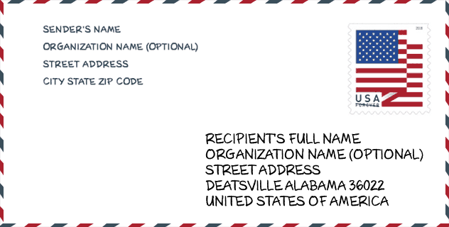
Envelope Example

This is an example of a US zip envelope. You can use a 5-digit zipcode or a detailed 9-digit zipcode to copy the mail in the following address format.
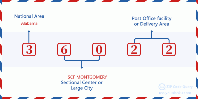
36022 Basic Meaning
What does each digit of ZIP Code 36022 stands for? The first digit designates a national area, which ranges from zero for the Northeast to nine for the far West. The 2-3 digits are the code of a sectional center facility in that region. The last two digits designate small post offices or postal zones.
Online Map

This is online map of the address Deatsville, Alabama, United States. You may use button to move and zoom in / out. The map information is for reference only.
University

This is the ZIP Code 36022 - University page list. Its detail university Name, Street, City, State, ZIP Code, Phone is as below.
| Name | Street | City | State | ZIP Code | Phone |
| J F Ingram State Technical College | 5375 Ingram Rd | Deatsville | AL | 36022 | (334) 285-5177 x3249 |
School
This is the ZIP Code 36022 - School page list. Its detail School Name, Address, City, State, ZIP Code is as below.
| School Name | Address | City | State | Grades | ZIP Code |
|---|---|---|---|---|---|
| JF Ingram State Technical College Special Services | 5375 Ingram Rd | Deatsville | AL | – | 36022 |
| Marbury High School | 2360 Highway 31 North | Deatsville | AL | 09-12 | 36022 |
| Pine Level Elementary School | 2040 Highway 31 N | Deatsville | AL | PK-05 | 36022 |
| Holtville High School | 10425 Holtville Rd | Deatsville | AL | 09-12 | 36022 |
| Holtville Middle School | 655 Bulldog Ln | Deatsville | AL | 05-08 | 36022 |
| Holtville Elementary School | 287 Whatley Rd | Deatsville | AL | PK-04 | 36022 |
Population for ZIP Code 36022

What is the total population in ZIP Code 36022? Below is detail information.
- Population for ZIP Code 36022: 14,891
- 2010 Population: 13,092
The 2020 demographic statistics are in progress. The current population in ZIP code 36022 is 14,891, and the population in 2010 is 13,092.
Gender

In all the statistical population, the male population is 5,994, the female population is 7,098.
- Male Population: 5,994
- Female Population: 7,098
Race

In all the statistical population, the male population is 5,994, the female population is 7,098.
- White Population: 11,596
- Black Population: 1,391
- Hispanic Population: 354
- Asian Population: 98
- Hawaiian Population: 11
- Indian Population: 144
- Other Population: 75
Age

In all the statistical population, the White population is 11,596, the Black population is 1,391, the Hispanic population is 354, the Asian population is 98, the Hawaiian population is 11, the Indian Ppopulation is 144 and Other population is 75.
- Age's Median: 37.4
- Median of male age: 37.0
- Median of female age: 37.6
Households for ZIP Code 36022
ZIP code 36022 has 4,161 households, with an average number of 2.74 persons per household. The average income per household in Zip code 36022 is 67,513 USD, and the average house value is 170,700 USD.
- Households Per Zipcode: 4,161
- Persons Per Household: 2.74
- Average House Value: 170,700
- Income Per Household: 67,513
Geographic

The latitude of the Zip code 36022 is 32.610801, the longitude is -86.420152, and the elevation is 388. It has land area of 90.677 square miles, and water area of 3.146 square miles. The time zone for ZIP code 36022 is Central (GMT -06:00). Daylight saving time should be observed in the area where the zip code is located.
- Latitude: 32.610801
- Longitude: -86.420152
- Elevation: 388
- Land Area: 90.677
- Water Area: 3.146
- Time Zone: Central (GMT -06:00)
- Region: South
- Division: East South Central
- Day Light Saving: Y
Congressional District

The Congressional District for ZIP code 36022 is Alabama's 2nd congressional district, the Congressional Land Area is 10141.63 square mile.
- Congressional District: 2nd
- Congressional Land Area: 10141.63
Delivery

In the ZIP code 36022, there are 5,435 residential delivery mailboxes and centralized units, and 64 commercial delivery mailbox and centralized units, 5,341 single family deliveries and 0 multifamily deliveries, and the box count is 5,608. The main post office does not have city delivery carrier routes for the ZIP code 36022.
- Delivery Residential: 5,435
- Delivery Business: 64
- Delivery Total: 5,608
- Single Family Delivery Units: 5,341
- Multi Family Delivery Units: 0
- City Delivery Indicator: N
Business

In ZIP code 36022, the number of business is 75, the number of employee is 325, the business first quarter payroll is 2,224,000 USD, the business annual payroll is 9,987,000 USD.
- Number Of Businesses: 75
- Number Of Employees: 325
- Business First Quarter Payroll: 2,224,000
- Business Annual Payroll: 9,987,000
Social Security Benefits

There are 2,765 beneficiaries with benefits in current-payment status for ZIP code 36022, of which 1,755 are retired workers, 515 are disabled workers, 155 are widow(er)s and parents, 80 are spouses and 260 are children. The number of beneficiaries aged 65 or older is 1,810. The total monthly benefits are 3,818,000 USD, of which 2,687,000 USD for retired workers, 199,000 USD for widow(er)s and parents.
- Total Number: 2,765
- Retired workers Number: 1,755
- Disabled workers Number: 515
- Widow(er)s and parents Number: 155
- Spouses Number: 80
- Children Number: 260
- All beneficiaries per month: 3,818,000
- Retired workers per month: 2,687,000
- Widow(er)s and parents per month: 199,000
- Number of beneficiaries aged 65 or older: 1,810


Add new comment