ZIP Code: 36092, Wetumpka, AL
ZIP Code 36092 is located in Wetumpka, Alabama. Its detail State, County, City, Longitude, Latitude, Envelope Example, Population is as below.
ZIP Code 36092 Information

-
-
Country:
U.S. - United States
State:
County FIPS:
01051
County:
City:
Area Code:
City Type ?In many cases, a ZIP Code can have multiple "names", meaning cities, towns, or subdivisions, in its boundaries. However, it will ALWAYS have exactly 1 "default" name. D - Default - This is the "preferred" name - by the USPS - for a city. Each ZIP Code has one - and only one - "default" name. In most cases, this is what people who live in that area call the city as well. A - Acceptable - This name can be used for mailing purposes. Often times alternative names are large neighborhoods or sections of the city/town. In some cases a ZIP Code may have several "acceptable" names which is used to group towns under one ZIP Code. N - Not Acceptable - A "not acceptable" name is, in many cases, a nickname that residents give that location. According to the USPS, you should NOT send mail to that ZIP Code using the "not acceptable" name when mailing.:
D (Default)
ZIP Code:
36092
❓What does D (Default) mean? This is the "preferred" name - by the USPS - for a city. Each ZIP Code has one - and only one - "default" name. In most cases, this is what people who live in that area call the city as well.
ZIP Code 36092 Plus 4
ZIP Code 5 plus 4 is the extension of 5-digit zip code, It can be used to locate a more detailed location. The last four digits designate segment or one side of a street or an apartment. You can find the ZIP+4 code and corresponding address of the zip code 36092 below.
| ZIP Code 5 Plus 4 | Address |
|---|---|
| 36092-0001 | PO BOX 1, WETUMPKA, AL |
| 36092-0002 | PO BOX 61, WETUMPKA, AL |
| 36092-0003 | PO BOX 121, WETUMPKA, AL |
| 36092-0004 | PO BOX 181, WETUMPKA, AL |
| 36092-0005 | PO BOX 241, WETUMPKA, AL |
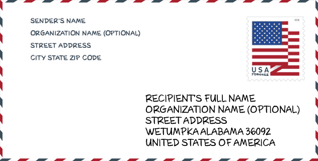
Envelope Example

This is an example of a US zip envelope. You can use a 5-digit zipcode or a detailed 9-digit zipcode to copy the mail in the following address format.
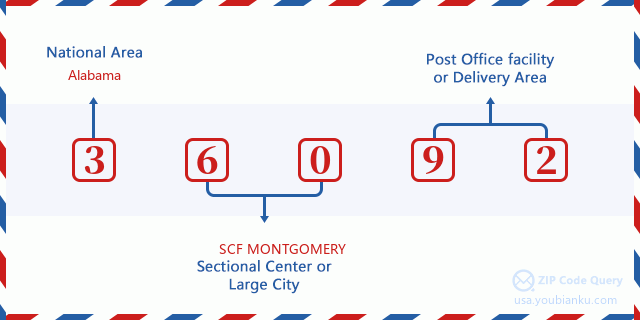
36092 Basic Meaning
What does each digit of ZIP Code 36092 stands for? The first digit designates a national area, which ranges from zero for the Northeast to nine for the far West. The 2-3 digits are the code of a sectional center facility in that region. The last two digits designate small post offices or postal zones.
Online Map

This is online map of the address Wetumpka, Alabama, United States. You may use button to move and zoom in / out. The map information is for reference only.
Hospital

This is the ZIP Code 36092 - Hospital page list. Its detail Hospital Name, Street, City, State, ZIP Code, Phone is as below.
- Name: ELMORE COMMUNITY HOSPITAL
- Address: WETUMPKA
- City: 500 HOSPITAL DRIVE
- State: AL
- ZIP Code: 36092
- Phone: (334) 567-4311
Museum

This is the ZIP Code 36092 - Museum page list. Its detail Museum Name, Street, City, State, ZIP Code, Phone is as below.
| Name | Street | City | State | ZIP Code | Phone |
| ALABAMA RIVER REGION ARTS CENTER | 300 W TALLASSEE ST | WETUMPKA | AL | 36092 | (334) 578-9485 |
| ELMORE COUNTY HISTORICAL SOCIETY | PO BOX 912 | WETUMPKA | AL | 36092 |
Library

This is the ZIP Code 36092 - Library page list. Its detail Library Name, Address, City, State, ZIP Code, Phone is as below.
- Name: WETUMPKA PUBLIC LIBRARY
- Address: 212 SOUTH MAIN STREET
- City: WETUMPKA
- State: AL - Alabama
- ZIP Code: 36092
- Phone: (334) 567-1308
School

This is the ZIP Code 36092 - School page list. Its detail School Name, Address, City, State, ZIP Code is as below.
| School Name | Address | City | State | Grades | ZIP Code |
|---|---|---|---|---|---|
| Tutwiler Prison | 8966 US Highway 231 | Wetumpka | AL | – | 36092 |
| Wetumpka Middle School | 1000 Micanopy St | Wetumpka | AL | 05-08 | 36092 |
| Wetumpka Elementary School | 510 Micanopy St | Wetumpka | AL | PK-04 | 36092 |
| Wetumpka High School | 1251 Coosa River Pkwy | Wetumpka | AL | 09-12 | 36092 |
| Elmore County Technical Center | 800 KellyFitzpatrick Dr | Wetumpka | AL | 10-12 | 36092 |
| EDGE Virtual School | 517 MICANOPY STREET | WEUMPKA | AL | 03-12 | 36092 |
Population for ZIP Code 36092

What is the total population in ZIP Code 36092? Below is detail information.
- Population for ZIP Code 36092: 21,719
- 2010 Population: 20,274
The 2020 demographic statistics are in progress. The current population in ZIP code 36092 is 21,719, and the population in 2010 is 20,274.
Gender

In all the statistical population, the male population is 9,251, the female population is 11,023.
- Male Population: 9,251
- Female Population: 11,023
Race

In all the statistical population, the male population is 9,251, the female population is 11,023.
- White Population: 15,245
- Black Population: 4,658
- Hispanic Population: 483
- Asian Population: 188
- Hawaiian Population: 30
- Indian Population: 195
- Other Population: 274
Age

In all the statistical population, the White population is 15,245, the Black population is 4,658, the Hispanic population is 483, the Asian population is 188, the Hawaiian population is 30, the Indian Ppopulation is 195 and Other population is 274.
- Age's Median: 37.6
- Median of male age: 36.6
- Median of female age: 38.2
Households for ZIP Code 36092
ZIP code 36092 has 7,378 households, with an average number of 2.59 persons per household. The average income per household in Zip code 36092 is 54,499 USD, and the average house value is 138,200 USD.
- Households Per Zipcode: 7,378
- Persons Per Household: 2.59
- Average House Value: 138,200
- Income Per Household: 54,499
Geographic

The latitude of the Zip code 36092 is 32.614290, the longitude is -86.201974, and the elevation is 322. It has land area of 130.775 square miles, and water area of 5.062 square miles. The time zone for ZIP code 36092 is Central (GMT -06:00). Daylight saving time should be observed in the area where the zip code is located.
- Latitude: 32.614290
- Longitude: -86.201974
- Elevation: 322
- Land Area: 130.775
- Water Area: 5.062
- Time Zone: Central (GMT -06:00)
- Region: South
- Division: East South Central
- Day Light Saving: Y
Congressional District

The Congressional District for ZIP code 36092 is Alabama's 2nd congressional district, the Congressional Land Area is 10141.63 square mile.
- Congressional District: 2nd
- Congressional Land Area: 10141.63
Delivery

In the ZIP code 36092, there are 8,386 residential delivery mailboxes and centralized units, and 505 commercial delivery mailbox and centralized units, 7,786 single family deliveries and 25 multifamily deliveries, and the box count is 9,656. The main post office has city delivery carrier routes for the ZIP code 36092.
- Delivery Residential: 8,386
- Delivery Business: 505
- Delivery Total: 9,656
- Single Family Delivery Units: 7,786
- Multi Family Delivery Units: 25
- City Delivery Indicator: Y
Business

In ZIP code 36092, the number of business is 357, the number of employee is 5,371, the business first quarter payroll is 40,675,000 USD, the business annual payroll is 161,928,000 USD.
- Number Of Businesses: 357
- Number Of Employees: 5,371
- Business First Quarter Payroll: 40,675,000
- Business Annual Payroll: 161,928,000
Social Security Benefits

There are 5,005 beneficiaries with benefits in current-payment status for ZIP code 36092, of which 3,160 are retired workers, 975 are disabled workers, 305 are widow(er)s and parents, 85 are spouses and 480 are children. The number of beneficiaries aged 65 or older is 3,305. The total monthly benefits are 6,509,000 USD, of which 4,525,000 USD for retired workers, 378,000 USD for widow(er)s and parents.
- Total Number: 5,005
- Retired workers Number: 3,160
- Disabled workers Number: 975
- Widow(er)s and parents Number: 305
- Spouses Number: 85
- Children Number: 480
- All beneficiaries per month: 6,509,000
- Retired workers per month: 4,525,000
- Widow(er)s and parents per month: 378,000
- Number of beneficiaries aged 65 or older: 3,305


Add new comment