ZIP Code: 36602, Mobile, AL
ZIP Code 36602 is located in Mobile, Alabama. Its detail State, County, City, Longitude, Latitude, Envelope Example, Population is as below.
ZIP Code 36602 Information

-
-
Country:
U.S. - United States
State:
County FIPS:
01097
County:
City:
Area Code:
City Type ?In many cases, a ZIP Code can have multiple "names", meaning cities, towns, or subdivisions, in its boundaries. However, it will ALWAYS have exactly 1 "default" name. D - Default - This is the "preferred" name - by the USPS - for a city. Each ZIP Code has one - and only one - "default" name. In most cases, this is what people who live in that area call the city as well. A - Acceptable - This name can be used for mailing purposes. Often times alternative names are large neighborhoods or sections of the city/town. In some cases a ZIP Code may have several "acceptable" names which is used to group towns under one ZIP Code. N - Not Acceptable - A "not acceptable" name is, in many cases, a nickname that residents give that location. According to the USPS, you should NOT send mail to that ZIP Code using the "not acceptable" name when mailing.:
D (Default)
ZIP Code:
36602
❓What does D (Default) mean? This is the "preferred" name - by the USPS - for a city. Each ZIP Code has one - and only one - "default" name. In most cases, this is what people who live in that area call the city as well.
ZIP Code 36602 Plus 4
ZIP Code 5 plus 4 is the extension of 5-digit zip code, It can be used to locate a more detailed location. The last four digits designate segment or one side of a street or an apartment. You can find the ZIP+4 code and corresponding address of the zip code 36602 below.
| ZIP Code 5 Plus 4 | Address |
|---|---|
| 36602-1100 | 110 S BROAD ST, MOBILE, AL |
| 36602-1101 | 801 GOVERNMENT ST, MOBILE, AL |
| 36602-1102 | 800 GOVERNMENT ST, MOBILE, AL |
| 36602-1103 | 851 GOVERNMENT ST, MOBILE, AL |
| 36602-1104 | 850 GOVERNMENT ST, MOBILE, AL |
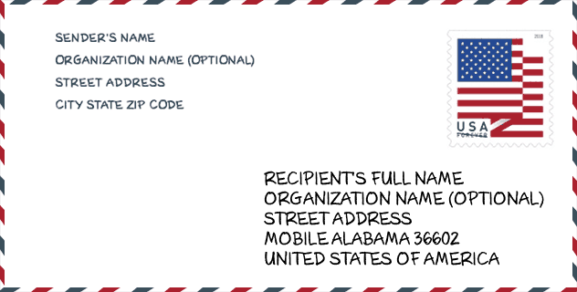
Envelope Example

This is an example of a US zip envelope. You can use a 5-digit zipcode or a detailed 9-digit zipcode to copy the mail in the following address format.
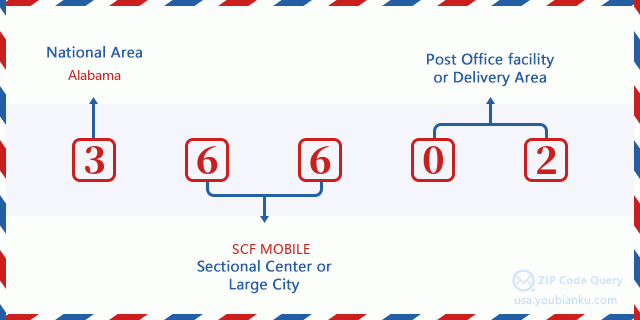
36602 Basic Meaning
What does each digit of ZIP Code 36602 stands for? The first digit designates a national area, which ranges from zero for the Northeast to nine for the far West. The 2-3 digits are the code of a sectional center facility in that region. The last two digits designate small post offices or postal zones.
Online Map

This is online map of the address Mobile, Alabama, United States. You may use button to move and zoom in / out. The map information is for reference only.
Museum

This is the ZIP Code 36602 - Museum page list. Its detail Museum Name, Street, City, State, ZIP Code, Phone is as below.
| Name | Street | City | State | ZIP Code | Phone |
| PHOENIX FIRE MUSEUM | 203 S CLAIBORNE ST | MOBILE | AL | 36602 | (251) 208-7569 |
| NATIONAL MARITIME MUSEUM | 250 N WATER ST | MOBILE | AL | 36602 | (251) 436-8901 |
| GULFQUEST | PO BOX 3005 | MOBILE | AL | 36602 |
Library

This is the ZIP Code 36602 - Library page list. Its detail Library Name, Address, City, State, ZIP Code, Phone is as below.
| Name | Address | City | State | ZIP Code | Phone |
|---|---|---|---|---|---|
| MOBILE PUBLIC - PARKWAY BRANCH | 1924-B DAUPHIN ISLAND PARKWAY | MOBILE | AL | 36602 | (251) 470-7766 |
| MOBILE PUBLIC - THEODORE OAKS BRANCH | 5808 HIGHWAY 90 WEST, SUITE E | MOBILE | AL | 36602 | (251) 653-5417 |
| MOBILE PUBLIC - TOULMINVILLE BRANCH | 601 STANTON ROAD | MOBILE | AL | 36602 | (251) 438-7075 |
| MOBILE PUBLIC - TRINITY GARDENS COMMUNITY BRANCH LIBRARY | 2668 BERKLEY AVENUE | MOBILE | AL | 36602 | (251) 457-5954 |
| MOBILE PUBLIC - WEST REGIONAL LIBRARY | 5555 GRELOT ROAD | MOBILE | AL | 36602 | (251) 340-8550 |
| MOBILE PUBLIC LIBRARY | 701 GOVERNMENT STREET | MOBILE | AL | 36602 | (251) 208-7073 |
| MOBILE PUBLIC LIBRARY - BEN MAY MAIN LIBRARY | 701 GOVERNMENT STREET | MOBILE | AL | 36602 | (251) 208-7073 |
| SEMMES BRANCH | 9150 MOFFETT ROAD | MOBILE | AL | 36602 | (251) 645-6840 |
School

This is the ZIP Code 36602 - School page list. Its detail School Name, Address, City, State, ZIP Code is as below.
- School Name: Barton Academy For Advanced World Studies
- Address: 504 Government Street
- City: Mobile
- State: AL
- Grades: 06-09
- ZIP Code: 36602
Population for ZIP Code 36602

What is the total population in ZIP Code 36602? Below is detail information.
- Population for ZIP Code 36602: 1,053
- 2010 Population: 1,057
The 2020 demographic statistics are in progress. The current population in ZIP code 36602 is 1,053, and the population in 2010 is 1,057.
Gender

In all the statistical population, the male population is 618, the female population is 439.
- Male Population: 618
- Female Population: 439
Race

In all the statistical population, the male population is 618, the female population is 439.
- White Population: 601
- Black Population: 441
- Hispanic Population: 25
- Asian Population: 12
- Hawaiian Population: 2
- Indian Population: 14
- Other Population: 5
Age

In all the statistical population, the White population is 601, the Black population is 441, the Hispanic population is 25, the Asian population is 12, the Hawaiian population is 2, the Indian Ppopulation is 14 and Other population is 5.
- Age's Median: 49.2
- Median of male age: 47.9
- Median of female age: 52.5
Households for ZIP Code 36602
ZIP code 36602 has 540 households, with an average number of 1.39 persons per household. The average income per household in Zip code 36602 is 23,958 USD, and the average house value is 194,000 USD.
- Households Per Zipcode: 540
- Persons Per Household: 1.39
- Average House Value: 194,000
- Income Per Household: 23,958
Geographic

The latitude of the Zip code 36602 is 30.688342, the longitude is -88.033005, and the elevation is 3. It has land area of 0.912 square miles, and water area of 0 square miles. The time zone for ZIP code 36602 is Central (GMT -06:00). Daylight saving time should be observed in the area where the zip code is located.
- Latitude: 30.688342
- Longitude: -88.033005
- Elevation: 3
- Land Area: 0.912
- Water Area: 0
- Time Zone: Central (GMT -06:00)
- Region: South
- Division: East South Central
- Day Light Saving: Y
Congressional District

The Congressional District for ZIP code 36602 is Alabama's 1st congressional district, the Congressional Land Area is 6066.83 square mile.
- Congressional District: 1st
- Congressional Land Area: 6066.83
Delivery

In the ZIP code 36602, there are 758 residential delivery mailboxes and centralized units, and 729 commercial delivery mailbox and centralized units, 238 single family deliveries and 494 multifamily deliveries, and the box count is 1,482. The main post office has city delivery carrier routes for the ZIP code 36602.
- Delivery Residential: 758
- Delivery Business: 729
- Delivery Total: 1,482
- Single Family Delivery Units: 238
- Multi Family Delivery Units: 494
- City Delivery Indicator: Y
Business

In ZIP code 36602, the number of business is 550, the number of employee is 15,076, the business first quarter payroll is 211,411,000 USD, the business annual payroll is 849,429,000 USD.
- Number Of Businesses: 550
- Number Of Employees: 15,076
- Business First Quarter Payroll: 211,411,000
- Business Annual Payroll: 849,429,000
Social Security Benefits

There are 345 beneficiaries with benefits in current-payment status for ZIP code 36602, of which 265 are retired workers, 35 are disabled workers, 20 are widow(er)s and parents, 5 are spouses and 20 are children. The number of beneficiaries aged 65 or older is 285. The total monthly benefits are 416,000 USD, of which 333,000 USD for retired workers, 27,000 USD for widow(er)s and parents.
- Total Number: 345
- Retired workers Number: 265
- Disabled workers Number: 35
- Widow(er)s and parents Number: 20
- Spouses Number: 5
- Children Number: 20
- All beneficiaries per month: 416,000
- Retired workers per month: 333,000
- Widow(er)s and parents per month: 27,000
- Number of beneficiaries aged 65 or older: 285


Add new comment