United States ZIP Code: 50707
This is the Iowa ZIP Code 50707 page list. Its detail State, County, City, Longitude, Latitude, Envelope Example, Population is as below.
ZIP Code 50707 Information

ZIP Code 50707 - City

This is the city information corresponding to 50707:
| State | County | City | City Type ?In many cases, a ZIP Code can have multiple "names", meaning cities, towns, or subdivisions, in its boundaries. However, it will ALWAYS have exactly 1 "default" name. D - Default - This is the "preferred" name - by the USPS - for a city. Each ZIP Code has one - and only one - "default" name. In most cases, this is what people who live in that area call the city as well. A - Acceptable - This name can be used for mailing purposes. Often times alternative names are large neighborhoods or sections of the city/town. In some cases a ZIP Code may have several "acceptable" names which is used to group towns under one ZIP Code. N - Not Acceptable - A "not acceptable" name is, in many cases, a nickname that residents give that location. According to the USPS, you should NOT send mail to that ZIP Code using the "not acceptable" name when mailing. | ZIP Code |
|---|---|---|---|---|
| IA | Black Hawk | Elk Run Heights | A (Acceptable) | 50707 |
| IA | Black Hawk | Elk Run Hgts | A (Acceptable) | 50707 |
| IA | Black Hawk | Evansdale | D (Default) | 50707 |
| IA | Black Hawk | Raymar | N (Not Acceptable) | 50707 |
| IA | Black Hawk | Waterloo | A (Acceptable) | 50707 |
❓What does D (Default) mean? This is the "preferred" name - by the USPS - for a city. Each ZIP Code has one - and only one - "default" name. In most cases, this is what people who live in that area call the city as well.
❓What does A (Acceptable) mean? This name can be used for mailing purposes. Often times alternative names are large neighborhoods or sections of the city/town. In some cases a ZIP Code may have several "acceptable" names which is used to group towns under one ZIP Code.
❓What does N (Not Acceptable) mean? A "not acceptable" name is, in many cases, a nickname that residents give that location. According to the USPS, you should NOT send mail to that ZIP Code using the "not acceptable" name when mailing.
ZIP Code 50707 Plus 4
ZIP Code 5 plus 4 is the extension of 5-digit zip code, It can be used to locate a more detailed location. The last four digits designate segment or one side of a street or an apartment. You can find the ZIP+4 code and corresponding address of the zip code 50707 below.
| ZIP Code 5 Plus 4 | Address |
|---|---|
| 50707-0001 | PO BOX 3001, EVANSDALE, IA |
| 50707-0008 | PO BOX 3600, EVANSDALE, IA |
| 50707-1000 | 101 AMBER AVE, EVANSDALE, IA |
| 50707-1001 | 101 BROVAN BLVD, EVANSDALE, IA |
| 50707-1002 | 100 BROVAN BLVD, EVANSDALE, IA |
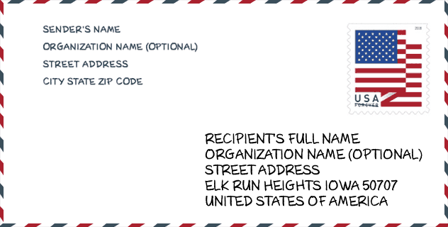
Envelope Example

This is an example of a US zip envelope. You can use a 5-digit zipcode or a detailed 9-digit zipcode to copy the mail in the following address format.
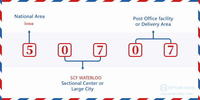
50707 Basic Meaning
What does each digit of ZIP Code 50707 stands for? The first digit designates a national area, which ranges from zero for the Northeast to nine for the far West. The 2-3 digits are the code of a sectional center facility in that region. The last two digits designate small post offices or postal zones.
Online Map

This is online map of the address Waterloo, Iowa, United States. You may use button to move and zoom in / out. The map information is for reference only.
Museum

This is the ZIP Code 50707 - Museum page list. Its detail Museum Name, Street, City, State, ZIP Code, Phone is as below.
- Name: GROUT MUSEUM
- Street: 520 3RD ST
- City: WATERLOO
- State: IA
- ZIP Code: 50707
- Phone: (319) 234-6357
Library

This is the ZIP Code 50707 - Library page list. Its detail Library Name, Address, City, State, ZIP Code, Phone is as below.
- Name: EVANSDALE PUBLIC LIBRARY
- Address: 123 N EVANS RD
- City: EVANSDALE
- State: IA - Iowa
- ZIP Code: 50707
- Phone: (319) 232-5367
School

This is the ZIP Code 50707 - School page list. Its detail School Name, Address, City, State, ZIP Code is as below.
| School Name | Address | City | State | Grades | ZIP Code |
|---|---|---|---|---|---|
| Bunger Middle School | 157 S Roosevelt Rd | Evansdale | IA | UG | 50707 |
| Poyner Elementary | 1138 Central Ave | Evansdale | IA | UG | 50707 |
| Elk Run Early Childhood Center | 316 MC COY RD | Elk Run Heights | IA | UG | 50707 |
Population for ZIP Code 50707

What is the total population in ZIP Code 50707? Below is detail information.
- Population for ZIP Code 50707: 8,702
- 2010 Population: 8,509
The 2020 demographic statistics are in progress. The current population in ZIP code 50707 is 8,702, and the population in 2010 is 8,509.
Gender

In all the statistical population, the male population is 4,205, the female population is 4,304.
- Male Population: 4,205
- Female Population: 4,304
Race

In all the statistical population, the male population is 4,205, the female population is 4,304.
- White Population: 7,617
- Black Population: 748
- Hispanic Population: 452
- Asian Population: 93
- Hawaiian Population: 30
- Indian Population: 87
- Other Population: 232
Age

In all the statistical population, the White population is 7,617, the Black population is 748, the Hispanic population is 452, the Asian population is 93, the Hawaiian population is 30, the Indian Ppopulation is 87 and Other population is 232.
- Age's Median: 37.7
- Median of male age: 37.3
- Median of female age: 38.0
Households for ZIP Code 50707
ZIP code 50707 has 3,432 households, with an average number of 2.48 persons per household. The average income per household in Zip code 50707 is 49,223 USD, and the average house value is 108,700 USD.
- Households Per Zipcode: 3,432
- Persons Per Household: 2.48
- Average House Value: 108,700
- Income Per Household: 49,223
Geographic

The latitude of the Zip code 50707 is 42.480690, the longitude is -92.270795, and the elevation is 851. It has land area of 9.67 square miles, and water area of 0.134 square miles. The time zone for ZIP code 50707 is Central (GMT -06:00). Daylight saving time should be observed in the area where the zip code is located.
- Latitude: 42.480690
- Longitude: -92.270795
- Elevation: 851
- Land Area: 9.67
- Water Area: 0.134
- Time Zone: Central (GMT -06:00)
- Region: Midwest
- Division: West North Central
- Day Light Saving: Y
Congressional District

The Congressional District for ZIP code 50707 is Iowa's 1st congressional district, the Congressional Land Area is 12048.84 square mile.
- Congressional District: 1st
- Congressional Land Area: 12048.84
Delivery

In the ZIP code 50707, there are 3,509 residential delivery mailboxes and centralized units, and 144 commercial delivery mailbox and centralized units, 3,133 single family deliveries and 162 multifamily deliveries, and the box count is 3,653. The main post office has city delivery carrier routes for the ZIP code 50707.
- Delivery Residential: 3,509
- Delivery Business: 144
- Delivery Total: 3,653
- Single Family Delivery Units: 3,133
- Multi Family Delivery Units: 162
- City Delivery Indicator: Y
Business

In ZIP code 50707, the number of business is 106, the number of employee is 1,032, the business first quarter payroll is 8,066,000 USD, the business annual payroll is 34,723,000 USD.
- Number Of Businesses: 106
- Number Of Employees: 1,032
- Business First Quarter Payroll: 8,066,000
- Business Annual Payroll: 34,723,000
Social Security Benefits

There are 1,980 beneficiaries with benefits in current-payment status for ZIP code 50707, of which 1,325 are retired workers, 345 are disabled workers, 150 are widow(er)s and parents, 50 are spouses and 110 are children. The number of beneficiaries aged 65 or older is 1,410. The total monthly benefits are 2,637,000 USD, of which 1,947,000 USD for retired workers, 202,000 USD for widow(er)s and parents.
- Total Number: 1,980
- Retired workers Number: 1,325
- Disabled workers Number: 345
- Widow(er)s and parents Number: 150
- Spouses Number: 50
- Children Number: 110
- All beneficiaries per month: 2,637,000
- Retired workers per month: 1,947,000
- Widow(er)s and parents per month: 202,000
- Number of beneficiaries aged 65 or older: 1,410


Add new comment