United States ZIP Code: 51334
This is the Iowa ZIP Code 51334 page list. Its detail State, County, City, Longitude, Latitude, Envelope Example, Population is as below.
ZIP Code 51334 Information

ZIP Code 51334 - City

This is the city information corresponding to 51334:
| State | County | City | City Type ?In many cases, a ZIP Code can have multiple "names", meaning cities, towns, or subdivisions, in its boundaries. However, it will ALWAYS have exactly 1 "default" name. D - Default - This is the "preferred" name - by the USPS - for a city. Each ZIP Code has one - and only one - "default" name. In most cases, this is what people who live in that area call the city as well. A - Acceptable - This name can be used for mailing purposes. Often times alternative names are large neighborhoods or sections of the city/town. In some cases a ZIP Code may have several "acceptable" names which is used to group towns under one ZIP Code. N - Not Acceptable - A "not acceptable" name is, in many cases, a nickname that residents give that location. According to the USPS, you should NOT send mail to that ZIP Code using the "not acceptable" name when mailing. | ZIP Code |
|---|---|---|---|---|
| IA | Emmet | Estherville | D (Default) | 51334 |
| IA | Emmet | Gruver | A (Acceptable) | 51334 |
❓What does D (Default) mean? This is the "preferred" name - by the USPS - for a city. Each ZIP Code has one - and only one - "default" name. In most cases, this is what people who live in that area call the city as well.
❓What does A (Acceptable) mean? This name can be used for mailing purposes. Often times alternative names are large neighborhoods or sections of the city/town. In some cases a ZIP Code may have several "acceptable" names which is used to group towns under one ZIP Code.
ZIP Code 51334 Plus 4
ZIP Code 5 plus 4 is the extension of 5-digit zip code, It can be used to locate a more detailed location. The last four digits designate segment or one side of a street or an apartment. You can find the ZIP+4 code and corresponding address of the zip code 51334 below.
| ZIP Code 5 Plus 4 | Address |
|---|---|
| 51334-0001 | PO BOX 1, ESTHERVILLE, IA |
| 51334-1000 | 301 KNOLLWOOD DR, ESTHERVILLE, IA |
| 51334-1001 | 2021 N 6TH ST, ESTHERVILLE, IA |
| 51334-1002 | 2014 N 6TH ST, ESTHERVILLE, IA |
| 51334-1003 | 2103 N 6TH ST, ESTHERVILLE, IA |
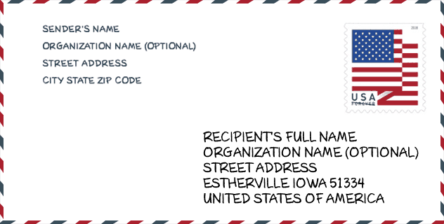
Envelope Example

This is an example of a US zip envelope. You can use a 5-digit zipcode or a detailed 9-digit zipcode to copy the mail in the following address format.
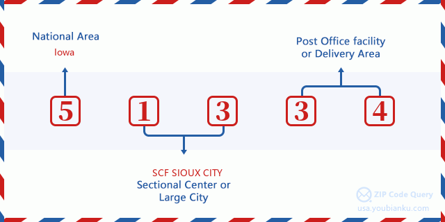
51334 Basic Meaning
What does each digit of ZIP Code 51334 stands for? The first digit designates a national area, which ranges from zero for the Northeast to nine for the far West. The 2-3 digits are the code of a sectional center facility in that region. The last two digits designate small post offices or postal zones.
Online Map

This is online map of the address Gruver, Iowa, United States. You may use button to move and zoom in / out. The map information is for reference only.
Hospital

This is the ZIP Code 51334 - Hospital page list. Its detail Hospital Name, Street, City, State, ZIP Code, Phone is as below.
- Name: AVERA HOLY FAMILY HOSPITAL
- Address: ESTHERVILLE
- City: 826 NORTH 8TH STREET
- State: IA
- ZIP Code: 51334
- Phone: (712) 362-2631
Museum

This is the ZIP Code 51334 - Museum page list. Its detail Museum Name, Street, City, State, ZIP Code, Phone is as below.
- Name: EMMET COUNTY HISTORICAL SOCIETY
- Street: 1720 3RD AVENUE SOUTH
- City: ESTHERVILLE
- State: IA
- ZIP Code: 51334
- Phone:
Library

This is the ZIP Code 51334 - Library page list. Its detail Library Name, Address, City, State, ZIP Code, Phone is as below.
- Name: ESTHERVILLE PUBLIC LIBRARY
- Address: 613 CENTRAL AVE
- City: ESTHERVILLE
- State: IA - Iowa
- ZIP Code: 51334
- Phone: (712) 362-7731
School

This is the ZIP Code 51334 - School page list. Its detail School Name, Address, City, State, ZIP Code is as below.
| School Name | Address | City | State | Grades | ZIP Code |
|---|---|---|---|---|---|
| Demoney Elementary | 109 S 17TH STREET | Estherville | IA | UG | 51334 |
| Estherville Lincoln Central High School | 1520 Central Ave | Estherville | IA | UG | 51334 |
| Estherville Lincoln Central Middle School | 1430 1ST AVE. S. | Estherville | IA | UG | 51334 |
Population for ZIP Code 51334

What is the total population in ZIP Code 51334? Below is detail information.
- Population for ZIP Code 51334: 7,080
- 2010 Population: 7,661
The 2020 demographic statistics are in progress. The current population in ZIP code 51334 is 7,080, and the population in 2010 is 7,661.
Gender

In all the statistical population, the male population is 3,882, the female population is 3,779.
- Male Population: 3,882
- Female Population: 3,779
Race

In all the statistical population, the male population is 3,882, the female population is 3,779.
- White Population: 7,146
- Black Population: 82
- Hispanic Population: 721
- Asian Population: 61
- Hawaiian Population: 4
- Indian Population: 80
- Other Population: 428
Age

In all the statistical population, the White population is 7,146, the Black population is 82, the Hispanic population is 721, the Asian population is 61, the Hawaiian population is 4, the Indian Ppopulation is 80 and Other population is 428.
- Age's Median: 39.3
- Median of male age: 36.0
- Median of female age: 42.7
Households for ZIP Code 51334
ZIP code 51334 has 3,130 households, with an average number of 2.32 persons per household. The average income per household in Zip code 51334 is 51,549 USD, and the average house value is 91,300 USD.
- Households Per Zipcode: 3,130
- Persons Per Household: 2.32
- Average House Value: 91,300
- Income Per Household: 51,549
Geographic

The latitude of the Zip code 51334 is 43.377997, the longitude is -94.769030, and the elevation is 1317. It has land area of 187.393 square miles, and water area of 2.476 square miles. The time zone for ZIP code 51334 is Central (GMT -06:00). Daylight saving time should be observed in the area where the zip code is located.
- Latitude: 43.377997
- Longitude: -94.769030
- Elevation: 1317
- Land Area: 187.393
- Water Area: 2.476
- Time Zone: Central (GMT -06:00)
- Region: Midwest
- Division: West North Central
- Day Light Saving: Y
Congressional District

The Congressional District for ZIP code 51334 is Iowa's 04th congressional district, the Congressional Land Area is 22756.75 square mile.
- Congressional District: 04th
- Congressional Land Area: 22756.75
Delivery

In the ZIP code 51334, there are 3,052 residential delivery mailboxes and centralized units, and 213 commercial delivery mailbox and centralized units, 2,654 single family deliveries and 205 multifamily deliveries, and the box count is 3,406. The main post office has city delivery carrier routes for the ZIP code 51334.
- Delivery Residential: 3,052
- Delivery Business: 213
- Delivery Total: 3,406
- Single Family Delivery Units: 2,654
- Multi Family Delivery Units: 205
- City Delivery Indicator: Y
Business

In ZIP code 51334, the number of business is 227, the number of employee is 2,023, the business first quarter payroll is 15,359,000 USD, the business annual payroll is 67,001,000 USD.
- Number Of Businesses: 227
- Number Of Employees: 2,023
- Business First Quarter Payroll: 15,359,000
- Business Annual Payroll: 67,001,000
Social Security Benefits

There are 1,695 beneficiaries with benefits in current-payment status for ZIP code 51334, of which 1,260 are retired workers, 180 are disabled workers, 120 are widow(er)s and parents, 50 are spouses and 85 are children. The number of beneficiaries aged 65 or older is 1,380. The total monthly benefits are 2,254,000 USD, of which 1,784,000 USD for retired workers, 163,000 USD for widow(er)s and parents.
- Total Number: 1,695
- Retired workers Number: 1,260
- Disabled workers Number: 180
- Widow(er)s and parents Number: 120
- Spouses Number: 50
- Children Number: 85
- All beneficiaries per month: 2,254,000
- Retired workers per month: 1,784,000
- Widow(er)s and parents per month: 163,000
- Number of beneficiaries aged 65 or older: 1,380


Add new comment