United States ZIP Code: 52002
This is the Iowa ZIP Code 52002 page list. Its detail State, County, City, Longitude, Latitude, Envelope Example, Population is as below.
ZIP Code 52002 Information

ZIP Code 52002 - City

This is the city information corresponding to 52002:
| State | County | City | City Type ?In many cases, a ZIP Code can have multiple "names", meaning cities, towns, or subdivisions, in its boundaries. However, it will ALWAYS have exactly 1 "default" name. D - Default - This is the "preferred" name - by the USPS - for a city. Each ZIP Code has one - and only one - "default" name. In most cases, this is what people who live in that area call the city as well. A - Acceptable - This name can be used for mailing purposes. Often times alternative names are large neighborhoods or sections of the city/town. In some cases a ZIP Code may have several "acceptable" names which is used to group towns under one ZIP Code. N - Not Acceptable - A "not acceptable" name is, in many cases, a nickname that residents give that location. According to the USPS, you should NOT send mail to that ZIP Code using the "not acceptable" name when mailing. | ZIP Code |
|---|---|---|---|---|
| IA | Dubuque | Asbury | A (Acceptable) | 52002 |
| IA | Dubuque | Dubuque | D (Default) | 52002 |
❓What does D (Default) mean? This is the "preferred" name - by the USPS - for a city. Each ZIP Code has one - and only one - "default" name. In most cases, this is what people who live in that area call the city as well.
❓What does A (Acceptable) mean? This name can be used for mailing purposes. Often times alternative names are large neighborhoods or sections of the city/town. In some cases a ZIP Code may have several "acceptable" names which is used to group towns under one ZIP Code.
ZIP Code 52002 Plus 4
ZIP Code 5 plus 4 is the extension of 5-digit zip code, It can be used to locate a more detailed location. The last four digits designate segment or one side of a street or an apartment. You can find the ZIP+4 code and corresponding address of the zip code 52002 below.
| ZIP Code 5 Plus 4 | Address |
|---|---|
| 52002-0100 | 12481 JOHN F KENNEDY RD, DUBUQUE, IA |
| 52002-0101 | 12606 JOHN F KENNEDY RD, DUBUQUE, IA |
| 52002-0102 | 12486 JOHN F KENNEDY RD, DUBUQUE, IA |
| 52002-0119 | 12533 JOHN F KENNEDY RD, DUBUQUE, IA |
| 52002-0119 | 12567 JOHN F KENNEDY RD, DUBUQUE, IA |
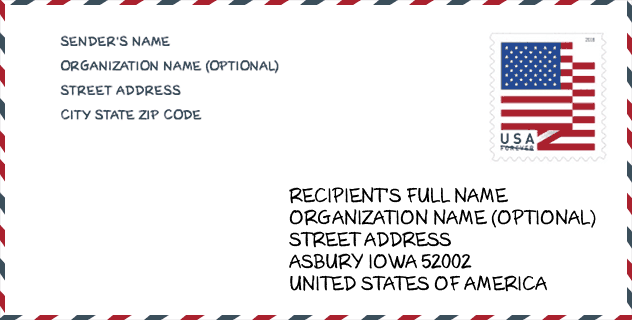
Envelope Example

This is an example of a US zip envelope. You can use a 5-digit zipcode or a detailed 9-digit zipcode to copy the mail in the following address format.
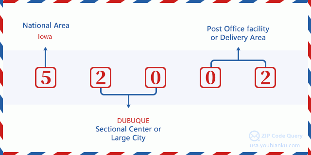
52002 Basic Meaning
What does each digit of ZIP Code 52002 stands for? The first digit designates a national area, which ranges from zero for the Northeast to nine for the far West. The 2-3 digits are the code of a sectional center facility in that region. The last two digits designate small post offices or postal zones.
Online Map

This is online map of the address Dubuque, Iowa, United States. You may use button to move and zoom in / out. The map information is for reference only.
Library

This is the ZIP Code 52002 - Library page list. Its detail Library Name, Address, City, State, ZIP Code, Phone is as below.
- Name: DUBUQUE COUNTY LIBRARY
- Address: 5290 GRAND MEADOW DR
- City: ASBURY
- State: IA - Iowa
- ZIP Code: 52002
- Phone: (563) 582-0008
School

This is the ZIP Code 52002 - School page list. Its detail School Name, Address, City, State, ZIP Code is as below.
| School Name | Address | City | State | Grades | ZIP Code |
|---|---|---|---|---|---|
| Hempstead High School | 3715 Pennsylvania Ave | Dubuque | IA | UG | 52002 |
| John Kennedy Elementary School | 2135 WOODLAND | Dubuque | IA | UG | 52002 |
| Sageville Elementary School | 12015 Sherrill Rd | Dubuque | IA | UG | 52002 |
| Eleanor Roosevelt Middle School | 2001 Radford Rd | Dubuque | IA | UG | 52002 |
| Carver Elementary School | 2007 RADFORD ROAD | Dubuque | IA | UG | 52002 |
Population for ZIP Code 52002

What is the total population in ZIP Code 52002? Below is detail information.
- Population for ZIP Code 52002: 17,997
- 2010 Population: 14,559
The 2020 demographic statistics are in progress. The current population in ZIP code 52002 is 17,997, and the population in 2010 is 14,559.
Gender

In all the statistical population, the male population is 7,146, the female population is 7,413.
- Male Population: 7,146
- Female Population: 7,413
Race

In all the statistical population, the male population is 7,146, the female population is 7,413.
- White Population: 13,984
- Black Population: 238
- Hispanic Population: 210
- Asian Population: 350
- Hawaiian Population: 13
- Indian Population: 38
- Other Population: 76
Age

In all the statistical population, the White population is 13,984, the Black population is 238, the Hispanic population is 210, the Asian population is 350, the Hawaiian population is 13, the Indian Ppopulation is 38 and Other population is 76.
- Age's Median: 39.2
- Median of male age: 38.0
- Median of female age: 40.4
Households for ZIP Code 52002
ZIP code 52002 has 5,603 households, with an average number of 2.57 persons per household. The average income per household in Zip code 52002 is 72,607 USD, and the average house value is 210,800 USD.
- Households Per Zipcode: 5,603
- Persons Per Household: 2.57
- Average House Value: 210,800
- Income Per Household: 72,607
Geographic

The latitude of the Zip code 52002 is 42.526799, the longitude is -90.790116, and the elevation is 820. It has land area of 28.837 square miles, and water area of 0 square miles. The time zone for ZIP code 52002 is Central (GMT -06:00). Daylight saving time should be observed in the area where the zip code is located.
- Latitude: 42.526799
- Longitude: -90.790116
- Elevation: 820
- Land Area: 28.837
- Water Area: 0
- Time Zone: Central (GMT -06:00)
- Region: Midwest
- Division: West North Central
- Day Light Saving: Y
Congressional District

The Congressional District for ZIP code 52002 is Iowa's 1st congressional district, the Congressional Land Area is 12048.84 square mile.
- Congressional District: 1st
- Congressional Land Area: 12048.84
Delivery

In the ZIP code 52002, there are 7,003 residential delivery mailboxes and centralized units, and 622 commercial delivery mailbox and centralized units, 4,018 single family deliveries and 1,220 multifamily deliveries, and the box count is 8,288. The main post office has city delivery carrier routes for the ZIP code 52002.
- Delivery Residential: 7,003
- Delivery Business: 622
- Delivery Total: 8,288
- Single Family Delivery Units: 4,018
- Multi Family Delivery Units: 1,220
- City Delivery Indicator: Y
Business

In ZIP code 52002, the number of business is 594, the number of employee is 11,613, the business first quarter payroll is 105,232,000 USD, the business annual payroll is 442,158,000 USD.
- Number Of Businesses: 594
- Number Of Employees: 11,613
- Business First Quarter Payroll: 105,232,000
- Business Annual Payroll: 442,158,000
Social Security Benefits

There are 3,830 beneficiaries with benefits in current-payment status for ZIP code 52002, of which 2,945 are retired workers, 315 are disabled workers, 250 are widow(er)s and parents, 110 are spouses and 210 are children. The number of beneficiaries aged 65 or older is 3,175. The total monthly benefits are 5,753,000 USD, of which 4,722,000 USD for retired workers, 394,000 USD for widow(er)s and parents.
- Total Number: 3,830
- Retired workers Number: 2,945
- Disabled workers Number: 315
- Widow(er)s and parents Number: 250
- Spouses Number: 110
- Children Number: 210
- All beneficiaries per month: 5,753,000
- Retired workers per month: 4,722,000
- Widow(er)s and parents per month: 394,000
- Number of beneficiaries aged 65 or older: 3,175


Add new comment