ZIP Code: 52601, Burlington, IA
ZIP Code 52601 is located in Burlington, Iowa. Its detail State, County, City, Longitude, Latitude, Envelope Example, Population is as below.
ZIP Code 52601 Information

-
-
Country:
U.S. - United States
State:
County FIPS:
19057
City:
Area Code:
City Type ?In many cases, a ZIP Code can have multiple "names", meaning cities, towns, or subdivisions, in its boundaries. However, it will ALWAYS have exactly 1 "default" name. D - Default - This is the "preferred" name - by the USPS - for a city. Each ZIP Code has one - and only one - "default" name. In most cases, this is what people who live in that area call the city as well. A - Acceptable - This name can be used for mailing purposes. Often times alternative names are large neighborhoods or sections of the city/town. In some cases a ZIP Code may have several "acceptable" names which is used to group towns under one ZIP Code. N - Not Acceptable - A "not acceptable" name is, in many cases, a nickname that residents give that location. According to the USPS, you should NOT send mail to that ZIP Code using the "not acceptable" name when mailing.:
D (Default)
ZIP Code:
52601
❓What does D (Default) mean? This is the "preferred" name - by the USPS - for a city. Each ZIP Code has one - and only one - "default" name. In most cases, this is what people who live in that area call the city as well.
ZIP Code 52601 Plus 4
ZIP Code 5 plus 4 is the extension of 5-digit zip code, It can be used to locate a more detailed location. The last four digits designate segment or one side of a street or an apartment. You can find the ZIP+4 code and corresponding address of the zip code 52601 below.
| ZIP Code 5 Plus 4 | Address |
|---|---|
| 52601-0001 | PO BOX 1, BURLINGTON, IA |
| 52601-0121 | PO BOX 121, BURLINGTON, IA |
| 52601-0241 | PO BOX 241, BURLINGTON, IA |
| 52601-0361 | PO BOX 361, BURLINGTON, IA |
| 52601-0481 | PO BOX 481, BURLINGTON, IA |
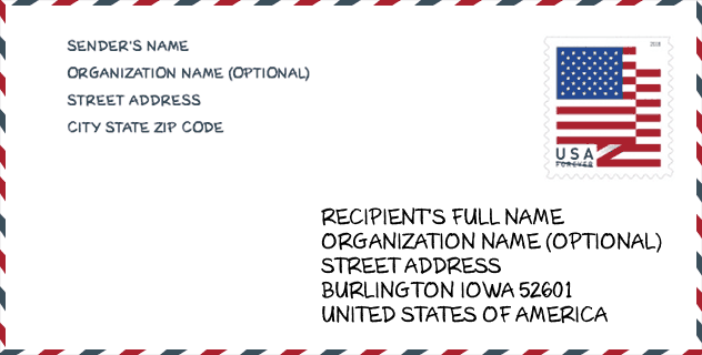
Envelope Example

This is an example of a US zip envelope. You can use a 5-digit zipcode or a detailed 9-digit zipcode to copy the mail in the following address format.
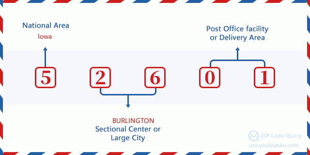
52601 Basic Meaning
What does each digit of ZIP Code 52601 stands for? The first digit designates a national area, which ranges from zero for the Northeast to nine for the far West. The 2-3 digits are the code of a sectional center facility in that region. The last two digits designate small post offices or postal zones.
Online Map

This is online map of the address Burlington, Iowa, United States. You may use button to move and zoom in / out. The map information is for reference only.
Museum

This is the ZIP Code 52601 - Museum page list. Its detail Museum Name, Street, City, State, ZIP Code, Phone is as below.
| Name | Street | City | State | ZIP Code | Phone |
| PHELPS HOUSE | 521 COLUMBIA ST | BURLINGTON | IA | 52601 | (319) 753-5880 |
| APPLE TREES MUSEUM | 1616 DILL ST | BURLINGTON | IA | 52601 | (319) 753-2449 |
| HENDERSON COUNTY HISTORICAL SOCIETY | DON DIXON 11912 HWY 99 NO 41 | BURLINGTON | IA | 52601 |
Library

This is the ZIP Code 52601 - Library page list. Its detail Library Name, Address, City, State, ZIP Code, Phone is as below.
- Name: BURLINGTON PUBLIC LIBRARY
- Address: 210 COURT ST
- City: BURLINGTON
- State: IA - Iowa
- ZIP Code: 52601
- Phone: (319) 753-1647
School

This is the ZIP Code 52601 - School page list. Its detail School Name, Address, City, State, ZIP Code is as below.
| School Name | Address | City | State | Grades | ZIP Code |
|---|---|---|---|---|---|
| Black Hawk Elementary School | 2804 S 14th St | Burlington | IA | UG | 52601 |
| Burlington Community High School | 421 Terrace Dr | Burlington | IA | UG | 52601 |
| Edward Stone Middle School | 3000 MASON RD. | Burlington | IA | UG | 52601 |
| James Wilson Grimes School | 800 SOUTH ST. | Burlington | IA | UG | 52601 |
| North Hill Elementary School | 825 N. 9TH ST. | Burlington | IA | UG | 52601 |
| Aldo Leopold Intermediate School | 3075 SUNNYSIDE | Burlington | IA | UG | 52601 |
| Sunnyside Elementary School | 2040 SUNNYSIDE AVE. | Burlington | IA | UG | 52601 |
| Corse Early Childhood Center | 700 SOUTH STARR AVENUE | BURLINGTON | IA | UG | 52601 |
Population for ZIP Code 52601

What is the total population in ZIP Code 52601? Below is detail information.
- Population for ZIP Code 52601: 29,147
- 2010 Population: 29,723
The 2020 demographic statistics are in progress. The current population in ZIP code 52601 is 29,147, and the population in 2010 is 29,723.
Gender

In all the statistical population, the male population is 14,388, the female population is 15,335.
- Male Population: 14,388
- Female Population: 15,335
Race

In all the statistical population, the male population is 14,388, the female population is 15,335.
- White Population: 27,328
- Black Population: 2,372
- Hispanic Population: 854
- Asian Population: 312
- Hawaiian Population: 29
- Indian Population: 247
- Other Population: 261
Age

In all the statistical population, the White population is 27,328, the Black population is 2,372, the Hispanic population is 854, the Asian population is 312, the Hawaiian population is 29, the Indian Ppopulation is 247 and Other population is 261.
- Age's Median: 40.9
- Median of male age: 39.4
- Median of female age: 42.5
Households for ZIP Code 52601
ZIP code 52601 has 12,618 households, with an average number of 2.31 persons per household. The average income per household in Zip code 52601 is 48,419 USD, and the average house value is 98,100 USD.
- Households Per Zipcode: 12,618
- Persons Per Household: 2.31
- Average House Value: 98,100
- Income Per Household: 48,419
Geographic

The latitude of the Zip code 52601 is 40.841262, the longitude is -91.113796, and the elevation is 531. It has land area of 110.865 square miles, and water area of 9.625 square miles. The time zone for ZIP code 52601 is Central (GMT -06:00). Daylight saving time should be observed in the area where the zip code is located.
- Latitude: 40.841262
- Longitude: -91.113796
- Elevation: 531
- Land Area: 110.865
- Water Area: 9.625
- Time Zone: Central (GMT -06:00)
- Region: Midwest
- Division: West North Central
- Day Light Saving: Y
Congressional District

The Congressional District for ZIP code 52601 is Iowa's 2nd congressional district, the Congressional Land Area is 12261.92 square mile.
- Congressional District: 2nd
- Congressional Land Area: 12261.92
Delivery

In the ZIP code 52601, there are 12,618 residential delivery mailboxes and centralized units, and 943 commercial delivery mailbox and centralized units, 11,038 single family deliveries and 720 multifamily deliveries, and the box count is 14,000. The main post office has city delivery carrier routes for the ZIP code 52601.
- Delivery Residential: 12,618
- Delivery Business: 943
- Delivery Total: 14,000
- Single Family Delivery Units: 11,038
- Multi Family Delivery Units: 720
- City Delivery Indicator: Y
Business

In ZIP code 52601, the number of business is 709, the number of employee is 11,290, the business first quarter payroll is 101,478,000 USD, the business annual payroll is 414,388,000 USD.
- Number Of Businesses: 709
- Number Of Employees: 11,290
- Business First Quarter Payroll: 101,478,000
- Business Annual Payroll: 414,388,000
Social Security Benefits

There are 7,195 beneficiaries with benefits in current-payment status for ZIP code 52601, of which 5,150 are retired workers, 995 are disabled workers, 400 are widow(er)s and parents, 195 are spouses and 455 are children. The number of beneficiaries aged 65 or older is 5,470. The total monthly benefits are 9,970,000 USD, of which 7,808,000 USD for retired workers, 593,000 USD for widow(er)s and parents.
- Total Number: 7,195
- Retired workers Number: 5,150
- Disabled workers Number: 995
- Widow(er)s and parents Number: 400
- Spouses Number: 195
- Children Number: 455
- All beneficiaries per month: 9,970,000
- Retired workers per month: 7,808,000
- Widow(er)s and parents per month: 593,000
- Number of beneficiaries aged 65 or older: 5,470


Add new comment