United States ZIP Code: 52742
This is the Iowa ZIP Code 52742 page list. Its detail State, County, City, Longitude, Latitude, Envelope Example, Population is as below.
ZIP Code 52742 Information

ZIP Code 52742 - City

This is the city information corresponding to 52742:
| State | County | City | City Type ?In many cases, a ZIP Code can have multiple "names", meaning cities, towns, or subdivisions, in its boundaries. However, it will ALWAYS have exactly 1 "default" name. D - Default - This is the "preferred" name - by the USPS - for a city. Each ZIP Code has one - and only one - "default" name. In most cases, this is what people who live in that area call the city as well. A - Acceptable - This name can be used for mailing purposes. Often times alternative names are large neighborhoods or sections of the city/town. In some cases a ZIP Code may have several "acceptable" names which is used to group towns under one ZIP Code. N - Not Acceptable - A "not acceptable" name is, in many cases, a nickname that residents give that location. According to the USPS, you should NOT send mail to that ZIP Code using the "not acceptable" name when mailing. | ZIP Code |
|---|---|---|---|---|
| IA | Clinton | De Witt | D (Default) | 52742 |
| IA | Clinton | Dewitt | N (Not Acceptable) | 52742 |
❓What does D (Default) mean? This is the "preferred" name - by the USPS - for a city. Each ZIP Code has one - and only one - "default" name. In most cases, this is what people who live in that area call the city as well.
❓What does N (Not Acceptable) mean? A "not acceptable" name is, in many cases, a nickname that residents give that location. According to the USPS, you should NOT send mail to that ZIP Code using the "not acceptable" name when mailing.
ZIP Code 52742 Plus 4
ZIP Code 5 plus 4 is the extension of 5-digit zip code, It can be used to locate a more detailed location. The last four digits designate segment or one side of a street or an apartment. You can find the ZIP+4 code and corresponding address of the zip code 52742 below.
| ZIP Code 5 Plus 4 | Address |
|---|---|
| 52742-0011 | PO BOX 11, DE WITT, IA |
| 52742-0131 | PO BOX 131, DE WITT, IA |
| 52742-0251 | PO BOX 251, DE WITT, IA |
| 52742-0290 | PO BOX 290, DE WITT, IA |
| 52742-0291 | PO BOX 291, DE WITT, IA |
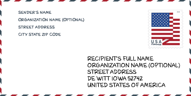
Envelope Example

This is an example of a US zip envelope. You can use a 5-digit zipcode or a detailed 9-digit zipcode to copy the mail in the following address format.
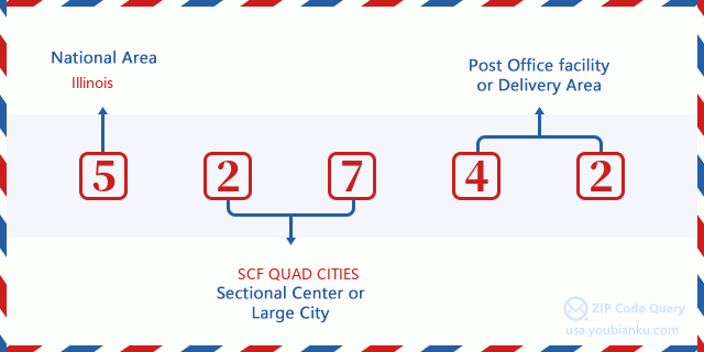
52742 Basic Meaning
What does each digit of ZIP Code 52742 stands for? The first digit designates a national area, which ranges from zero for the Northeast to nine for the far West. The 2-3 digits are the code of a sectional center facility in that region. The last two digits designate small post offices or postal zones.
Online Map

This is online map of the address Dewitt, Iowa, United States. You may use button to move and zoom in / out. The map information is for reference only.
Hospital

This is the ZIP Code 52742 - Hospital page list. Its detail Hospital Name, Street, City, State, ZIP Code, Phone is as below.
- Name: GENESIS MEDICAL CENTER-DEWITT
- Address: DEWITT
- City: 1118 11TH STREET
- State: IA
- ZIP Code: 52742
- Phone: (563) 659-4200
Library

This is the ZIP Code 52742 - Library page list. Its detail Library Name, Address, City, State, ZIP Code, Phone is as below.
| Name | Address | City | State | ZIP Code | Phone |
|---|---|---|---|---|---|
| FRANCES BANTA WAGGONER COMMUNITY LIBRARY | 505 10TH ST | DE WITT | IA | 52742 | (563) 659-5523 |
| FRANCES BANTA WAGGONER COMMUNITY LIBRARY | 505 10TH ST | DEWITT | IA | 52742 | (563) 659-5523 |
School

This is the ZIP Code 52742 - School page list. Its detail School Name, Address, City, State, ZIP Code is as below.
| School Name | Address | City | State | Grades | ZIP Code |
|---|---|---|---|---|---|
| Central DeWitt High School | 519 E. 11TH ST. | De Witt | IA | UG | 52742 |
| Central DeWitt Middle School | 425 E. 11TH ST. | De Witt | IA | UG | 52742 |
| Ekstrand Elementary School | 1140 15th St | De Witt | IA | UG | 52742 |
| Central DeWitt Intermediate School | 1010 4TH AVE. E. | DEWITT | IA | UG | 52742 |
Population for ZIP Code 52742

What is the total population in ZIP Code 52742? Below is detail information.
- Population for ZIP Code 52742: 7,716
- 2010 Population: 7,618
The 2020 demographic statistics are in progress. The current population in ZIP code 52742 is 7,716, and the population in 2010 is 7,618.
Gender

In all the statistical population, the male population is 3,708, the female population is 3,910.
- Male Population: 3,708
- Female Population: 3,910
Race

In all the statistical population, the male population is 3,708, the female population is 3,910.
- White Population: 7,513
- Black Population: 82
- Hispanic Population: 123
- Asian Population: 56
- Hawaiian Population: 5
- Indian Population: 26
- Other Population: 29
Age

In all the statistical population, the White population is 7,513, the Black population is 82, the Hispanic population is 123, the Asian population is 56, the Hawaiian population is 5, the Indian Ppopulation is 26 and Other population is 29.
- Age's Median: 41.1
- Median of male age: 39.9
- Median of female age: 42.4
Households for ZIP Code 52742
ZIP code 52742 has 3,040 households, with an average number of 2.47 persons per household. The average income per household in Zip code 52742 is 63,722 USD, and the average house value is 163,100 USD.
- Households Per Zipcode: 3,040
- Persons Per Household: 2.47
- Average House Value: 163,100
- Income Per Household: 63,722
Geographic

The latitude of the Zip code 52742 is 41.838930, the longitude is -90.495325, and the elevation is 663. It has land area of 117.214 square miles, and water area of 0.216 square miles. The time zone for ZIP code 52742 is Central (GMT -06:00). Daylight saving time should be observed in the area where the zip code is located.
- Latitude: 41.838930
- Longitude: -90.495325
- Elevation: 663
- Land Area: 117.214
- Water Area: 0.216
- Time Zone: Central (GMT -06:00)
- Region: Midwest
- Division: West North Central
- Day Light Saving: Y
Congressional District

The Congressional District for ZIP code 52742 is Iowa's 2nd congressional district, the Congressional Land Area is 12261.92 square mile.
- Congressional District: 2nd
- Congressional Land Area: 12261.92
Delivery

In the ZIP code 52742, there are 3,124 residential delivery mailboxes and centralized units, and 191 commercial delivery mailbox and centralized units, 2,711 single family deliveries and 129 multifamily deliveries, and the box count is 3,494. The main post office has city delivery carrier routes for the ZIP code 52742.
- Delivery Residential: 3,124
- Delivery Business: 191
- Delivery Total: 3,494
- Single Family Delivery Units: 2,711
- Multi Family Delivery Units: 129
- City Delivery Indicator: Y
Business

In ZIP code 52742, the number of business is 222, the number of employee is 2,867, the business first quarter payroll is 26,363,000 USD, the business annual payroll is 111,352,000 USD.
- Number Of Businesses: 222
- Number Of Employees: 2,867
- Business First Quarter Payroll: 26,363,000
- Business Annual Payroll: 111,352,000
Social Security Benefits

There are 1,690 beneficiaries with benefits in current-payment status for ZIP code 52742, of which 1,330 are retired workers, 130 are disabled workers, 105 are widow(er)s and parents, 50 are spouses and 75 are children. The number of beneficiaries aged 65 or older is 1,390. The total monthly benefits are 2,456,000 USD, of which 2,030,000 USD for retired workers, 168,000 USD for widow(er)s and parents.
- Total Number: 1,690
- Retired workers Number: 1,330
- Disabled workers Number: 130
- Widow(er)s and parents Number: 105
- Spouses Number: 50
- Children Number: 75
- All beneficiaries per month: 2,456,000
- Retired workers per month: 2,030,000
- Widow(er)s and parents per month: 168,000
- Number of beneficiaries aged 65 or older: 1,390


Add new comment