ZIP Code: 70129, New Orleans, LA
ZIP Code 70129 is located in New Orleans, Louisiana. Its detail State, County, City, Longitude, Latitude, Envelope Example, Population is as below.
ZIP Code 70129 Information

-
-
Country:
U.S. - United States
State:
County FIPS:
22071
County:
City:
Area Code:
City Type ?In many cases, a ZIP Code can have multiple "names", meaning cities, towns, or subdivisions, in its boundaries. However, it will ALWAYS have exactly 1 "default" name. D - Default - This is the "preferred" name - by the USPS - for a city. Each ZIP Code has one - and only one - "default" name. In most cases, this is what people who live in that area call the city as well. A - Acceptable - This name can be used for mailing purposes. Often times alternative names are large neighborhoods or sections of the city/town. In some cases a ZIP Code may have several "acceptable" names which is used to group towns under one ZIP Code. N - Not Acceptable - A "not acceptable" name is, in many cases, a nickname that residents give that location. According to the USPS, you should NOT send mail to that ZIP Code using the "not acceptable" name when mailing.:
D (Default)
ZIP Code:
70129
❓What does D (Default) mean? This is the "preferred" name - by the USPS - for a city. Each ZIP Code has one - and only one - "default" name. In most cases, this is what people who live in that area call the city as well.
ZIP Code 70129 Plus 4
ZIP Code 5 plus 4 is the extension of 5-digit zip code, It can be used to locate a more detailed location. The last four digits designate segment or one side of a street or an apartment. You can find the ZIP+4 code and corresponding address of the zip code 70129 below.
| ZIP Code 5 Plus 4 | Address |
|---|---|
| 70129-1000 | 14100 WILLOWBROOK DR, NEW ORLEANS, LA |
| 70129-1001 | 1 ACADIANA PL, NEW ORLEANS, LA |
| 70129-1002 | 2 ACADIANA PL, NEW ORLEANS, LA |
| 70129-1003 | 1 AVOYELLES PL, NEW ORLEANS, LA |
| 70129-1004 | 2 AVOYELLES PL, NEW ORLEANS, LA |
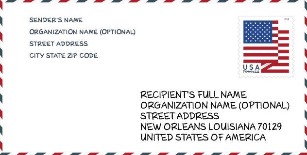
Envelope Example

This is an example of a US zip envelope. You can use a 5-digit zipcode or a detailed 9-digit zipcode to copy the mail in the following address format.
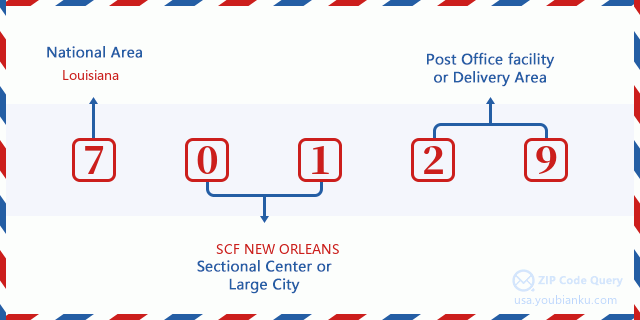
70129 Basic Meaning
What does each digit of ZIP Code 70129 stands for? The first digit designates a national area, which ranges from zero for the Northeast to nine for the far West. The 2-3 digits are the code of a sectional center facility in that region. The last two digits designate small post offices or postal zones.
Online Map

This is online map of the address New Orleans, Louisiana, United States. You may use button to move and zoom in / out. The map information is for reference only.
School

This is the ZIP Code 70129 - School page list. Its detail School Name, Address, City, State, ZIP Code is as below.
| School Name | Address | City | State | Grades | ZIP Code |
|---|---|---|---|---|---|
| Einstein Charter Middle Sch at Sarah Towles Reed | 5316 Michoud Blvd | New Orleans | LA | UG | 70129 |
| Einstein Charter School at Village De L'Est | 5316 Michoud Blvd | New Orleans | LA | UG | 70129 |
| Einstein Charter at Sherwood Forest | 4801 Maid Marion | New Orleans | LA | UG | 70129 |
| Einstein Charter High School at Sarah Towles Reed | 5316 Michoud Blvd | New Orleans | LA | UG | 70129 |
Population for ZIP Code 70129

What is the total population in ZIP Code 70129? Below is detail information.
- Population for ZIP Code 70129: 12,345
- 2010 Population: 9,064
The 2020 demographic statistics are in progress. The current population in ZIP code 70129 is 12,345, and the population in 2010 is 9,064.
Gender

In all the statistical population, the male population is 4,607, the female population is 4,457.
- Male Population: 4,607
- Female Population: 4,457
Race

In all the statistical population, the male population is 4,607, the female population is 4,457.
- White Population: 1,280
- Black Population: 3,669
- Hispanic Population: 834
- Asian Population: 3,690
- Hawaiian Population: 4
- Indian Population: 45
- Other Population: 538
Age

In all the statistical population, the White population is 1,280, the Black population is 3,669, the Hispanic population is 834, the Asian population is 3,690, the Hawaiian population is 4, the Indian Ppopulation is 45 and Other population is 538.
- Age's Median: 34.0
- Median of male age: 34.2
- Median of female age: 33.7
Households for ZIP Code 70129
ZIP code 70129 has 2,830 households, with an average number of 3.19 persons per household. The average income per household in Zip code 70129 is 35,386 USD, and the average house value is 152,000 USD.
- Households Per Zipcode: 2,830
- Persons Per Household: 3.19
- Average House Value: 152,000
- Income Per Household: 35,386
Housing Unit

In ZIP code 70129, the growth rank of housing unit is 9, the number of housing unit was 343,829 in 2010 and increased to 360,740 in 2011, the growth increase number is 16,911, the growth increase percentage is 4.9%.
- Growth Rank: 9
- Housing Units Estimate in 2010: 343,829
- Housing Units Estimate in 2011: 360,740
- Growth Increase Number: 16,911
- Growth Increase Percentage: 4.9%
Geographic

The latitude of the Zip code 70129 is 30.089740, the longitude is -89.811925, and the elevation is 0. It has land area of 90.707 square miles, and water area of 43.463 square miles. The time zone for ZIP code 70129 is Central (GMT -06:00). Daylight saving time should be observed in the area where the zip code is located.
- Latitude: 30.089740
- Longitude: -89.811925
- Elevation: 0
- Land Area: 90.707
- Water Area: 43.463
- Time Zone: Central (GMT -06:00)
- Region: South
- Division: West South Central
- Day Light Saving: Y
Congressional District

The Congressional District for ZIP code 70129 is Louisiana's 2nd congressional district, the Congressional Land Area is 1268.48 square mile.
- Congressional District: 2nd
- Congressional Land Area: 1268.48
Delivery

In the ZIP code 70129, there are 3,870 residential delivery mailboxes and centralized units, and 290 commercial delivery mailbox and centralized units, 2,909 single family deliveries and 248 multifamily deliveries, and the box count is 4,300. The main post office has city delivery carrier routes for the ZIP code 70129.
- Delivery Residential: 3,870
- Delivery Business: 290
- Delivery Total: 4,300
- Single Family Delivery Units: 2,909
- Multi Family Delivery Units: 248
- City Delivery Indicator: Y
Business

In ZIP code 70129, the number of business is 158, the number of employee is 2,897, the business first quarter payroll is 41,837,000 USD, the business annual payroll is 167,733,000 USD.
- Number Of Businesses: 158
- Number Of Employees: 2,897
- Business First Quarter Payroll: 41,837,000
- Business Annual Payroll: 167,733,000
Social Security Benefits

There are 1,500 beneficiaries with benefits in current-payment status for ZIP code 70129, of which 935 are retired workers, 250 are disabled workers, 80 are widow(er)s and parents, 75 are spouses and 160 are children. The number of beneficiaries aged 65 or older is 1,015. The total monthly benefits are 1,538,000 USD, of which 1,088,000 USD for retired workers, 76,000 USD for widow(er)s and parents.
- Total Number: 1,500
- Retired workers Number: 935
- Disabled workers Number: 250
- Widow(er)s and parents Number: 80
- Spouses Number: 75
- Children Number: 160
- All beneficiaries per month: 1,538,000
- Retired workers per month: 1,088,000
- Widow(er)s and parents per month: 76,000
- Number of beneficiaries aged 65 or older: 1,015


Add new comment